Map of Milton city, Wisconsin
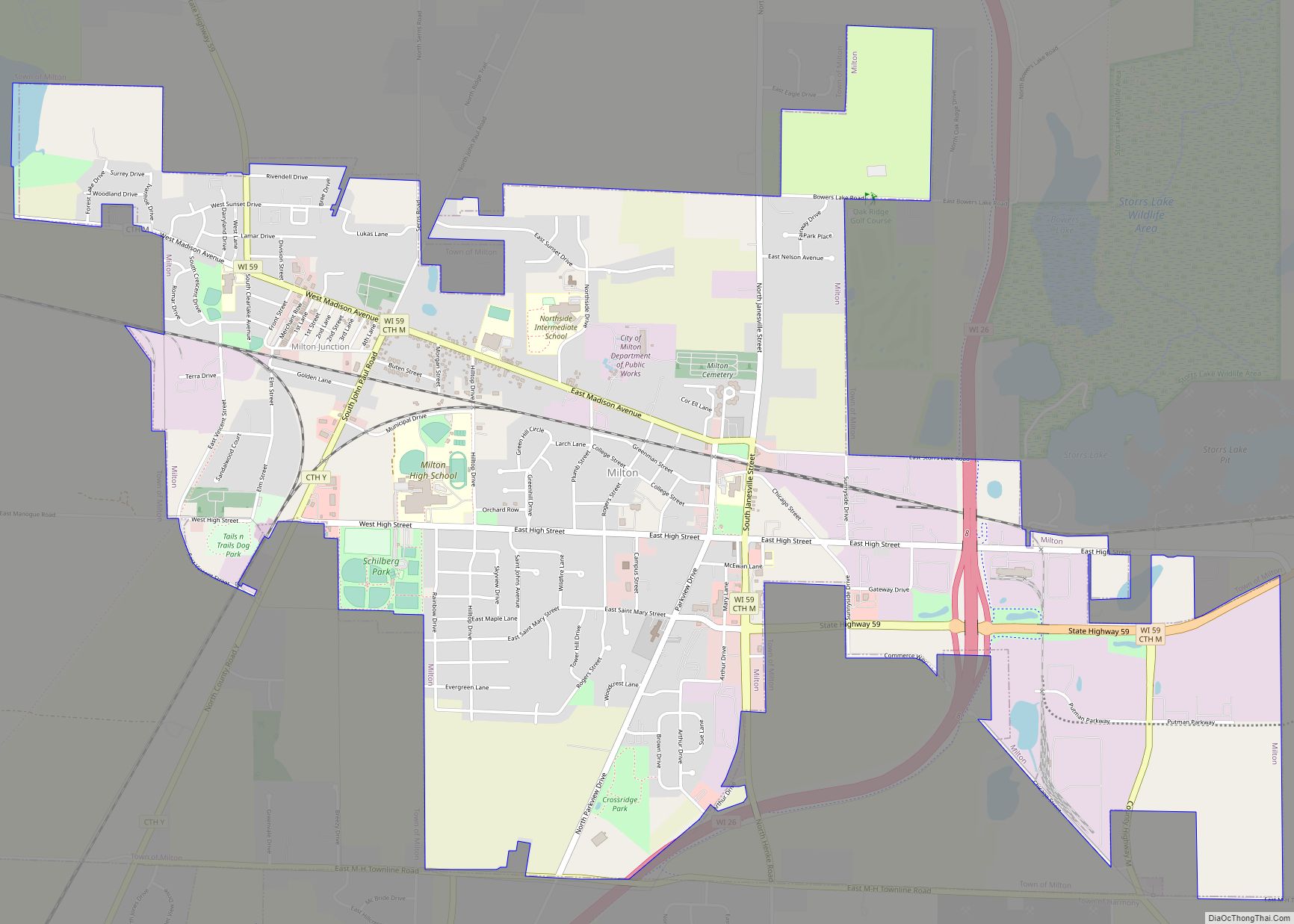
Milton is a city in Rock County, Wisconsin, United States. The population was 5,716 at the 2020 census. Milton city overview: Name: Milton city LSAD Code: 25 LSAD Description: city (suffix) State: Wisconsin County: Rock County Elevation: 889 ft (271 m) Total Area: 4.28 sq mi (11.08 km²) Land Area: 4.26 sq mi (11.03 km²) Water Area: 0.02 sq mi (0.04 km²) Total Population: 5,716 Population ... Read more
Map of Milton city, Wisconsin
Map of Milltown village, Wisconsin
Milltown is a town in Polk County, Wisconsin, United States. The population was 1,146 at the 2000 census. The village of Milltown is located within the town. Milltown village overview: Name: Milltown village LSAD Code: 47 LSAD Description: village (suffix) State: Wisconsin County: Polk County FIPS code: 5552075 Online Interactive Map Milltown online map. Source: ... Read more
Map of Milltown village, Wisconsin
Map of Mount Calvary village
Mount Calvary is a village in Fond du Lac County, Wisconsin, United States. The population was 762 at the 2010 census, down from 956 residents at the 2000 census. Mount Calvary village overview: Name: Mount Calvary village LSAD Code: 47 LSAD Description: village (suffix) State: Wisconsin County: Fond du Lac County Elevation: 958 ft (292 m) Total ... Read more
Map of Mount Calvary village
Map of Millston CDP
Millston is an unincorporated census-designated place located in the town of Millston, Jackson County, Wisconsin, United States. Millston is located along U.S. Route 12 and Interstate 94 12.5 miles (20.1 km) southeast of Black River Falls. As of the 2010 census, its population is 125. Millston is surrounded by the Black River State Forest. Millston CDP ... Read more
Map of Millston CDP
Map of Neillsville city
Neillsville is a city in Clark County in the U.S. state of Wisconsin. The population was 2,384 at the 2020 census. It is the county seat. Neillsville city overview: Name: Neillsville city LSAD Code: 25 LSAD Description: city (suffix) State: Wisconsin County: Clark County Elevation: 1,037 ft (316 m) Total Area: 2.85 sq mi (7.37 km²) Land Area: 2.75 sq mi (7.11 km²) ... Read more
Map of Neillsville city
Map of Necedah village
The Town of Necedah /nəˈsiːdə/ is a town in Juneau County, United States. The population was 2,156 at the 2000 census. The Village of Necedah is located within the town. The unincorporated communities of Cloverdale and Sprague are also located in the town. Necedah village overview: Name: Necedah village LSAD Code: 47 LSAD Description: village ... Read more
Map of Necedah village
Map of Navarino CDP
Navarino is an unincorporated community located in the town of Navarino, Shawano County, Wisconsin, United States. Navarino is located on Wisconsin Highway 156 3.5 miles (5.6 km) north-northwest of Nichols, in section 25 of the town. As of the 2010 census, its population is 177. For statistical purposes, the United States Census Bureau has defined Navarino ... Read more
Map of Navarino CDP
Map of Nashotah village
Nashotah is a village in Waukesha County, Wisconsin, United States. The population was 1,321 at the 2020 census. The village took its name from the nearby Nashotah Lakes. Nashotah village overview: Name: Nashotah village LSAD Code: 47 LSAD Description: village (suffix) State: Wisconsin County: Waukesha County Elevation: 942 ft (287 m) Total Area: 1.66 sq mi (4.31 km²) Land Area: ... Read more
Map of Nashotah village
Map of Muskego city
Muskego (/mʌsˈkiɡoʊ/) is a city in Waukesha County, Wisconsin, United States. As of the 2020 census, the city had a population of 25,032. Muskego is the fifth largest community in Waukesha County, Wisconsin. Muskego has a large Norwegian population. The name Muskego is derived from the Potawatomi Indian name for the area, “Mus-kee-Guaac”, meaning sunfish. ... Read more
Map of Muskego city
Map of Muscoda village
Muscoda is a village in Grant and Iowa counties in the U.S. state of Wisconsin. The population was 1,299 at the 2010 census. Of this, 1,249 were in Grant County and 50 were in Iowa County. The Grant County part of the village is adjacent to the Town of Muscoda and the Iowa County part ... Read more
Map of Muscoda village
Map of Mukwonago village
Mukwonago /mʌˈkwɒnəɡoʊ/ is a village in the U.S. state of Wisconsin. The population was 8,262 at the 2020 census. The village is located mostly within the Town of Mukwonago in Waukesha County, with a small portion extending into the Town of East Troy in Walworth County. Of its population, 8,040 are in Waukesha County and ... Read more
Map of Mukwonago village
Map of Mountain CDP, Wisconsin
Mountain is an unincorporated census-designated place in Oconto County, Wisconsin, United States. The community is located at the intersection of Wisconsin Highway 32 and Wisconsin Highway 64, in the town of Mountain. It is located at latitude 45.185 and longitude -88.474 and elevation 971 feet (mean sea level). The postal code for Mountain is 54149. ... Read more
Map of Mountain CDP, Wisconsin