Map of Pence CDP
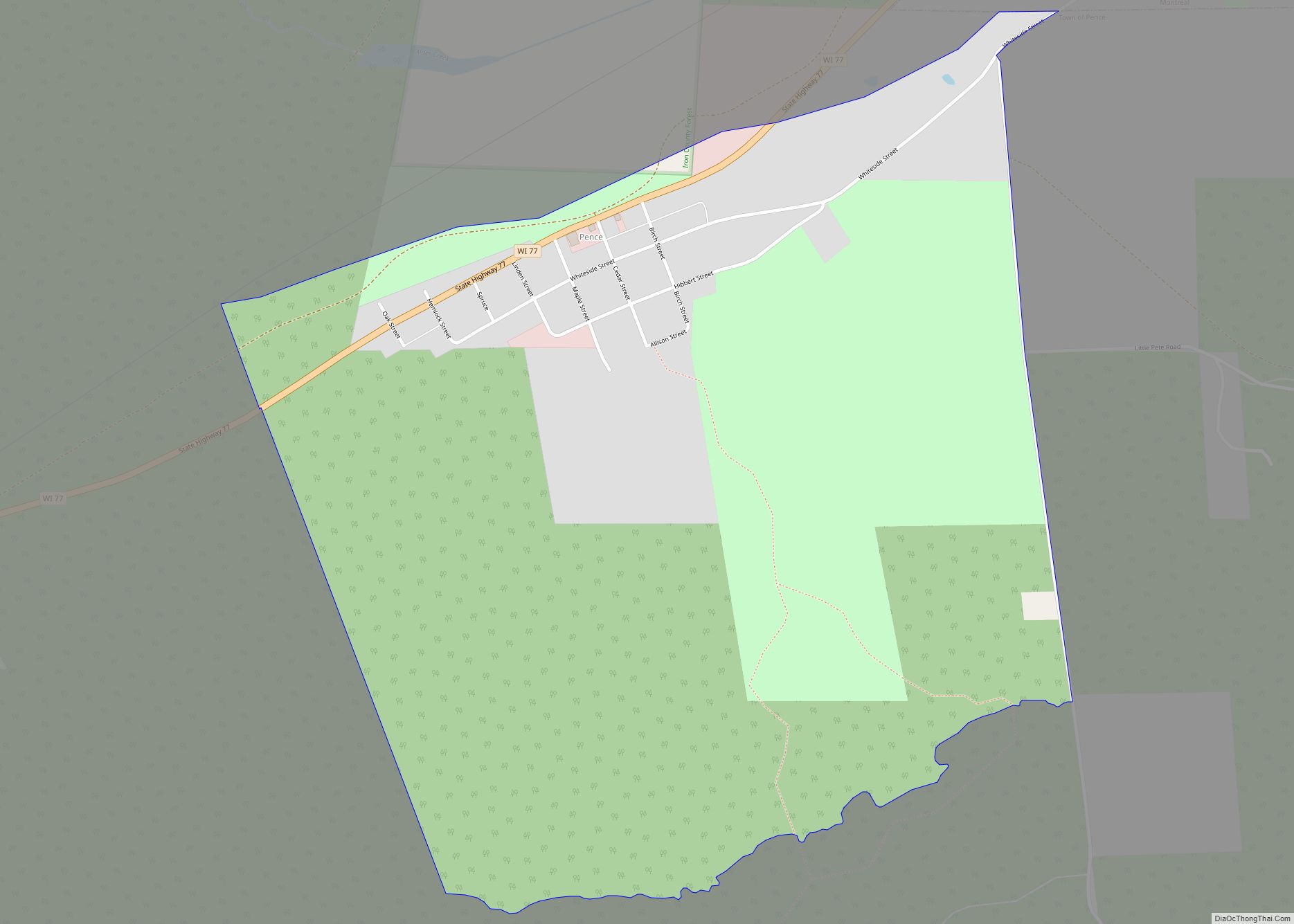
Pence is an unincorporated census-designated place located in the town of Pence, Iron County, Wisconsin, United States. Pence is located on Wisconsin Highway 77 1.5 miles (2.4 km) southwest of Montreal. As of the 2010 census, its population is 131. Pence CDP overview: Name: Pence CDP LSAD Code: 57 LSAD Description: CDP (suffix) State: Wisconsin County: ... Read more
Map of Pence CDP
Map of Pembine CDP
Pembine is an unincorporated census-designated place in Marinette County, Wisconsin (USA), in the town of Pembine. It is located on U.S. Route 141 and U.S. Route 8. It uses the Postal ZIP code 54156. As of the 2010 census, its population is 193. Pembine CDP overview: Name: Pembine CDP LSAD Code: 57 LSAD Description: CDP ... Read more
Map of Pembine CDP
Map of Pella CDP, Wisconsin
Pella is a census-designated place in the town of Pella, Shawano County, Wisconsin, United States. Its population was 185 as of the 2010 census. Pella is located along the Embarrass River. Pella CDP overview: Name: Pella CDP LSAD Code: 57 LSAD Description: CDP (suffix) State: Wisconsin County: Shawano County Elevation: 869 ft (265 m) Total Area: 1.719 sq mi ... Read more
Map of Pella CDP, Wisconsin
Map of Patch Grove village
Patch Grove is a village in Grant County, Wisconsin, United States. The population was 198 at the 2010 census. The village is located within the Town of Patch Grove. Patch Grove village overview: Name: Patch Grove village LSAD Code: 47 LSAD Description: village (suffix) State: Wisconsin County: Grant County FIPS code: 5561425 Online Interactive Map ... Read more
Map of Patch Grove village
Map of Park Ridge village, Wisconsin
Park Ridge is a village in Portage County, Wisconsin, United States and is a suburb of Stevens Point. It is included in the Stevens Point Micropolitan Statistical Area. The population was 530 at the 2020 census. Park Ridge village overview: Name: Park Ridge village LSAD Code: 47 LSAD Description: village (suffix) State: Wisconsin County: Portage ... Read more
Map of Park Ridge village, Wisconsin
Map of Park Falls city
Park Falls is a city in Price County, Wisconsin, United States. The population was 2,462 at the 2010 census. Located in the woods of north central Wisconsin, primarily the Chequamegon National Forest, Park Falls is a small community divided by the North Fork of the Flambeau River, a popular destination for fishing, canoeing and whitewater ... Read more
Map of Park Falls city
Map of Pardeeville village
Pardeeville is a village in Columbia County, Wisconsin, United States. The population was 2,115 at the 2010 census. It is part of the Madison Metropolitan Statistical Area. Pardeeville village overview: Name: Pardeeville village LSAD Code: 47 LSAD Description: village (suffix) State: Wisconsin County: Columbia County Elevation: −1,738 ft (247 m) Total Area: 2.27 sq mi (5.87 km²) Land Area: 1.92 sq mi ... Read more
Map of Pardeeville village
Map of Palmyra village, Wisconsin
Palmyra is a town in Jefferson County, Wisconsin, United States. The population was 1,707 at the 2020 census. The village of Palmyra is located within the town. Palmyra village overview: Name: Palmyra village LSAD Code: 47 LSAD Description: village (suffix) State: Wisconsin County: Jefferson County FIPS code: 5561025 Online Interactive Map Palmyra online map. Source: ... Read more
Map of Palmyra village, Wisconsin
Map of Plain village
Plain is a village in Sauk County, Wisconsin, United States. The population was 773 at the 2010 census. Plain village overview: Name: Plain village LSAD Code: 47 LSAD Description: village (suffix) State: Wisconsin County: Sauk County Elevation: 810 ft (247 m) Total Area: 0.83 sq mi (2.16 km²) Land Area: 0.83 sq mi (2.16 km²) Water Area: 0.00 sq mi (0.00 km²) Total Population: 773 Population ... Read more
Map of Plain village
Map of Paddock Lake village
Paddock Lake is a village in Kenosha County, Wisconsin, United States. The population was 2,919 at the 2020 census. Paddock Lake village overview: Name: Paddock Lake village LSAD Code: 47 LSAD Description: village (suffix) State: Wisconsin County: Kenosha County Elevation: 817 ft (249 m) Total Area: 3.11 sq mi (8.05 km²) Land Area: 2.90 sq mi (7.51 km²) Water Area: 0.21 sq mi (0.54 km²) Total ... Read more
Map of Paddock Lake village
Map of Pittsville city, Wisconsin
Pittsville is a city in Wood County, Wisconsin, United States. The population was 874 at the 2010 census. Pittsville city overview: Name: Pittsville city LSAD Code: 25 LSAD Description: city (suffix) State: Wisconsin County: Wood County Elevation: 1,033 ft (315 m) Total Area: 2.00 sq mi (5.18 km²) Land Area: 1.99 sq mi (5.15 km²) Water Area: 0.01 sq mi (0.03 km²) Total Population: 874 Population ... Read more
Map of Pittsville city, Wisconsin
Map of Packwaukee CDP
Packwaukee is an unincorporated census-designated place located in the town of Packwaukee, Marquette County, Wisconsin, United States. Packwaukee is located on the north bank of Buffalo Lake, a lake on the Fox River; it is 7 miles (11 km) west-southwest of Montello. Packwaukee has a post office with ZIP code 53953. As of the 2010 census, ... Read more
Map of Packwaukee CDP