Map of Orfordville village
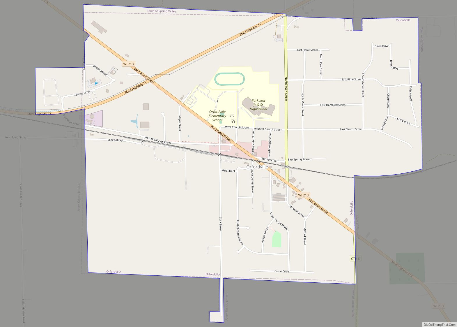
Orfordville is a village in Rock County, Wisconsin, United States. It is located at the intersection of Highway 11, Highway 213, and the Wisconsin and Southern Railroad. The population was 1,473 at the 2020 census. Orfordville village overview: Name: Orfordville village LSAD Code: 47 LSAD Description: village (suffix) State: Wisconsin County: Rock County Elevation: 889 ft ... Read more
Map of Orfordville village
Map of Oakdale village, Wisconsin
Oakdale is a town in Monroe County, Wisconsin, United States. The population was 679 at the 2000 census. The Village of Oakdale is located within the town. Oakdale village overview: Name: Oakdale village LSAD Code: 47 LSAD Description: village (suffix) State: Wisconsin County: Monroe County FIPS code: 5558850 Online Interactive Map Oakdale online map. Source: ... Read more
Map of Oakdale village, Wisconsin
Map of Oregon village, Wisconsin
Oregon is a village in Dane County, Wisconsin. As of the census of 2020, the population was 11,179. Oregon is part of the Madison Metropolitan Statistical Area. The village is located mostly within the Town of Oregon. Oregon village overview: Name: Oregon village LSAD Code: 47 LSAD Description: village (suffix) State: Wisconsin County: Dane County ... Read more
Map of Oregon village, Wisconsin
Map of Oostburg village
Oostburg is a village in Sheboygan County, Wisconsin, United States. The population was 2,887 at the 2010 census. It is included in the Sheboygan, Wisconsin Metropolitan Statistical Area. Oostburg village overview: Name: Oostburg village LSAD Code: 47 LSAD Description: village (suffix) State: Wisconsin County: Sheboygan County Elevation: 699 ft (213 m) Total Area: 1.96 sq mi (5.08 km²) Land Area: ... Read more
Map of Oostburg village
Map of Ontario village, Wisconsin
Ontario is a village in Vernon County, Wisconsin, United States. The population was 554 at the 2010 census. Ontario village overview: Name: Ontario village LSAD Code: 47 LSAD Description: village (suffix) State: Wisconsin County: Vernon County Elevation: 919 ft (280 m) Total Area: 1.01 sq mi (2.62 km²) Land Area: 1.00 sq mi (2.60 km²) Water Area: 0.01 sq mi (0.02 km²) Total Population: 554 Population ... Read more
Map of Ontario village, Wisconsin
Map of Onalaska city, Wisconsin
Onalaska is a city in La Crosse County, Wisconsin, United States. The population was 18,803 at the 2020 census. It borders the larger La Crosse, Wisconsin, and is a part of the La Crosse-Onalaska, WI-MN Metropolitan Area. Onalaska is built on a slightly elevated ridge above the Black River. Natural areas include both river bottom ... Read more
Map of Onalaska city, Wisconsin
Map of Oliver village, Wisconsin
Oliver is a village in Douglas County, Wisconsin, United States. The population was 423 at the 2020 census. Oliver is located 5 miles (8.0 km) west of the city of Superior and 0.3 miles (0.48 km) east of Gary – New Duluth, Duluth, Minnesota. Oliver village overview: Name: Oliver village LSAD Code: 47 LSAD Description: village (suffix) ... Read more
Map of Oliver village, Wisconsin
Map of Okauchee Lake CDP
Okauchee Lake is a census-designated place (CDP) in Waukesha County, Wisconsin, United States. The population was 5,094 at the 2020 census. Okauchee Lake is located in the town of Oconomowoc. Okauchee Lake CDP overview: Name: Okauchee Lake CDP LSAD Code: 57 LSAD Description: CDP (suffix) State: Wisconsin County: Waukesha County Elevation: 883 ft (269 m) Total Area: ... Read more
Map of Okauchee Lake CDP
Map of Ogdensburg village, Wisconsin
Ogdensburg is a village in Waupaca County, Wisconsin, United States. The population was 185 at the 2010 census. Ogdensburg village overview: Name: Ogdensburg village LSAD Code: 47 LSAD Description: village (suffix) State: Wisconsin County: Waupaca County Elevation: 850 ft (259 m) Total Area: 1.03 sq mi (2.66 km²) Land Area: 0.97 sq mi (2.52 km²) Water Area: 0.05 sq mi (0.14 km²) Total Population: 185 Population ... Read more
Map of Ogdensburg village, Wisconsin
Map of Odanah CDP
Odanah (Ojibwe: Oodena) is an unincorporated community and census-designated place (CDP) in Ashland County, Wisconsin, in the town of Sanborn, United States, on the banks of the Bad River. The population was 47 at the 2020 census. Odanah is the cultural and administrative center of the Bad River Chippewa Band of the Chippewa. For statistical ... Read more
Map of Odanah CDP
Map of Owen city
Owen is a city in Clark County in the U.S. state of Wisconsin. The population was 940 at the 2010 census. Owen is located directly east of the village of Withee, which is about half the size of Owen. Owen city overview: Name: Owen city LSAD Code: 25 LSAD Description: city (suffix) State: Wisconsin County: ... Read more
Map of Owen city
Map of Pewaukee village
Pewaukee is a village in Waukesha County, Wisconsin, United States. The population was 8,238 at the 2020 census. The village is nearly surrounded by the City of Pewaukee. The village was incorporated from what was formerly the Town of Pewaukee, and the remainder of the town later incorporated as a city. Pewaukee village overview: Name: ... Read more
Map of Pewaukee village