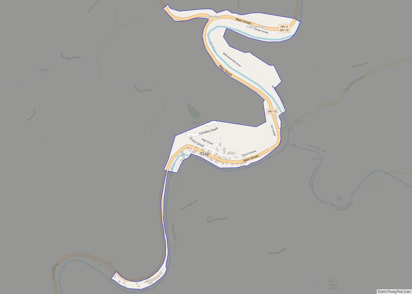
Clay is a town in and the county seat of Clay County, West Virginia, United States. The population was 399 at the 2020 census. It is the only incorporated town in Clay County. Clay town overview: Name: Clay town LSAD Code: 43 LSAD Description: town (suffix) State: West Virginia County: Clay County Elevation: 709 ft (216 m) ... Read more
Map of US Cities and Places
Chester is a city in northern Hancock County, West Virginia, United States, along the Ohio River. The population was 2,214 at the 2020 census. Located immediately south of Ohio and just west of Pennsylvania, Chester is the northernmost city in West Virginia. It is a part of the Weirton–Steubenville metropolitan area, and is home to ... Read more
Cheat Lake is a census-designated place in Monongalia County, West Virginia, United States, surrounding the Cheat Lake reservoir. The population was 9,930 at the 2020 census. It is included in the Morgantown metropolitan area. Cheat Lake CDP overview: Name: Cheat Lake CDP LSAD Code: 57 LSAD Description: CDP (suffix) State: West Virginia County: Monongalia County ... Read more
Crab Orchard is a census-designated place (CDP) in Raleigh County, West Virginia, United States. The population was 2,678 at the 2010 census. Crab Orchard CDP overview: Name: Crab Orchard CDP LSAD Code: 57 LSAD Description: CDP (suffix) State: West Virginia County: Raleigh County Elevation: 2,287 ft (697 m) Total Area: 2.2 sq mi (5.8 km²) Land Area: 2.2 sq mi (5.8 km²) Water ... Read more
Chattaroy is a census-designated place (CDP) in Mingo County, West Virginia, United States. The population was 756 at the 2010 census. The community’s name is an accurate preservation of the Native American name of the nearby Big Sandy River, Chattaroy. Chattaroy CDP overview: Name: Chattaroy CDP LSAD Code: 57 LSAD Description: CDP (suffix) State: West ... Read more
Cowen is a town in Webster County, West Virginia, United States. The population was 488 at the 2020 census. Cowen town overview: Name: Cowen town LSAD Code: 43 LSAD Description: town (suffix) State: West Virginia County: Webster County Elevation: 2,270 ft (692 m) Total Area: 0.63 sq mi (1.63 km²) Land Area: 0.63 sq mi (1.63 km²) Water Area: 0.00 sq mi (0.00 km²) Total Population: ... Read more
Charles Town is a city in and the county seat of Jefferson County, West Virginia, United States. The population was 6,534 at the 2020 census. The city is named for its founder Charles Washington, youngest brother of President George Washington. It is part of the northwestern fringes of the Washington metropolitan area. Charles Town city ... Read more
Comfort is a census-designated place (CDP) in Boone County, West Virginia, United States. Comfort is located on West Virginia Route 3, 12 miles (19 km) northeast of Madison. Comfort has a post office with ZIP code 25049. As of the 2010 census, its population is 306. Comfort is the home of Sherman Elementary School. Comfort CDP ... Read more
Crum is a census-designated place (CDP) in southern Wayne County, West Virginia, United States. As of the 2010 census, its population was 182. It is the home to Crum Pre K-8 school opened in 2017. It is a part of the Huntington-Ashland Metropolitan Statistical Area (MSA). Crum CDP overview: Name: Crum CDP LSAD Code: 57 ... Read more
East Bank is a town in Kanawha County, West Virginia, United States, situated along the Kanawha River. The population was 820 at the 2020 census. East Bank was incorporated in 1889 by special charter enacted by the West Virginia Legislature. It is so named on account of the town’s location on the east side of ... Read more
Cross Lanes is a census-designated place (CDP) and suburb of Charleston in Kanawha County, West Virginia, United States. As of the 2010 census, its population was 9,995. Cross Lanes CDP overview: Name: Cross Lanes CDP LSAD Code: 57 LSAD Description: CDP (suffix) State: West Virginia County: Kanawha County Elevation: 709 ft (216 m) Total Area: 6.4 sq mi (16.6 km²) ... Read more
Dunbar is a city in Kanawha County, West Virginia, United States, situated along the Kanawha River. The population was 7,479 at the 2020 census. Dunbar city overview: Name: Dunbar city LSAD Code: 25 LSAD Description: city (suffix) State: West Virginia County: Kanawha County Elevation: 594 ft (181 m) Total Area: 2.81 sq mi (7.27 km²) Land Area: 2.80 sq mi (7.26 km²) Water ... Read more