Map of Middlebourne town
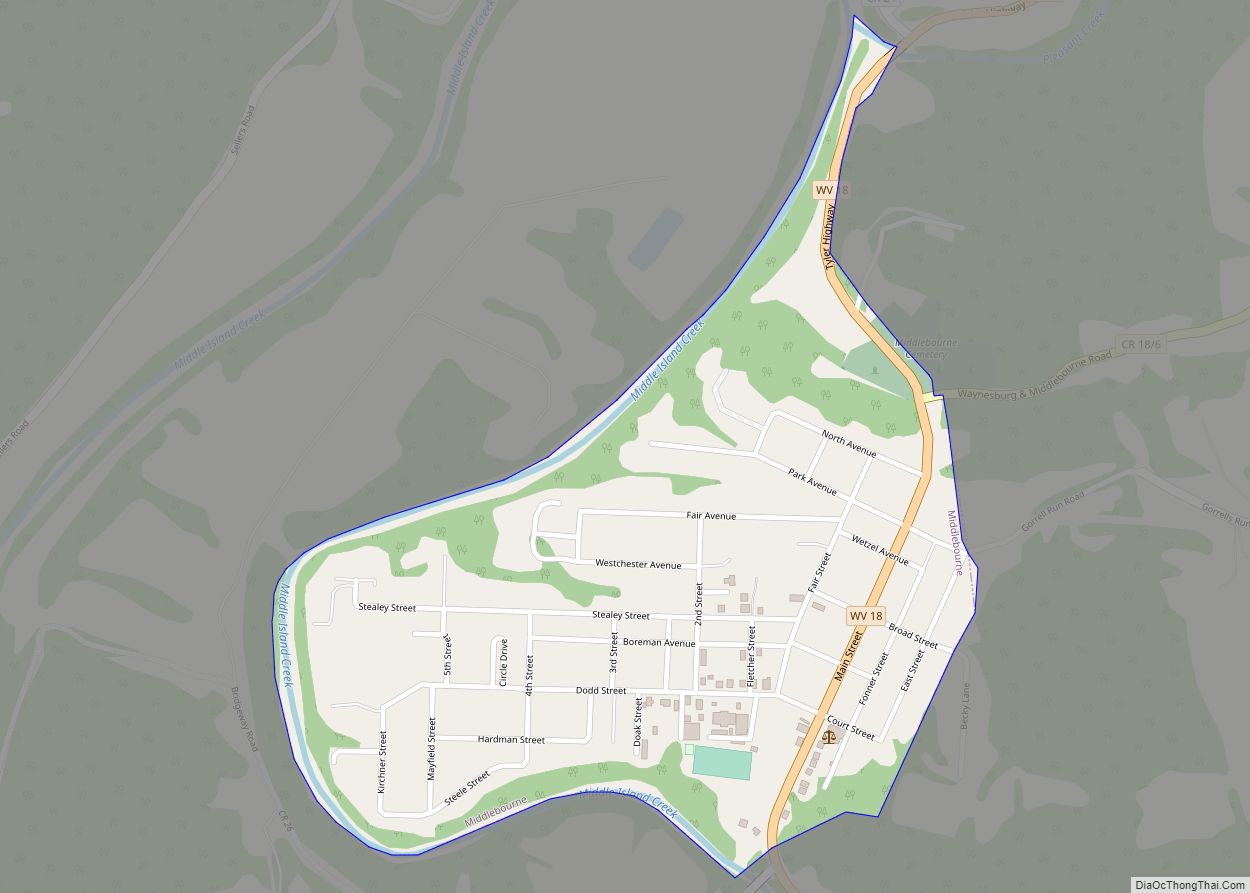
Middlebourne is a town in Tyler County, West Virginia, United States. The population was 715 at the 2020 census. It serves as the county seat of Tyler County. Middlebourne town overview: Name: Middlebourne town LSAD Code: 43 LSAD Description: town (suffix) State: West Virginia County: Tyler County Elevation: 735 ft (224 m) Total Area: 0.38 sq mi (0.98 km²) Land ... Read more
Map of Middlebourne town
Map of Mount Hope city, West Virginia
Mount Hope is a city in Fayette County, West Virginia, United States. The population was 1,414 at the 2010 census. Mount Hope city overview: Name: Mount Hope city LSAD Code: 25 LSAD Description: city (suffix) State: West Virginia County: Fayette County Elevation: 1,722 ft (525 m) Total Area: 1.56 sq mi (4.03 km²) Land Area: 1.56 sq mi (4.03 km²) Water Area: 0.00 sq mi ... Read more
Map of Mount Hope city, West Virginia
Map of Meadow Bridge town
Meadow Bridge is a town in Fayette County, West Virginia, United States. The population was 379 at the 2010 census. The first settler of the area was John Gwin, closely followed by Dan Griffin. The community took its name from a nearby bridge over Meadow Creek. Meadow Bridge town overview: Name: Meadow Bridge town LSAD ... Read more
Map of Meadow Bridge town
Map of Mount Gay-Shamrock CDP
Mount Gay-Shamrock is a census-designated place (CDP) in Logan County, West Virginia, United States. Mount Gay-Shamrock has a 2020 population of 1,360. Mount Gay-Shamrock is currently declining at a rate of -2.51% annually. The population was 1,779 at the 2010 census. The CDP includes the unincorporated communities of Mount Gay, Shamrock, Black Bottom, Whites Addition, ... Read more
Map of Mount Gay-Shamrock CDP
Map of McMechen city
McMechen is a city in Marshall County, West Virginia, United States, situated along the Ohio River. It is part of the Wheeling, West Virginia Metropolitan Statistical Area. The population was 1,714 at the 2020 census. McMechen city overview: Name: McMechen city LSAD Code: 25 LSAD Description: city (suffix) State: West Virginia County: Marshall County Elevation: ... Read more
Map of McMechen city
Map of Mount Carbon CDP, West Virginia
Mount Carbon is a census-designated place (CDP) in Fayette County, West Virginia, United States. Mount Carbon is located along West Virginia Route 61, 3 miles (4.8 km) southeast of Montgomery, on the south bank of the Kanawha River at the mouth of Armstrong Creek. Mount Carbon has a post office with ZIP code 25139. As of ... Read more
Map of Mount Carbon CDP, West Virginia
Map of Moundsville city
Moundsville is a city in and the county seat of Marshall County, West Virginia, United States, along the Ohio River. The population was 8,122 at the 2020 census. It is part of the Wheeling metropolitan area. The city was named for the nearby ancient Grave Creek Mound, constructed 250 to 100 BC by indigenous people ... Read more
Map of Moundsville city
Map of Northfork town
Northfork is a town in McDowell County, West Virginia, United States, located on U.S. Route 52 between Welch and Bluefield. The population was 231 at the 2020 census. Northfork was incorporated in 1901, so named because of its location on the north fork of the Elkhorn Creek at its junction with the south fork. It ... Read more
Map of Northfork town
Map of North Hills town, West Virginia
North Hills is a town in Wood County, West Virginia, United States. It is a suburb of Parkersburg. The population was 837 at the 2020 census. North Hills was incorporated on February 15, 1979. North Hills town overview: Name: North Hills town LSAD Code: 43 LSAD Description: town (suffix) State: West Virginia County: Wood County ... Read more
Map of North Hills town, West Virginia
Map of Nitro city
Nitro is a city in Kanawha and Putnam counties in the U.S. state of West Virginia. It takes its name from a World War I era nitrocellulose plant. The population was 6,618 according to the 2020 census. It is part of the Charleston metropolitan area. Nitro city overview: Name: Nitro city LSAD Code: 25 LSAD ... Read more
Map of Nitro city
Map of Newell CDP, West Virginia
Newell is an unincorporated community and census-designated place in northern Hancock County, West Virginia, United States, situated along the Ohio River. The population was 1,203 at the 2020 census. It is a part of the Weirton–Steubenville metropolitan area. Newell is home to the Fiesta Tableware Company and the Mountaineer Casino, Racetrack and Resort. Newell CDP ... Read more
Map of Newell CDP, West Virginia
Map of New Richmond CDP, West Virginia
New Richmond is a census-designated place (CDP) in Wyoming County, West Virginia, United States. As of the 2010 census, its population was 238. The community is the site of Wyoming East High School. New Richmond CDP overview: Name: New Richmond CDP LSAD Code: 57 LSAD Description: CDP (suffix) State: West Virginia County: Wyoming County Total ... Read more
Map of New Richmond CDP, West Virginia