Map of Mabscott town
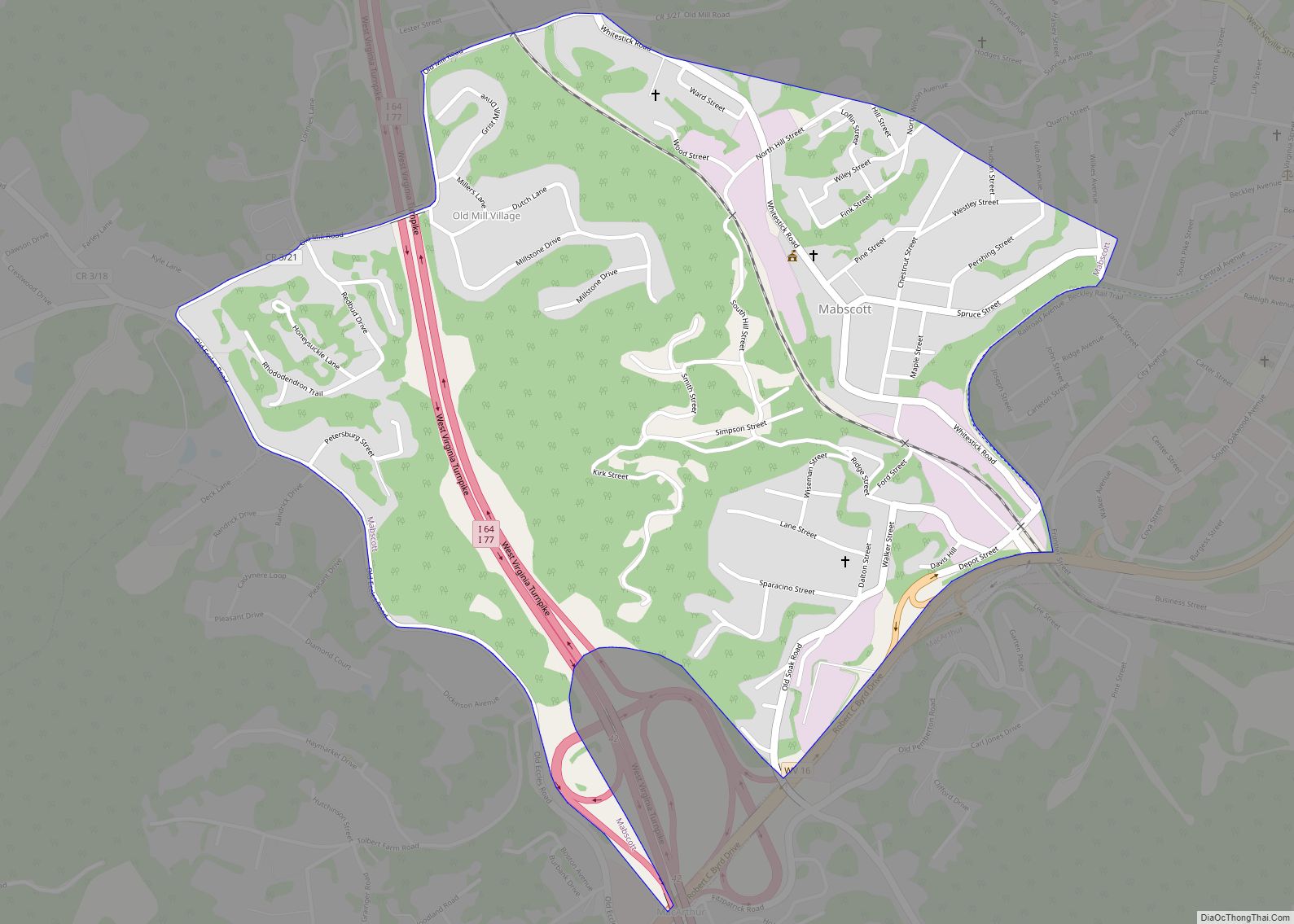
Mabscott is a town in Raleigh County, West Virginia, United States. The population was 1,333 at the 2020 census. The town’s name is a contraction of the name Mabel Scott, wife of local coal operator Cyrus H. Scott. Mabscott town overview: Name: Mabscott town LSAD Code: 43 LSAD Description: town (suffix) State: West Virginia County: ... Read more
Map of Mabscott town
Map of McConnell CDP
McConnell is an unincorporated community and census-designated place (CDP) in Logan County, West Virginia, United States, on the Guyandotte River. As of the 2010 census, its population was 514. It was established in 1933. The community was named after one Mr. McConnell, a railroad promoter. McConnell CDP overview: Name: McConnell CDP LSAD Code: 57 LSAD ... Read more
Map of McConnell CDP
Map of Maybeury CDP
Maybeury is a census-designated place (CDP) in McDowell County, West Virginia, United States, located on U.S. Route 52 between Northfork and Bramwell. As of the 2010 census, its population was 234. Maybeury was built by Shamokin Coal & Coke Co. circa 1890, and it was named for coal operators James May and William Beury. Maybeury ... Read more
Map of Maybeury CDP
Map of Lubeck CDP
Lubeck is a census-designated place (CDP) in Wood County, West Virginia, United States. It is part of the Parkersburg–Marietta–Vienna, WV-OH Metropolitan Statistical Area. The population was 1,311 at the 2010 census. Though first named Watertown, postmaster Theodore Frederick Henry Slevogt in 1856 changed the name to Lubeck after his hometown in Germany. Lubeck CDP overview: ... Read more
Map of Lubeck CDP
Map of Matoaka town
Matoaka is a census-designated place in Mercer County, West Virginia, United States. The population was 227 at the 2010 census. It is part of the Bluefield, WV-VA micropolitan area which has a population of 107,578. This town is named for Chief Powhatan’s daughter Matoaka who was better known by her nickname “Pocahontas”. Matoaka became an ... Read more
Map of Matoaka town
Map of Montrose town, West Virginia
Montrose is a town in Randolph County, West Virginia, United States. The population was 141 at the 2020 census. The town was so named on account of wild rose bushes near the original town site. Montrose town overview: Name: Montrose town LSAD Code: 43 LSAD Description: town (suffix) State: West Virginia County: Randolph County Elevation: ... Read more
Map of Montrose town, West Virginia
Map of Montgomery city, West Virginia
Montgomery is a city in West Virginia, along the Kanawha River. Most of the city is in Fayette County, with the remainder in Kanawha County. The population was 1,280 at the 2020 census. From 1876 to 1890, the town was called Coal Valley Post Office. The name then changed to Montgomery’s Landing, then to Coal ... Read more
Map of Montgomery city, West Virginia
Map of Montcalm CDP
Montcalm is a census-designated place (CDP) in Mercer County, West Virginia, United States. The population was 726 at the 2010 census. It is part of the Bluefield, WV-VA micropolitan area which has a population of 107,342. Residents of Montcalm are called Montcalmers. Montcalm CDP overview: Name: Montcalm CDP LSAD Code: 57 LSAD Description: CDP (suffix) ... Read more
Map of Montcalm CDP
Map of Monaville CDP
Monaville is an unincorporated community and census-designated place (CDP) in Logan County, West Virginia, United States. As of the 2010 census, its population was 309. Monaville CDP overview: Name: Monaville CDP LSAD Code: 57 LSAD Description: CDP (suffix) State: West Virginia County: Logan County Elevation: 712 ft (217 m) Total Area: 0.464 sq mi (1.20 km²) Land Area: 0.457 sq mi (1.18 km²) ... Read more
Map of Monaville CDP
Map of Mitchell Heights town
Mitchell Heights is a town in Logan County, West Virginia, United States. The population was 315 at the 2020 census. The town was named for an early farm on which it was established. Mitchell Heights town overview: Name: Mitchell Heights town LSAD Code: 43 LSAD Description: town (suffix) State: West Virginia County: Logan County Elevation: ... Read more
Map of Mitchell Heights town
Map of Neibert CDP
Neibert is an unincorporated community and census-designated place (CDP) in Logan County, West Virginia, United States. Its population was 183 as of the 2010 census. Neibert CDP overview: Name: Neibert CDP LSAD Code: 57 LSAD Description: CDP (suffix) State: West Virginia County: Logan County Elevation: 718 ft (219 m) Total Area: 0.630 sq mi (1.63 km²) Land Area: 0.612 sq mi (1.59 km²) ... Read more
Map of Neibert CDP
Map of Middleway CDP
Middleway is a census-designated place (CDP) in Jefferson County, West Virginia, United States, in the lower Shenandoah Valley. As of the 2010 census, its population was 441. Middleway CDP overview: Name: Middleway CDP LSAD Code: 57 LSAD Description: CDP (suffix) State: West Virginia County: Jefferson County Total Area: 1.123 sq mi (2.91 km²) Land Area: 1.123 sq mi (2.91 km²) Water ... Read more
Map of Middleway CDP