Map of Ten Sleep town
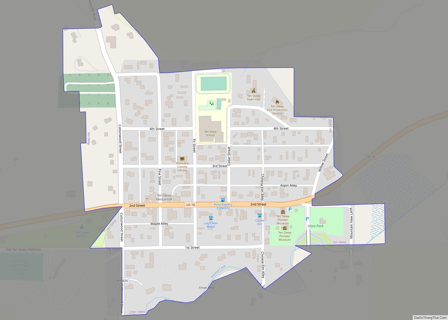
Ten Sleep is a town in Washakie County, Wyoming, United States. It is located in the Bighorn Basin in the western foothills of the Bighorn Mountains, approximately 26 miles (42 km) east of Worland and 59 miles (95 km) west of Buffalo. The population was 206 at the 2020 census. Ten Sleep town overview: Name: Ten Sleep ... Read more
Map of Ten Sleep town
Map of Saratoga town, Wyoming
Saratoga is a town in Carbon County, Wyoming, United States. The population was 1,690 at the 2010 census. Saratoga is the home of the Steinley Cup microbrew festival and competition, usually held in August at Veterans Island Park, a playground and picnic facility on a small island in the North Platte River, which is designated ... Read more
Map of Saratoga town, Wyoming
Map of Taylor CDP, Wyoming
Taylor is a census-designated place (CDP) in Lincoln County, Wyoming, United States. The population was 90 at the 2010 census. Taylor CDP overview: Name: Taylor CDP LSAD Code: 57 LSAD Description: CDP (suffix) State: Wyoming County: Lincoln County Total Area: 2.6 sq mi (6.6 km²) Land Area: 2.6 sq mi (6.6 km²) Water Area: 0.0 sq mi (0.0 km²) Total Population: 90 Population Density: ... Read more
Map of Taylor CDP, Wyoming
Map of Ryan Park CDP
Ryan Park is a census-designated place (CDP) in Carbon County, Wyoming, United States, that is located within the Medicine Bow–Routt National Forest. “Ryan Park” is designated as an acceptable place name by the United States Postal Service for mailing addresses and is assigned the ZIP code (82331) of Saratoga, the nearest incorporated town. The population ... Read more
Map of Ryan Park CDP
Map of Table Rock CDP, Wyoming
Table Rock is a ghost town in Sweetwater County, Wyoming, United States. It was also part of a census-designated place at the 2000 census, with a population of 82, but by the 2010 census the population had dropped to 0. Table Rock CDP overview: Name: Table Rock CDP LSAD Code: 57 LSAD Description: CDP (suffix) ... Read more
Map of Table Rock CDP, Wyoming
Map of Superior town, Wyoming
Superior is a town in Sweetwater County, Wyoming, United States. The population was 336 at the 2010 census. Superior town overview: Name: Superior town LSAD Code: 43 LSAD Description: town (suffix) State: Wyoming County: Sweetwater County Elevation: 7,070 ft (2,150 m) Total Area: 1.12 sq mi (2.90 km²) Land Area: 1.12 sq mi (2.90 km²) Water Area: 0.00 sq mi (0.00 km²) Total Population: 336 Population ... Read more
Map of Superior town, Wyoming
Map of Sundance town
Sundance (Lakota: Owíwaŋyaŋg Wačhí; “Sun-watching Dance”) is a town in and the county seat of Crook County, Wyoming, United States. Its population was 1,032 at the 2020 census. The town is named after the Sun Dance ceremony practiced by several American Indian tribes. Sundance town overview: Name: Sundance town LSAD Code: 43 LSAD Description: town ... Read more
Map of Sundance town
Map of Wamsutter town
Wamsutter is a town in Sweetwater County, Wyoming, United States. The population was 203 at the 2020 census. The original inhabitants of the area were the Shoshone and Ute tribes. Westerners only began to settle in the county with the coming of the railroad in the 1860s. Originally, the town was known as Washakie. Confusion ... Read more
Map of Wamsutter town
Map of Vista West CDP
Vista West is a census-designated place (CDP) in Natrona County, Wyoming, United States. It is part of the Casper, Wyoming Metropolitan Statistical Area. The population was 951 at the 2010 census. Vista West CDP overview: Name: Vista West CDP LSAD Code: 57 LSAD Description: CDP (suffix) State: Wyoming County: Natrona County Total Area: 4.8 sq mi (12 km²) ... Read more
Map of Vista West CDP
Map of Veteran CDP
Veteran is a census-designated place (CDP) located in Goshen County, Wyoming, United States. The population was 23 at the 2010 census. Veteran CDP overview: Name: Veteran CDP LSAD Code: 57 LSAD Description: CDP (suffix) State: Wyoming County: Goshen County Elevation: 4,239 ft (1,292 m) Total Area: 1.3 sq mi (3.5 km²) Land Area: 1.3 sq mi (3.5 km²) Water Area: 0.0 sq mi (0.0 km²) Total ... Read more
Map of Veteran CDP
Map of Van Tassell town
Van Tassell is a town in Niobrara County, Wyoming, United States. The population was 15 at the 2010 census. It is the least populous town in the least populous county of the least populous state in the U.S. Van Tassell town overview: Name: Van Tassell town LSAD Code: 43 LSAD Description: town (suffix) State: Wyoming ... Read more
Map of Van Tassell town
Map of Urie CDP
Urie is a census-designated place in Uinta County, Wyoming, United States. The population was 262 at the 2010 census. The main roads that run through the community are Interstate 80 Business Loop and Wyoming Highway 414. Urie CDP overview: Name: Urie CDP LSAD Code: 57 LSAD Description: CDP (suffix) State: Wyoming County: Uinta County Elevation: ... Read more
Map of Urie CDP