Map of Clinton CDP, Washington
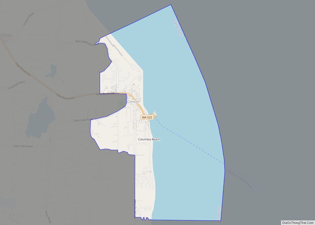
Clinton is a community and census-designated place (CDP) located on southern Whidbey Island in Island County, Washington, United States. The town was named after Clinton, Michigan. As of the 2010 census, the village was 928. However, the post office serves at least 2,500 people. Clinton is the western terminus of the Whidbey Island (Clinton)-to-Mukilteo Washington ... Read more
Map of Clinton CDP, Washington
Map of Cliffdell CDP
Cliffdell is an unincorporated community in Yakima County, Washington, United States, located approximately 23 miles west of Ellensburg. The community was originally named Spring Flats and in 1920, was renamed to Cliffdell in honor of Cliff and Della Schott of Seattle. The Schott’s were friends of homesteader Russell Davison who developed much of the town ... Read more
Map of Cliffdell CDP
Map of Cosmopolis city
Cosmopolis is a city in Grays Harbor County, Washington, United States. The population was 1,638 at the 2020 census. Cosmopolis city overview: Name: Cosmopolis city LSAD Code: 25 LSAD Description: city (suffix) State: Washington County: Grays Harbor County Elevation: 26 ft (8 m) Land Area: 1.39 sq mi (3.60 km²) Water Area: 0.19 sq mi (0.49 km²) Population Density: 1,193.97/sq mi (461.05/km²) ZIP code: ... Read more
Map of Cosmopolis city
Map of Copalis Beach CDP
Copalis Beach is a census-designated place (CDP) in Grays Harbor County, Washington, United States. The population was 415 at the 2010 census. The name “Copalis” comes from the Quinault language term /k’ʷpíls/. The Copalis are a Native American group. Both the Chehalis people and Quinault Indian Nation claim the Copalis are a subdivision of their ... Read more
Map of Copalis Beach CDP
Map of Conway CDP, Washington
Conway is a census-designated place (CDP) in Skagit County, Washington, United States. First settled in 1873 by Thomas P. Jones and Charles Villeneuves, its population was 91 at the 2010 census. It is included in the Mount Vernon–Anacortes, Washington Metropolitan Statistical Area. Conway CDP overview: Name: Conway CDP LSAD Code: 57 LSAD Description: CDP (suffix) ... Read more
Map of Conway CDP, Washington
Map of Connell city
Connell (/kɑːˈnɛl/) is a city in Franklin County, Washington, United States. The population was 5,441 at the 2020 census. Connell city overview: Name: Connell city LSAD Code: 25 LSAD Description: city (suffix) State: Washington County: Franklin County Elevation: 846 ft (258 m) Total Area: 7.69 sq mi (19.91 km²) Land Area: 7.69 sq mi (19.91 km²) Water Area: 0.00 sq mi (0.00 km²) Total Population: 5,441 ... Read more
Map of Connell city
Map of Concrete town
Concrete town overview: Name: Concrete town LSAD Code: 43 LSAD Description: town (suffix) State: Washington County: Skagit County FIPS code: 5314380 Online Interactive Map Concrete online map. Source: Basemap layers from Google Map, Open Street Map (OSM), Arcgisonline, Wmflabs. Boundary Data from Database of Global Administrative Areas. Concrete location map. Where is Concrete town? Concrete ... Read more
Map of Concrete town
Map of Conconully town
Conconully town overview: Name: Conconully town LSAD Code: 43 LSAD Description: town (suffix) State: Washington County: Okanogan County FIPS code: 5314310 Online Interactive Map Conconully online map. Source: Basemap layers from Google Map, Open Street Map (OSM), Arcgisonline, Wmflabs. Boundary Data from Database of Global Administrative Areas. Conconully location map. Where is Conconully town? Conconully ... Read more
Map of Conconully town
Map of Colville city
Colville is a city in Stevens County, Washington, United States. The population was 4,673 at the 2010 census. It is the county seat of Stevens County. Colville city overview: Name: Colville city LSAD Code: 25 LSAD Description: city (suffix) State: Washington County: Stevens County Elevation: 1,614 ft (492 m) Land Area: 3.08 sq mi (7.99 km²) Water Area: 0.00 sq mi (0.00 km²) ... Read more
Map of Colville city
Map of Coulee City town
Coulee City town overview: Name: Coulee City town LSAD Code: 43 LSAD Description: town (suffix) State: Washington County: Grant County FIPS code: 5315080 Online Interactive Map Coulee City online map. Source: Basemap layers from Google Map, Open Street Map (OSM), Arcgisonline, Wmflabs. Boundary Data from Database of Global Administrative Areas. Coulee City location map. Where ... Read more
Map of Coulee City town
Map of Curlew CDP, Washington
Curlew is an unincorporated community and census-designated place (CDP) located in northwestern Ferry County, Washington, United States, between Malo and Danville on State Route 21. The BNSF Railway ran through the town. The historic Ansorge Hotel is located in Curlew. As of the 2010 census, the population of the community was 118. The settlement is ... Read more
Map of Curlew CDP, Washington
Map of Curlew Lake CDP
Curlew Lake is a census-designated place (CDP) in Ferry County, Washington. Curlew Lake CDP overview: Name: Curlew Lake CDP LSAD Code: 57 LSAD Description: CDP (suffix) State: Washington County: Ferry County Elevation: 2,356 ft (718 m) Total Area: 5.7 sq mi (14.8 km²) Land Area: 4.4 sq mi (11.3 km²) Water Area: 1.4 sq mi (3.5 km²) Total Population: 462 Population Density: 106/sq mi (40.9/km²) Area code: ... Read more
Map of Curlew Lake CDP