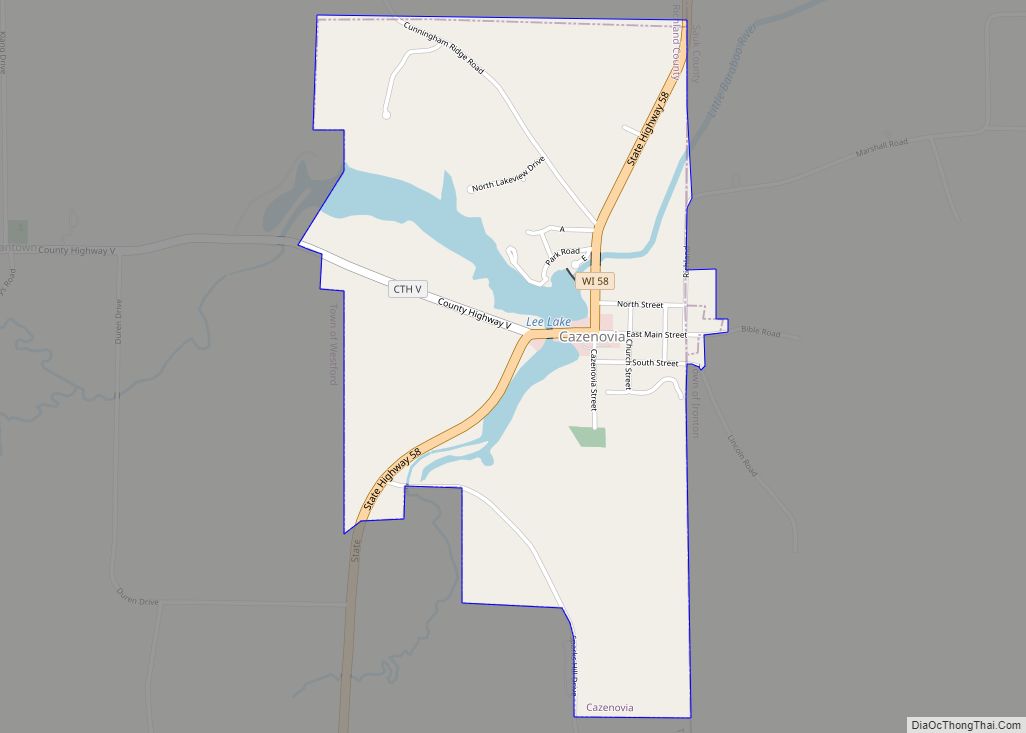
Map of Mallory CDP

Map of Mallory CDP

Mallory is a census-designated place (CDP) in Logan County, West Virginia, United States. The population was 1,654 at the 2010 census. The CDP contains the unincorporated communities, from west to east, of Huff Junction, Mallory, Davin, Mineral City, Claypool, Combs Addition, and Gillman Bottom. The community was named after the local Mallory Coal Company. Mallory … Read more

Map of Mullens city

Map of Mullens city

Mullens is a city in Wyoming County, West Virginia. The population was 1,475 at the time of the 2020 census. It is home to a highly rated railroad themed restaurant “Second Street”, and has a railroad crossing at the front entry of the town. Located in a valley along the Guyandotte River within a mountainous … Read more

Map of Middlebourne town

Map of Middlebourne town

Middlebourne is a town in Tyler County, West Virginia, United States. The population was 715 at the 2020 census. It serves as the county seat of Tyler County. Middlebourne town overview: Name: Middlebourne town LSAD Code: 43 LSAD Description: town (suffix) State: West Virginia County: Tyler County Elevation: 735 ft (224 m) Total Area: 0.38 sq mi (0.98 km²) Land … Read more

Map of Mount Hope city, West Virginia

Map of Mount Hope city, West Virginia

Mount Hope is a city in Fayette County, West Virginia, United States. The population was 1,414 at the 2010 census. Mount Hope city overview: Name: Mount Hope city LSAD Code: 25 LSAD Description: city (suffix) State: West Virginia County: Fayette County Elevation: 1,722 ft (525 m) Total Area: 1.56 sq mi (4.03 km²) Land Area: 1.56 sq mi (4.03 km²) Water Area: 0.00 sq mi … Read more

Map of Meadow Bridge town

Map of Meadow Bridge town

Meadow Bridge is a town in Fayette County, West Virginia, United States. The population was 379 at the 2010 census. The first settler of the area was John Gwin, closely followed by Dan Griffin. The community took its name from a nearby bridge over Meadow Creek. Meadow Bridge town overview: Name: Meadow Bridge town LSAD … Read more

Map of Mount Gay-Shamrock CDP

Map of Mount Gay-Shamrock CDP

Mount Gay-Shamrock is a census-designated place (CDP) in Logan County, West Virginia, United States. Mount Gay-Shamrock has a 2020 population of 1,360. Mount Gay-Shamrock is currently declining at a rate of -2.51% annually. The population was 1,779 at the 2010 census. The CDP includes the unincorporated communities of Mount Gay, Shamrock, Black Bottom, Whites Addition, … Read more

Map of McMechen city

Map of McMechen city

McMechen is a city in Marshall County, West Virginia, United States, situated along the Ohio River. It is part of the Wheeling, West Virginia Metropolitan Statistical Area. The population was 1,714 at the 2020 census. McMechen city overview: Name: McMechen city LSAD Code: 25 LSAD Description: city (suffix) State: West Virginia County: Marshall County Elevation: … Read more

Map of Mount Carbon CDP, West Virginia

Map of Mount Carbon CDP, West Virginia

Mount Carbon is a census-designated place (CDP) in Fayette County, West Virginia, United States. Mount Carbon is located along West Virginia Route 61, 3 miles (4.8 km) southeast of Montgomery, on the south bank of the Kanawha River at the mouth of Armstrong Creek. Mount Carbon has a post office with ZIP code 25139. As of … Read more

Map of Moundsville city

Map of Moundsville city

Moundsville is a city in and the county seat of Marshall County, West Virginia, United States, along the Ohio River. The population was 8,122 at the 2020 census. It is part of the Wheeling metropolitan area. The city was named for the nearby ancient Grave Creek Mound, constructed 250 to 100 BC by indigenous people … Read more

Map of Moorefield town, West Virginia

Map of Moorefield town, West Virginia

Moorefield is a town and the county seat of Hardy County, West Virginia, United States. It is located at the confluence of the South Branch Potomac River and the South Fork South Branch Potomac River. Moorefield was originally chartered in 1777; it was named for Conrad Moore, who owned the land upon which the town … Read more

Map of Montrose town, West Virginia

Map of Montrose town, West Virginia

Montrose is a town in Randolph County, West Virginia, United States. The population was 141 at the 2020 census. The town was so named on account of wild rose bushes near the original town site. Montrose town overview: Name: Montrose town LSAD Code: 43 LSAD Description: town (suffix) State: West Virginia County: Randolph County Elevation: … Read more

Map of Montgomery city, West Virginia

Map of Montgomery city, West Virginia

Montgomery is a city in West Virginia, along the Kanawha River. Most of the city is in Fayette County, with the remainder in Kanawha County. The population was 1,280 at the 2020 census. From 1876 to 1890, the town was called Coal Valley Post Office. The name then changed to Montgomery’s Landing, then to Coal … Read more