Map of Chain O’ Lakes CDP
Chain O’ Lakes is a census-designated place in the towns of Farmington and Dayton, Waupaca County, Wisconsin, United States. Its population was 981 as of the 2010 census. Before 2010, it was part of the Chain O’ Lakes-King CDP. It consists of twenty-two lakes connected by channels, natural openings, and creeks. In the Menominee language, ... Read more
Map of Chain O’ Lakes CDP
Map of Clintonville city, Wisconsin
Clintonville is a city in Waupaca County, Wisconsin, United States. The population was 4,591 at the 2020 census. The area that became Clintonville was first settled in March, 1855. Clintonville city overview: Name: Clintonville city LSAD Code: 25 LSAD Description: city (suffix) State: Wisconsin County: Waupaca County Elevation: 814 ft (248 m) Total Area: 4.54 sq mi (11.76 km²) Land ... Read more
Map of Clintonville city, Wisconsin
Map of Cedarburg city
Cedarburg is a city in Ozaukee County, Wisconsin, United States. Located about 20 miles (32 km) north of Milwaukee and in close proximity to Interstate 43, it is a suburban community in the Milwaukee metropolitan area. The city incorporated in 1885, and at the time of the 2020 census the population was 12,121. Like many of ... Read more
Map of Cedarburg city
Map of Cleveland village, Wisconsin
Cleveland is a village in Manitowoc County, Wisconsin, United States. The population was 1,485 at the 2010 census. Cleveland village overview: Name: Cleveland village LSAD Code: 47 LSAD Description: village (suffix) State: Wisconsin County: Manitowoc County Total Area: 1.98 sq mi (5.13 km²) Land Area: 1.98 sq mi (5.12 km²) Water Area: 0.01 sq mi (0.01 km²) Total Population: 1,485 Population Density: 736.20/sq mi (284.22/km²) ... Read more
Map of Cleveland village, Wisconsin
Map of Clam Lake CDP
Clam Lake is an unincorporated, census-designated place in the town of Gordon in Ashland County, Wisconsin, United States. It is located on Wisconsin Highway 77 near County Highway GG. The entire area lies within the Chequamegon National Forest, an 860,000 acre area spread across northern Wisconsin. As of the 2010 census, its population was 37. ... Read more
Map of Clam Lake CDP
Map of Chippewa Falls city
Chippewa Falls is a city located on the Chippewa River in Chippewa County in the northwestern part of the U.S. state of Wisconsin. The population was 14,778 in the 2021 census. Incorporated as a city in 1869, it is the county seat of Chippewa County. The city’s name originated from its location on the Chippewa ... Read more
Map of Chippewa Falls city
Map of Chilton city, Wisconsin
Chilton is a city in and county seat of Calumet County in the U.S. state of Wisconsin. The population was 4,080 at the 2020 census. The city is partially within the Town of Chilton. Chilton city overview: Name: Chilton city LSAD Code: 25 LSAD Description: city (suffix) State: Wisconsin County: Calumet County Elevation: 902 ft (275 m) ... Read more
Map of Chilton city, Wisconsin
Map of Chief Lake CDP
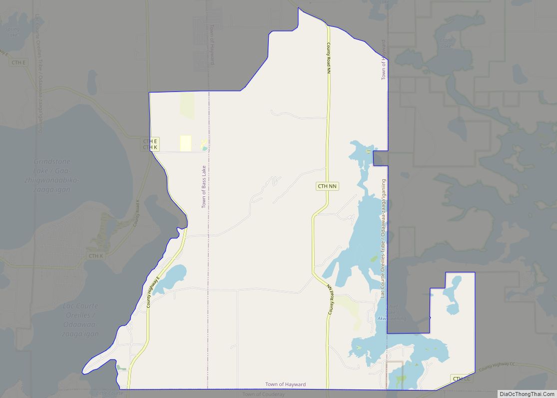
Chief Lake is a census-designated place (CDP) in the town of Hayward, Sawyer County, Wisconsin, United States. The population was 583 at the 2010 census. Chief Lake CDP overview: Name: Chief Lake CDP LSAD Code: 57 LSAD Description: CDP (suffix) State: Wisconsin County: Sawyer County Elevation: 1,339 ft (408 m) Total Area: 23.6 sq mi (61.2 km²) Land Area: 21.1 sq mi ... Read more
Map of Chief Lake CDP
Map of Cudahy city, Wisconsin
Cudahy (/ˈkʌdəheɪ/) is a city in Milwaukee County, Wisconsin, United States. The population was 18,204 at the 2020 census. Cudahy city overview: Name: Cudahy city LSAD Code: 25 LSAD Description: city (suffix) State: Wisconsin County: Milwaukee County Elevation: 722 ft (220 m) Total Area: 4.77 sq mi (12.36 km²) Land Area: 4.77 sq mi (12.36 km²) Water Area: 0.00 sq mi (0.00 km²) Total Population: 18,204 ... Read more
Map of Cudahy city, Wisconsin
Map of Colfax village, Wisconsin
Colfax is a town in Dunn County, Wisconsin, United States. The population was 909 at the 2000 census. Colfax village overview: Name: Colfax village LSAD Code: 47 LSAD Description: village (suffix) State: Wisconsin County: Dunn County FIPS code: 5516275 Online Interactive Map Colfax online map. Source: Basemap layers from Google Map, Open Street Map (OSM), ... Read more
Map of Colfax village, Wisconsin
Map of Cuba City
Cuba City is a city partly in Grant County and partly in Lafayette County in the U.S. state of Wisconsin. The population was 2,086 at the 2010 census. Of this, 1,877 were in Grant County, and 209 were in Lafayette County. The city is nicknamed “The City of Presidents” because of the presidential banners displayed ... Read more
Map of Cuba City
Map of Cross Plains village, Wisconsin
Cross Plains is a town in Dane County, Wisconsin, United States. The population was 1,419 at the 2000 census. The Village of Cross Plains is located partially within the town. The unincorporated community of Pine Bluff is located in the town. Cross Plains village overview: Name: Cross Plains village LSAD Code: 47 LSAD Description: village ... Read more
Map of Cross Plains village, Wisconsin