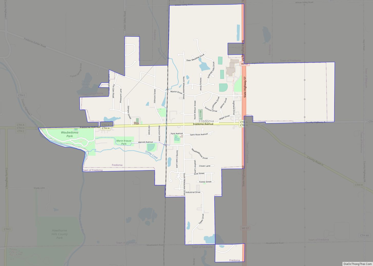
Map of Shady Spring CDP

Map of Shady Spring CDP

Shady Spring is a census-designated place (CDP) in Raleigh County, West Virginia, United States. The population was 2,998 at the 2010 census. It is a residential community, with a low crime rate. Shady Spring is close to the Resort at Glade Springs, Flat Top Lake, Winterplace Ski Resort, and the city of Beckley. Shady Spring … Read more

Map of Scarbro CDP

Map of Scarbro CDP

Scarbro is a census-designated place (CDP) and coal town in Fayette County, West Virginia, United States. Scarbro is 1.5 miles (2.4 km) southwest of Oak Hill. Scarbro has a post office with ZIP code 25917. As of the 2010 census, its population was 486. The community was named for the fact a large share of the … Read more

Map of Sarah Ann CDP

Map of Sarah Ann CDP

Sarah Ann is a census-designated place (CDP) in Logan County, West Virginia, United States. The CDP includes the unincorporated community of Sarah Ann, plus the neighboring communities of Crystal Block and part of Stirrat. As of the 2010 census, the population of the CDP was 345. Sarah Ann CDP overview: Name: Sarah Ann CDP LSAD … Read more

Map of Sand Fork town

Map of Sand Fork town

Sand Fork is a town in Gilmer County, West Virginia, United States. The population was 182 at the 2020 census. It is located along the Little Kanawha River, at the mouth of the Sand Fork. Sand Fork was incorporated in 1903 as Layopolis, named for William R. Lay, an employee of the Eureka Pipe Line … Read more

Map of Salt Rock CDP

Map of Salt Rock CDP

Salt Rock (also Saltrock) is a census-designated place (CDP) in southern Cabell County, West Virginia, United States. As of the 2010 census, its population was 388. It lies along West Virginia Route 10 southeast of the city of Huntington, the county seat of Cabell County. Its elevation is 581 feet (177 m). Although Salt Rock is unincorporated, … Read more

Map of Salem city, West Virginia

Map of Salem city, West Virginia

Salem is a city in Harrison County, West Virginia, United States. The population was 1,485 at the 2020 census. It is located at the junction of U.S. Route 50 and West Virginia Route 23; the North Bend Rail Trail passes through the city. Salem University is located in Salem. Salem city overview: Name: Salem city … Read more

Map of Rupert town, West Virginia

Map of Rupert town, West Virginia

Rupert is a town in Greenbrier County, West Virginia, United States. The population was 881 at the 2020 census. Rupert town overview: Name: Rupert town LSAD Code: 43 LSAD Description: town (suffix) State: West Virginia County: Greenbrier County Elevation: 2,425 ft (739 m) Total Area: 0.78 sq mi (2.03 km²) Land Area: 0.77 sq mi (1.99 km²) Water Area: 0.01 sq mi (0.04 km²) Total Population: … Read more

Map of Rowlesburg town

Map of Rowlesburg town

Rowlesburg is a town in southern Preston County, West Virginia, United States, along the Cheat River. The population was 438 at the 2020 census. It is part of the Morgantown metropolitan area. A former railroad town, it is home to the Downtown Rowlesburg Historic District, and was the site of action during the American Civil … Read more

Map of Rossmore CDP

Map of Rossmore CDP

Rossmore is an unincorporated community and census-designated place (CDP) in Logan County, West Virginia, United States, along West Virginia Route 44 and Island Creek. Its population was 301 as of the 2010 census. Rossmore CDP overview: Name: Rossmore CDP LSAD Code: 57 LSAD Description: CDP (suffix) State: West Virginia County: Logan County Elevation: 728 ft (222 m) … Read more

Map of Ronceverte city

Map of Ronceverte city

Ronceverte is a city in Greenbrier County, West Virginia, United States, on the Greenbrier River. The population was 1,572 at the 2020 census. Ronceverte city overview: Name: Ronceverte city LSAD Code: 25 LSAD Description: city (suffix) State: West Virginia County: Greenbrier County Incorporated: 1882 Elevation: 1,723 ft (525 m) Total Area: 1.73 sq mi (4.48 km²) Land Area: 1.70 sq mi (4.41 km²) … Read more

Map of Sissonville CDP

Map of Sissonville CDP

Sissonville is a census-designated place (CDP) in Kanawha County, West Virginia, United States, along the Pocatalico River. The population was 4,028 at the 2010 census. Sissonville is located within 14 miles of Charleston, the state capital. Sissonville CDP overview: Name: Sissonville CDP LSAD Code: 57 LSAD Description: CDP (suffix) State: West Virginia County: Kanawha County … Read more

Map of Romney city

Map of Romney city

Romney is a town in and the county seat of Hampshire County, West Virginia, United States. The population was 1,722 at the 2020 census. It is part of the Winchester, Virginia metropolitan area. Established in 1762 along with Shepherdstown, they are the oldest towns in West Virginia. Romney city overview: Name: Romney city LSAD Code: … Read more