Map of Greenfield city, Wisconsin
Greenfield is a city in the U.S. state of Wisconsin. Located in Milwaukee County, Greenfield is one of many bedroom communities in the Milwaukee metropolitan area. The population was 37,803 as of the 2020 Census. Greenfield city overview: Name: Greenfield city LSAD Code: 25 LSAD Description: city (suffix) State: Wisconsin County: Milwaukee County Elevation: 794 ft ... Read more
Map of Greenfield city, Wisconsin
Map of Haugen village
Haugen (/ˈhɑːɡən/ HAH-gən) is a village in Barron County in the U.S. state of Wisconsin. The population was 287 at the 2010 census. Haugen village overview: Name: Haugen village LSAD Code: 47 LSAD Description: village (suffix) State: Wisconsin County: Barron County Elevation: 1,230 ft (375 m) Total Area: 0.51 sq mi (1.32 km²) Land Area: 0.50 sq mi (1.31 km²) Water Area: 0.01 sq mi ... Read more
Map of Haugen village
Map of Hartland village, Wisconsin
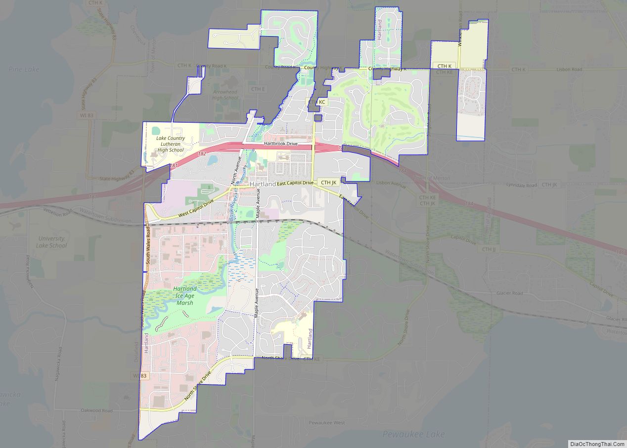
Hartland is a village along the Bark River in Waukesha County, Wisconsin, United States, that is a suburb of Milwaukee. The population was 9,501 at the 2020 census. Hartland village overview: Name: Hartland village LSAD Code: 47 LSAD Description: village (suffix) State: Wisconsin County: Waukesha County Elevation: 935 ft (285 m) Total Area: 5.51 sq mi (14.27 km²) Land Area: ... Read more
Map of Hartland village, Wisconsin
Map of Hartford city, Wisconsin
Hartford is a city in Washington and Dodge counties in the U.S. state of Wisconsin. As of the 2010 census, the city had a population of 14,223. All of this population resided in the Washington County portion of the city. The portion of the city in Dodge County consists of only industrial/commercial parcels. Located approximately ... Read more
Map of Hartford city, Wisconsin
Map of Hancock village, Wisconsin
Hancock is a village in Waushara County, Wisconsin, United States. The population was 417 at the 2010 census. The village is located within the Town of Hancock. Hancock village overview: Name: Hancock village LSAD Code: 47 LSAD Description: village (suffix) State: Wisconsin County: Waushara County Elevation: 1,086 ft (331 m) Total Area: 1.05 sq mi (2.71 km²) Land Area: 1.05 sq mi ... Read more
Map of Hancock village, Wisconsin
Map of Hammond village, Wisconsin
Hammond is a town in St. Croix County, Wisconsin, United States. The population was 947 at the 2000 census. The Village of Hammond is located within the town. Hammond village overview: Name: Hammond village LSAD Code: 47 LSAD Description: village (suffix) State: Wisconsin County: St. Croix County FIPS code: 5532325 Online Interactive Map Hammond online ... Read more
Map of Hammond village, Wisconsin
Map of Hales Corners village
Hales Corners is a village in Milwaukee County, Wisconsin, United States. The population was 7,720 at the 2020 census. Hales Corners village overview: Name: Hales Corners village LSAD Code: 47 LSAD Description: village (suffix) State: Wisconsin County: Milwaukee County Elevation: 781 ft (238 m) Total Area: 3.20 sq mi (8.28 km²) Land Area: 3.19 sq mi (8.27 km²) Water Area: 0.01 sq mi (0.02 km²) Total ... Read more
Map of Hales Corners village
Map of Hager City CDP
Hager City is an unincorporated census-designated place located in the town of Trenton in Pierce County, Wisconsin, United States, across the Mississippi River from Red Wing, Minnesota. It is located near the intersection of State Highway 35 and U.S. Route 63. Hager City is served by the Ellsworth School District. As of the 2010 census, ... Read more
Map of Hager City CDP
Map of Hobart village, Wisconsin
Hobart is a village in Brown County in the U.S. state of Wisconsin. The population was over 10,000 at the 2020 census. Hobart is a part of the Green Bay Metropolitan Statistical Area. The village is located entirely within the former treaty boundaries of the Oneida Nation of Wisconsin. Hobart village overview: Name: Hobart village ... Read more
Map of Hobart village, Wisconsin
Map of Hewitt village, Wisconsin
Hewitt is a village in Wood County, Wisconsin, United States. The population was 828 at the 2010 census. Hewitt village overview: Name: Hewitt village LSAD Code: 47 LSAD Description: village (suffix) State: Wisconsin County: Wood County Total Area: 0.93 sq mi (2.41 km²) Land Area: 0.93 sq mi (2.41 km²) Water Area: 0.00 sq mi (0.00 km²) Total Population: 828 Population Density: 835.66/sq mi (322.71/km²) ... Read more
Map of Hewitt village, Wisconsin
Map of Howards Grove village
Howards Grove is a village in Sheboygan County, Wisconsin, United States. The population was 3,237 at the 2020 census. It is part of the Sheboygan, Wisconsin Metropolitan Statistical Area. Howards Grove village overview: Name: Howards Grove village LSAD Code: 47 LSAD Description: village (suffix) State: Wisconsin County: Sheboygan County Elevation: 712 ft (217 m) Total Area: 2.25 sq mi ... Read more
Map of Howards Grove village
Map of Ixonia CDP
Ixonia is a census-designated place (CDP) in the town of Ixonia, Jefferson County, Wisconsin, United States. The population was 2,367 at the 2020 census. Ixonia CDP overview: Name: Ixonia CDP LSAD Code: 57 LSAD Description: CDP (suffix) State: Wisconsin County: Jefferson County Elevation: 856 ft (261 m) Total Area: 3.640 sq mi (9.43 km²) Land Area: 3.638 sq mi (9.42 km²) Water Area: ... Read more
Map of Ixonia CDP