Map of Riverbank city
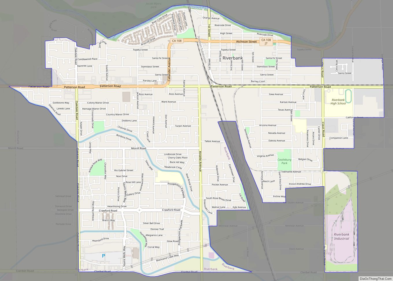
Riverbank is a city in Stanislaus County, California, United States. The population was 24,623 at the 2020 census, up from 15,826 at the 2000 census. Incorporated on August 23, 1922, Riverbank’s official slogan is “City of Action.” It is part of the Modesto Metropolitan Statistical Area. Riverbank was founded as a ferry crossing, and was ... Read more
Map of Riverbank city
Map of River Pines CDP
River Pines is a census-designated place in Amador County, California. It is located 3 miles (4.8 km) north-northeast of Fiddletown, at an elevation of 1985 feet (605 m). A post office opened at River Pines in 1948; it has the zip code of 95675. River Pines has a population of 379 (2010 census). River Pines CDP ... Read more
Map of River Pines CDP
Map of Robinson Mill CDP
Robinson Mill (also, Robinson Mills, Robinson Ranch, Robinson Sawmill, Robinsons Mill, and Robinsons Rancho) is a census-designated place in Butte County, California. It lies at an elevation of 2654 feet (809 m). Robinson Mill’s population was 80 at the 2010 census. Robinson Mill CDP overview: Name: Robinson Mill CDP LSAD Code: 57 LSAD Description: CDP ... Read more
Map of Robinson Mill CDP
Map of Robbins CDP, California
Robbins is a census-designated place (CDP) in Sutter County, California. Robbins sits at an elevation of 23 feet (7.0 m). The ZIP Code is 95676. The community is inside area code 530. The 2010 United States census reported Robbins’s population was 222. Robbins CDP overview: Name: Robbins CDP LSAD Code: 57 LSAD Description: CDP (suffix) State: ... Read more
Map of Robbins CDP, California
Map of Riverdale CDP, California
Riverdale (formerly, Liberty Settlement) is a census-designated place (CDP) in Fresno County, California, United States. The population was 3,153 at the 2010 census, up from 2,416 at the 2000 census. Riverdale is located 23 miles (37 km) south of Fresno, at an elevation of 223 ft (68 m). Riverdale CDP overview: Name: Riverdale CDP LSAD Code: 57 LSAD ... Read more
Map of Riverdale CDP, California
Map of Rodriguez Camp CDP
Rodriguez Camp is a census-designated place (CDP) in Tulare County, California. Rodriguez Camp sits at an elevation of 456 feet (139 m). The 2020 United States census reported Rodriguez Camp’s population was 133, down from 156 at the 2010 census. Rodriguez Camp CDP overview: Name: Rodriguez Camp CDP LSAD Code: 57 LSAD Description: CDP (suffix) State: ... Read more
Map of Rodriguez Camp CDP
Map of Rodeo CDP, California
Rodeo (/roʊˈdeɪ.oʊ/; Spanish for “Cattle roundup”) is a census-designated place (CDP) located in Contra Costa County, California, in the East Bay sub-region of the San Francisco Bay Area, on the eastern shore of San Pablo Bay, 25 miles northeast of San Francisco. The population was 9,653 at the 2020 census. The town is named for ... Read more
Map of Rodeo CDP, California
Map of Rocklin city
Rocklin is a city in Placer County, California, about 22 miles (35 km) from Sacramento, and about 6.1 miles (9.8 km) northeast of Roseville in the Sacramento metropolitan area. Besides Roseville, it shares borders with Granite Bay, Loomis and Lincoln. As of the 2010 census, Rocklin’s population was 56,974. The California Department of Finance placed the 2019 ... Read more
Map of Rocklin city
Map of Rohnert Park city
Rohnert Park is a city in Sonoma County, California, United States, located approximately 50 miles (80 km) north of San Francisco. The population at the 2020 United States Census was 44,390. It is an early planned city and is the sister city of Hashimoto in Japan. Sonoma State University, part of the California State University system, ... Read more
Map of Rohnert Park city
Map of Rolling Hills CDP, California
Rolling Hills is an unincorporated community and census-designated place (CDP) in Madera County, California, United States, north of Fresno on State Route 41 (Yosemite Freeway). It lies at an elevation of 371 feet (113 m). The population was 793 at the 2020 census. Rolling Hills CDP overview: Name: Rolling Hills CDP LSAD Code: 57 LSAD Description: ... Read more
Map of Rolling Hills CDP, California
Map of Rolling Hills Estates city
Rolling Hills Estates is a city in Los Angeles County, California, United States. On the northern side of the Palos Verdes Peninsula, facing Torrance, Rolling Hills Estates is mostly residential. Incorporated in 1957, Rolling Hills Estates has many horse paths. The population was 8,067 at the 2010 census, up from 7,676 at the 2000 census. ... Read more
Map of Rolling Hills Estates city
Map of Rosamond CDP
Rosamond is a unincorporated community in Kern County, California, US, near the Los Angeles county line. Rosamond is part of Greater Los Angeles and is located in the Mojave Desert just north of Lancaster and Palmdale, two of the largest cities in Antelope Valley. As of the 2010 Census, Rosamond’s population was 18,150. For statistical ... Read more
Map of Rosamond CDP