Map of Christmas CDP
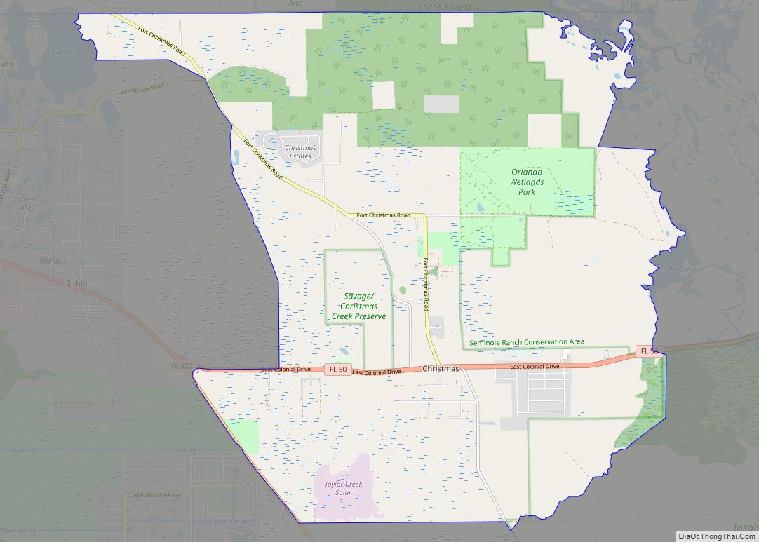
Christmas is an unincorporated area and census-designated place in Orange County, Florida, United States. It is part of the Orlando–Kissimmee Metropolitan Statistical Area. The population was 1,146 at the 2010 census. Christmas is home to the world’s largest alligator-shaped building, measuring at just over 200 feet (61 m); to Fort Christmas Historical Park, a recreation of ... Read more
Map of Christmas CDP
Map of Chokoloskee CDP
Chokoloskee is an unincorporated community and census-designated place (CDP) located at the edge of the Ten Thousand Islands in Collier County, Florida, United States. The population was 359 at the 2010 census. It is part of the Naples–Marco Island Metropolitan Statistical Area. Chokoloskee was inhabited by Native Americans for at least 1500 years before European ... Read more
Map of Chokoloskee CDP
Map of Citrus Hills CDP
Citrus Hills is a census-designated place (CDP) in Citrus County, Florida, United States. The population was 7,470 at the 2010 census, up from 4,029 in 2000. The CDP takes its name from The Villages of Citrus Hills, a master-planned community first developed by Gerald Nash and Sam Tamposi in the 1970s. (Although sharing a similar ... Read more
Map of Citrus Hills CDP
Map of Cinco Bayou town
Cinco Bayou is a town in Okaloosa County, Florida, United States. The population was 383 at the 2010 census. It is part of the Fort Walton Beach–Crestview–Destin Metropolitan Statistical Area. Cinco Bayou town overview: Name: Cinco Bayou town LSAD Code: 43 LSAD Description: town (suffix) State: Florida County: Okaloosa County Elevation: 13 ft (4 m) Total Area: ... Read more
Map of Cinco Bayou town
Map of Chumuckla CDP
Chumuckla is a census-designated place in Santa Rosa County, Florida, United States. The population of Chumuckla was 850 in the 2010 census. The population was estimated to be 863 in 2017. Chumuckla CDP overview: Name: Chumuckla CDP LSAD Code: 57 LSAD Description: CDP (suffix) State: Florida County: Santa Rosa County FIPS code: 1212300 Online Interactive ... Read more
Map of Chumuckla CDP
Map of Citrus Park CDP, Florida
Citrus Park is an unincorporated census-designated place in Hillsborough County, Florida, United States. The population was 28,178 at the 2020 census, up from 24,252 at the 2010 census. Citrus Park CDP overview: Name: Citrus Park CDP LSAD Code: 57 LSAD Description: CDP (suffix) State: Florida County: Hillsborough County Elevation: 43 ft (13 m) Total Area: 10.82 sq mi (28.02 km²) ... Read more
Map of Citrus Park CDP, Florida
Map of Clarcona CDP
Clarcona is a census-designated place and unincorporated area in Orange County, Florida, United States. The population was 2,990 at the 2010 census. It is part of the Orlando–Kissimmee Metropolitan Statistical Area. Clarcona CDP overview: Name: Clarcona CDP LSAD Code: 57 LSAD Description: CDP (suffix) State: Florida County: Orange County Elevation: 100 ft (30 m) Total Area: 4.37 sq mi ... Read more
Map of Clarcona CDP
Map of Citrus Springs CDP
Citrus Springs is a census-designated place (CDP) in Citrus County, Florida, United States. The population was 8,622 as of the 2010 census, up from 4,157 in 2000. Citrus Springs CDP overview: Name: Citrus Springs CDP LSAD Code: 57 LSAD Description: CDP (suffix) State: Florida County: Citrus County Elevation: 95 ft (29 m) Total Area: 21.15 sq mi (54.77 km²) Land ... Read more
Map of Citrus Springs CDP
Map of Clewiston city
Clewiston is a city in Hendry County, Florida, United States. Its location is 80 miles (130 km) northwest of Fort Lauderdale on the Atlantic coastal plain. The population was 7,327 at the 2020 census, up from 7,155 at the 2010 census. The estimated population in 2018 was 7,985. The city is located on the south bank ... Read more
Map of Clewiston city
Map of Cleveland CDP, Florida
Cleveland is a census-designated place (CDP) in Charlotte County, Florida, United States. The population was 3,435 at the 2020 census. It is part of the Sarasota-Bradenton-Punta Gorda Combined Statistical Area. Cleveland CDP overview: Name: Cleveland CDP LSAD Code: 57 LSAD Description: CDP (suffix) State: Florida County: Charlotte County Elevation: 7 ft (2 m) Total Area: 5.72 sq mi (14.81 km²) ... Read more
Map of Cleveland CDP, Florida
Map of Clermont city, Florida
Clermont is a city in Lake County in central Florida, United States, about 22 miles (35 km) west of Orlando and 22 miles (35 km) southeast of Leesburg. The population was 43,021 in 2020. The city is residential in character and its economy is centered in retail trade, lodging, and tourism-oriented restaurants and bars. It is part ... Read more
Map of Clermont city, Florida
Map of Cocoa Beach city
Cocoa Beach is a city in Brevard County, Florida, United States. The population was 11,539 at the 2018 United States Census. It is part of the Palm Bay–Melbourne–Titusville, Florida Metropolitan Statistical Area. Cocoa Beach city overview: Name: Cocoa Beach city LSAD Code: 25 LSAD Description: city (suffix) State: Florida County: Brevard County Elevation: 10 ft (3 m) ... Read more
Map of Cocoa Beach city