Map of Oakleaf Plantation CDP
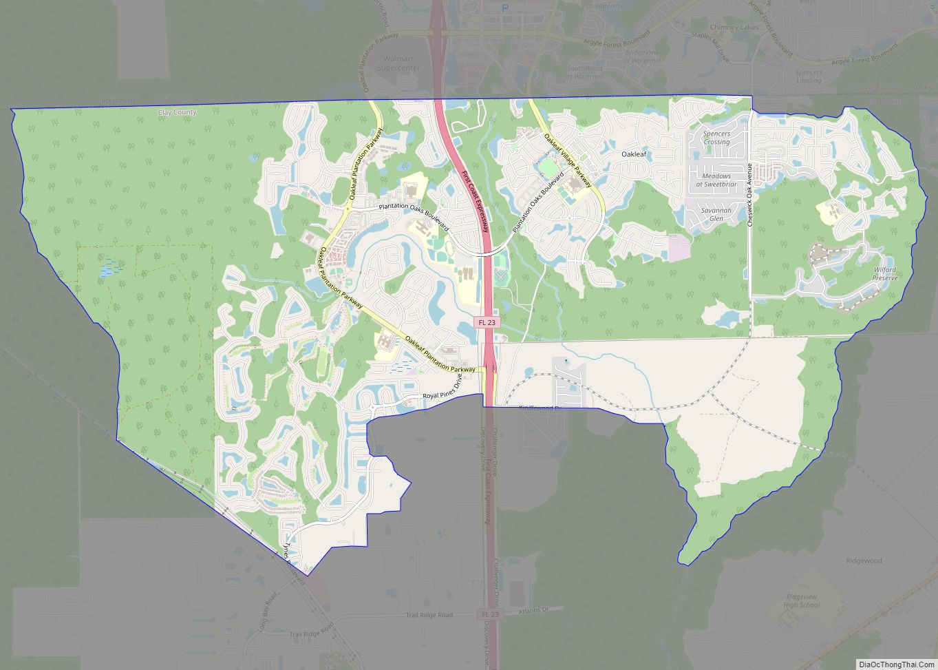
Coordinates: 30°10′N 81°50′W / 30.167°N 81.833°W / 30.167; -81.833 Oakleaf Plantation is a planned community in the Jacksonville area located mostly in unincorporated Clay County and partially within the Jacksonville city limits (Duval County). The Clay County portion is a census-designated place, with a 2010 population of 20,315. As of 2020, the population has risen ... Read more
Map of Oakleaf Plantation CDP
Map of Oakland town, Florida
Oakland is a town in Orange County, Florida, United States. The population was 3,516 at the 2020 Census, representing a growth of 38.5% over the population of 2,538 recorded during the 2010 census. It is part of the Orlando–Kissimmee Metropolitan Statistical Area. Oakland town overview: Name: Oakland town LSAD Code: 43 LSAD Description: town (suffix) ... Read more
Map of Oakland town, Florida
Map of Ocean Ridge town
Ocean Ridge is a town in Palm Beach County, Florida, United States. The population was 1,786 at the 2010 census. As of 2018, the population recorded by the U.S. Census Bureau is 1,956. It is part of the Miami Metropolitan Area. Ocean Ridge town overview: Name: Ocean Ridge town LSAD Code: 43 LSAD Description: town ... Read more
Map of Ocean Ridge town
Map of Ocean City CDP, Florida
Ocean City is a census-designated place (CDP) in Okaloosa County, Florida, United States. The population was 5,594 at the 2000 census. It is part of the Fort Walton Beach–Crestview–Destin Metropolitan Statistical Area. Ocean City CDP overview: Name: Ocean City CDP LSAD Code: 57 LSAD Description: CDP (suffix) State: Florida County: Okaloosa County Elevation: 10 ft (3 m) ... Read more
Map of Ocean City CDP, Florida
Map of Ocean Breeze town
Ocean Breeze, formerly Ocean Breeze Park, is a town on the Indian River in Martin County, Florida, United States. Ocean Breeze and Briny Breezes in Palm Beach County are the only two towns in Florida in which all residents live in a mobile home park bearing the name of the town. The population was 301 ... Read more
Map of Ocean Breeze town
Map of Ojus CDP
Ojus is a census-designated place and formerly incorporated town in Miami-Dade County, Florida, United States. The population was 19,673 at the 2020 census, up from 18,036 in 2010. Ojus CDP overview: Name: Ojus CDP LSAD Code: 57 LSAD Description: CDP (suffix) State: Florida County: Miami-Dade County Elevation: 10 ft (3 m) Total Area: 3.16 sq mi (8.18 km²) Land Area: ... Read more
Map of Ojus CDP
Map of Odessa CDP, Florida
Odessa is a census-designated place (CDP) in Pasco County, Florida, United States. The population was 3,173 at the 2000 census and more than doubled to 7,267 in 2010. Northwest of Tampa, Odessa had been an area of open spaces, ranching, and horse properties. More recently it has seen many suburban property developments as Tampa’s population ... Read more
Map of Odessa CDP, Florida
Map of Ocoee city
Ocoee (/əˈkoʊ.i/) is a city in Orange County, Florida, United States. According to the 2019 US Census population estimate, the city had a population of 48,263. It is part of the Orlando–Kissimmee–Sanford, Florida Metropolitan Statistical Area. Ocoee city overview: Name: Ocoee city LSAD Code: 25 LSAD Description: city (suffix) State: Florida County: Orange County Elevation: ... Read more
Map of Ocoee city
Map of Oldsmar city
Oldsmar is a city in Pinellas County, Florida, United States. As of the 2020 census, the city had a population of 14,898. The Oldsmar name dates to April 12, 1916 when automobile pioneer Ransom E. Olds purchased 37,541 acres (151.92 km) of land north of Tampa Bay to establish a planned community. Oldsmar city overview: Name: ... Read more
Map of Oldsmar city
Map of Okeechobee city
Okeechobee (US: /oʊkiˈtʃoʊbi/ OH-kee-CHOH-bee) is a city in and the county seat of Okeechobee County, Florida, United States. As of the 2020 United States Census, the city’s population was 5,254. The Lake Okeechobee area was severely damaged in the 1928 Okeechobee Hurricane, the first recorded Category 5 hurricane in the North Atlantic. This was one ... Read more
Map of Okeechobee city
Map of Okahumpka CDP
Okahumpka is an unincorporated community and census-designated place (CDP) in Lake County, Florida, United States. The population was 267 at the 2010 census. It is part of the Orlando–Kissimmee Metropolitan Statistical Area. It is the location of the Historic Campbell House, listed on the National Register of Historic Places. Okahumpka CDP overview: Name: Okahumpka CDP ... Read more
Map of Okahumpka CDP
Map of Ona CDP
Ona is an unincorporated community and census-designated place in Hardee County, Florida, United States. Its population was 199 as of the 2020 census. Ona has a post office with ZIP code 33865, which opened on October 11, 1897. State Road 64 and a CSX Transportation line pass through the community. Ona CDP overview: Name: Ona ... Read more
Map of Ona CDP