Map of Roseland CDP, Florida
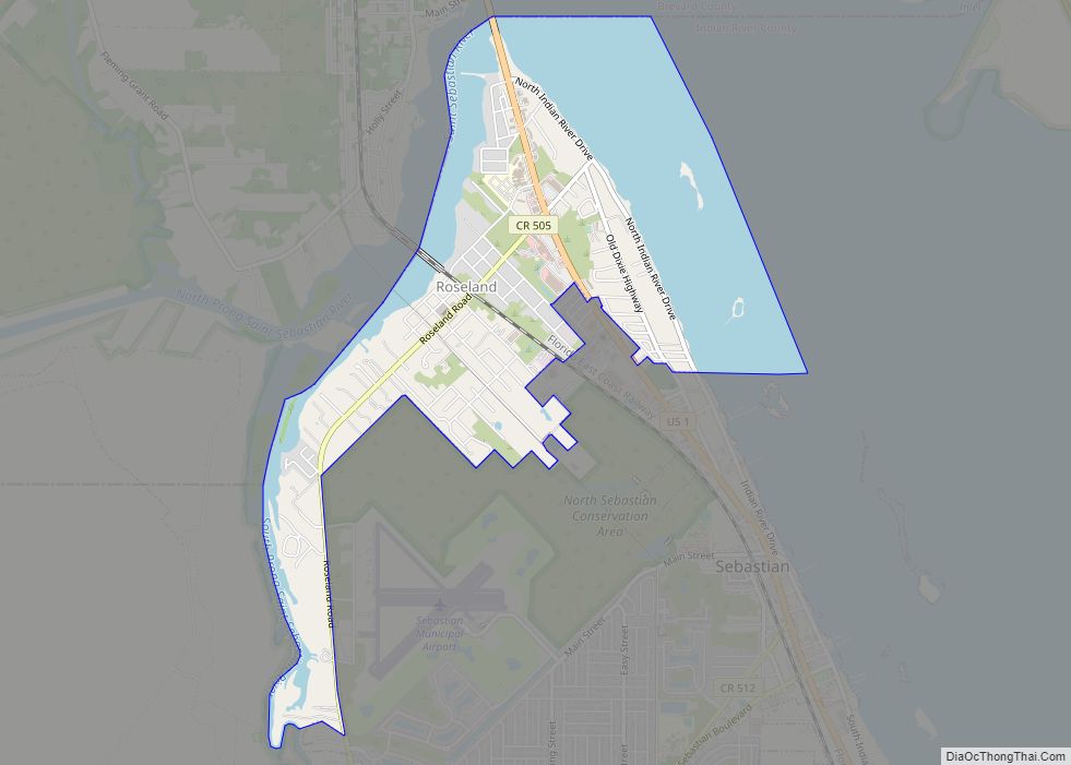
Roseland is an unincorporated community and census-designated place (CDP) in Indian River County, Florida, United States. The population was 1,472 at the 2010 census, down from 1,775 at the 2000 census. It is part of the Sebastian–Vero Beach Metropolitan Statistical Area. Roseland CDP overview: Name: Roseland CDP LSAD Code: 57 LSAD Description: CDP (suffix) State: ... Read more
Map of Roseland CDP, Florida
Map of Roosevelt Gardens CDP
Roosevelt Gardens is a census-designated place (CDP) in Broward County, Florida, United States. The population was 2,456 at the 2010 census. Roosevelt Gardens CDP overview: Name: Roosevelt Gardens CDP LSAD Code: 57 LSAD Description: CDP (suffix) State: Florida County: Broward County Total Area: 0.32 sq mi (0.83 km²) Land Area: 0.32 sq mi (0.83 km²) Water Area: 0.00 sq mi (0.00 km²) Total Population: ... Read more
Map of Roosevelt Gardens CDP
Map of Ruskin CDP, Florida
Ruskin is an unincorporated census-designated place in Hillsborough County, Florida. The area was part of the chiefdom of the Uzita at the time of the Hernando de Soto expedition in 1539. The community was founded August 7, 1908, on the shores of the Little Manatee River. It was developed by Dr. George McAnelly Miller, an ... Read more
Map of Ruskin CDP, Florida
Map of Royal Palm Estates CDP
Royal Palm Estates is a census-designated place (CDP) in Palm Beach County, Florida, United States. The population was 1,974 at the 2020 census. Royal Palm Estates CDP overview: Name: Royal Palm Estates CDP LSAD Code: 57 LSAD Description: CDP (suffix) State: Florida County: Palm Beach County Elevation: 16 ft (5 m) Total Area: 0.25 sq mi (0.65 km²) Land Area: ... Read more
Map of Royal Palm Estates CDP
Map of Royal Palm Beach village
Royal Palm Beach is a village in southeast Florida, located within Palm Beach County. The population was measured at 34,140 in the 2010 census. It is part of the Miami Metropolitan Area. Despite its name, the village is located approximately fifteen miles inland from the Atlantic Ocean. Royal Palm Beach is known for its many ... Read more
Map of Royal Palm Beach village
Map of Samsula-Spruce Creek CDP
Samsula-Spruce Creek is a census-designated place (CDP) in Volusia County, Florida, United States. The population was 5,047 at the 2010 census. While many households reside here, it is principally an agricultural area west of the cities of Port Orange and New Smyrna Beach. Samsula-Spruce Creek CDP overview: Name: Samsula-Spruce Creek CDP LSAD Code: 57 LSAD ... Read more
Map of Samsula-Spruce Creek CDP
Map of Samoset CDP
Samoset is an unincorporated community and census-designated place (CDP) in Manatee County, Florida, United States. The population was 4,146 at the 2020 census, up from 3,854 in 2010. It is part of the Bradenton–Sarasota–Venice Metropolitan Statistical Area. Samoset CDP overview: Name: Samoset CDP LSAD Code: 57 LSAD Description: CDP (suffix) State: Florida County: Manatee County ... Read more
Map of Samoset CDP
Map of Safety Harbor city
Safety Harbor is a city on the west shore of Tampa Bay in Pinellas County, Florida, United States. It was settled in 1823 and incorporated in 1917. The population was 16,884 at the 2010 census. Safety Harbor city overview: Name: Safety Harbor city LSAD Code: 25 LSAD Description: city (suffix) State: Florida County: Pinellas County ... Read more
Map of Safety Harbor city
Map of San Castle CDP
San Castle is an unincorporated community and census-designated place in Palm Beach County, Florida, United States. Its population was 3,755 as of the 2020 census. San Castle is located between Interstate 95 and the Intracoastal Waterway; it borders Lantana to the south, Hypoluxo to the west and Boynton Beach to the northeast. San Castle CDP ... Read more
Map of San Castle CDP
Map of San Carlos Park CDP
San Carlos Park is a census-designated place (CDP) in Lee County, Florida, United States. The population was 18,563 at the 2020 census. It is part of the Cape Coral-Fort Myers, Florida Metropolitan Statistical Area. San Carlos Park CDP overview: Name: San Carlos Park CDP LSAD Code: 57 LSAD Description: CDP (suffix) State: Florida County: Lee ... Read more
Map of San Carlos Park CDP
Map of San Antonio city, Florida
San Antonio, or unofficially San Ann as the locals call it, is a city in Pasco County, Florida, United States. It is a suburban city included in the Tampa-St. Petersburg-Clearwater, Florida Metropolitan Statistical Area. It lies within Florida’s 12th congressional district. The population was 1,138 at the 2010 census. It was established as a Catholic ... Read more
Map of San Antonio city, Florida
Map of Sanford city, Florida
Sanford is a city in the U.S. state of Florida and the county seat of Seminole County. It is located in Central Florida and its population was 61,051 as of the 2020 census. Known as the “Historic Waterfront Gateway City”, Sanford sits on the southern shore of Lake Monroe at the head of navigation on ... Read more
Map of Sanford city, Florida