Map of Seville CDP, Florida
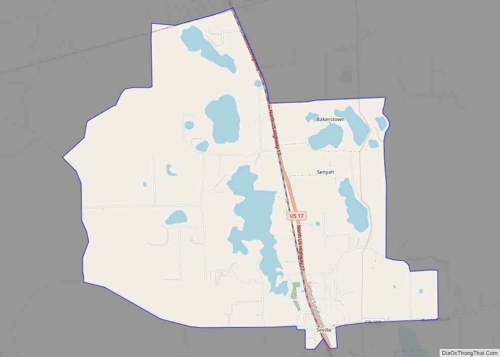
Seville is an unincorporated community and census-designated place in Volusia County, Florida, United States, founded in 1882. As of the 2010 census it had a population of 614. Seville CDP overview: Name: Seville CDP LSAD Code: 57 LSAD Description: CDP (suffix) State: Florida County: Volusia County ZIP code: 32190 Area code: 386 FIPS code: 1265200 ... Read more
Map of Seville CDP, Florida
Map of Seminole city, Florida
Seminole is a city in Pinellas County, Florida, United States. The population was 19,364 at the 2020 census. Seminole city overview: Name: Seminole city LSAD Code: 25 LSAD Description: city (suffix) State: Florida County: Pinellas County Elevation: 36 ft (11 m) Total Area: 5.68 sq mi (14.71 km²) Land Area: 5.18 sq mi (13.42 km²) Water Area: 0.50 sq mi (1.29 km²) Total Population: 19,364 Population ... Read more
Map of Seminole city, Florida
Map of Sharpes CDP
Sharpes is a census-designated place (CDP) in Brevard County, Florida. The population was 3,411 at the 2010 United States Census. It is part of the Palm Bay–Melbourne–Titusville Metropolitan Statistical Area. Sharpes CDP overview: Name: Sharpes CDP LSAD Code: 57 LSAD Description: CDP (suffix) State: Florida County: Brevard County Elevation: 20 ft (6 m) Total Area: 5.86 sq mi (15.17 km²) ... Read more
Map of Sharpes CDP
Map of Shalimar town
Shalimar is a town in Okaloosa County, Florida, United States. The population was 717 at the 2010 census. It is part of the Fort Walton Beach–Crestview–Destin Metropolitan Statistical Area. Shalimar town overview: Name: Shalimar town LSAD Code: 43 LSAD Description: town (suffix) State: Florida County: Okaloosa County Elevation: 13 ft (4 m) Total Area: 0.29 sq mi (0.75 km²) Land ... Read more
Map of Shalimar town
Map of Shady Hills CDP
Shady Hills is a census-designated place (CDP) in Pasco County, Florida, United States. The population was 7,798 at the 2000 census. It is in the Tampa-St. Petersburg-Clearwater, Florida Metropolitan Statistical Area. It is home to an active pigeon racing group. Shady Hills CDP overview: Name: Shady Hills CDP LSAD Code: 57 LSAD Description: CDP (suffix) ... Read more
Map of Shady Hills CDP
Map of Silver Springs Shores CDP
Silver Springs Shores is a census-designated place (CDP) in Marion County, Florida, United States. The population was 24,846 at the 2020 census. It is part of the Ocala Metropolitan Statistical Area. The community, often referred to by locals as simply “the shores”, serves primarily as a bedroom community for Ocala. It is the largest community ... Read more
Map of Silver Springs Shores CDP
Map of Silver Lake CDP, Florida
Silver Lake is a census-designated place (CDP) in Lake County, Florida, United States. The population was 1,879 at the 2010 census. It is part of the Orlando–Kissimmee Metropolitan Statistical Area. Silver Lake CDP overview: Name: Silver Lake CDP LSAD Code: 57 LSAD Description: CDP (suffix) State: Florida County: Lake County Elevation: 66 ft (20 m) Total Area: ... Read more
Map of Silver Lake CDP, Florida
Map of Siesta Key CDP
Siesta Key is a barrier island off the southwest coast of the U.S. state of Florida, located between Roberts Bay and the Gulf of Mexico. A portion of it lies within the city boundary of Sarasota, but the majority of the key is a census-designated place (CDP) in Sarasota County. Siesta Key is part of ... Read more
Map of Siesta Key CDP
Map of Sneads town
Sneads is a town in Jackson County, Florida, United States. The population was 1,849 at the 2010 census. Sneads is governed by a five-member town council and a city manager. It also has an all-volunteer fire rescue department, and its own police force of eight sworn officers: six full-time officers, an Administrative Assistant, and three ... Read more
Map of Sneads town
Map of Sky Lake CDP
Sky Lake is a census-designated place (CDP) and an unincorporated area in Orange County, Florida, United States. The population was 6,153 at the 2010 census. It is part of the Orlando-Kissimmee, Florida Metropolitan Statistical Area. Sky Lake CDP overview: Name: Sky Lake CDP LSAD Code: 57 LSAD Description: CDP (suffix) State: Florida County: Orange County ... Read more
Map of Sky Lake CDP
Map of Solana CDP
Solana is an unincorporated community and census-designated place (CDP) in Charlotte County, Florida, United States. The population was 671 at the 2020 census. It is part of the Sarasota-Bradenton-Punta Gorda Combined Statistical Area. Solana CDP overview: Name: Solana CDP LSAD Code: 57 LSAD Description: CDP (suffix) State: Florida County: Charlotte County Elevation: 0 ft (0 m) Total ... Read more
Map of Solana CDP
Map of South Apopka CDP
South Apopka is a census-designated place and an unincorporated area in Orange County, Florida, United States. Per the 2020 census, the population was 6,803. It is part of the Orlando–Kissimmee Metropolitan Statistical Area. South Apopka CDP overview: Name: South Apopka CDP LSAD Code: 57 LSAD Description: CDP (suffix) State: Florida County: Orange County Elevation: 125 ft ... Read more
Map of South Apopka CDP