Map of Vineyards CDP
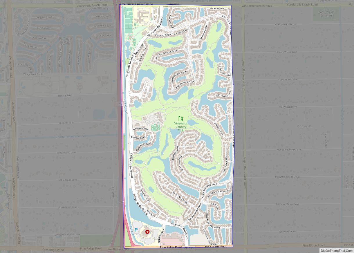
Vineyards is a census-designated place (CDP) in Collier County, Florida, United States. The population was 3,883 at the 2020 census. It is part of the Naples–Marco Island Metropolitan Statistical Area. Vineyards CDP overview: Name: Vineyards CDP LSAD Code: 57 LSAD Description: CDP (suffix) State: Florida County: Collier County Elevation: 10 ft (3 m) Total Area: 2.26 sq mi (5.86 km²) ... Read more
Map of Vineyards CDP
Map of Villas CDP, Florida
Villas, Florida is an unincorporated community and census-designated place (CDP) in Lee County, Florida, United States. It is part of the Cape Coral-Fort Myers, Florida Metropolitan Statistical Area. Villas CDP overview: Name: Villas CDP LSAD Code: 57 LSAD Description: CDP (suffix) State: Florida County: Lee County Elevation: 10 ft (3 m) Total Area: 4.85 sq mi (12.56 km²) Land Area: ... Read more
Map of Villas CDP, Florida
Map of Wabasso CDP, Florida
Wabasso is an unincorporated community and census-designated place (CDP) in Indian River County, Florida, United States. The population was 609 at the 2010 census, down from 918 at the 2000 census. It is located at the intersection of U.S. 1 and SR 510. Wabasso is part of the Sebastian–Vero Beach Metropolitan Statistical Area. Wabasso CDP ... Read more
Map of Wabasso CDP, Florida
Map of Wabasso Beach CDP
Wabasso Beach is a census-designated place (CDP) in Indian River County, Florida, United States. The population was 1,853 at the 2010 census, an increase of 72.4% since 2000. It is part of the Sebastian–Vero Beach Metropolitan Statistical Area. Wabasso Beach CDP overview: Name: Wabasso Beach CDP LSAD Code: 57 LSAD Description: CDP (suffix) State: Florida ... Read more
Map of Wabasso Beach CDP
Map of Virginia Gardens village
Virginia Gardens is a village in Miami-Dade County, Florida, United States. According to the U.S. Census Bureau, the village had a population of 2,364 in 2020. Virginia Gardens village overview: Name: Virginia Gardens village LSAD Code: 47 LSAD Description: village (suffix) State: Florida County: Miami-Dade County Incorporated: July 10, 1947 Elevation: 3 ft (1 m) Total Area: ... Read more
Map of Virginia Gardens village
Map of Waldo city, Florida
Waldo is a city in Alachua County, Florida, United States. According to the 2010 census the population was 1,015, up from 821 in 2000. Waldo city overview: Name: Waldo city LSAD Code: 25 LSAD Description: city (suffix) State: Florida County: Alachua County Elevation: 167 ft (51 m) Total Area: 2.33 sq mi (6.03 km²) Land Area: 2.17 sq mi (5.63 km²) Water Area: ... Read more
Map of Waldo city, Florida
Map of Wahneta CDP
Wahneta is a census-designated place (CDP) in central Polk County, Florida, United States. The population was 4,731 at the 2000 census. It is part of the Lakeland–Winter Haven Metropolitan Statistical Area. Wahneta CDP overview: Name: Wahneta CDP LSAD Code: 57 LSAD Description: CDP (suffix) State: Florida County: Polk County Elevation: 135 ft (41 m) Total Area: 2.27 sq mi ... Read more
Map of Wahneta CDP
Map of Wacissa CDP
Wacissa is a small unincorporated community and census-designated place (CDP) in Jefferson County, Florida, United States. As of the 2020 census, the population was 362. It shares its name with the Wacissa River, the headwaters of which are about one mile to the south. Wacissa CDP overview: Name: Wacissa CDP LSAD Code: 57 LSAD Description: ... Read more
Map of Wacissa CDP
Map of Warrington CDP
Warrington is a census-designated place (CDP) in Escambia County, Florida, United States. Warrington is located between downtown Pensacola and the state line with Alabama; it is 6 miles (10 km) away from both. The population was 14,531 at the 2010 census. It is part of the Pensacola–Ferry Pass–Brent Metropolitan Statistical Area. A failed referendum was held ... Read more
Map of Warrington CDP
Map of Warm Mineral Springs CDP
Warm Mineral Springs is a census-designated place (CDP) in Sarasota County, Florida, United States. The population was 5,061 at the 2010 census. It is part of the Bradenton–Sarasota–Venice Metropolitan Statistical Area. The Warm Mineral Springs locale is notable for a free-flowing artesian spring. A large portion of the area was annexed by the municipality of ... Read more
Map of Warm Mineral Springs CDP
Map of Wallace CDP, Florida
Wallace is an unincorporated community and census-designated place in Santa Rosa County, Florida, United States. Its population was 1,785 as of the 2010 census. Wallace CDP overview: Name: Wallace CDP LSAD Code: 57 LSAD Description: CDP (suffix) State: Florida County: Santa Rosa County Elevation: 180 ft (50 m) Total Area: 11.751 sq mi (30.43 km²) Land Area: 11.716 sq mi (30.34 km²) Water ... Read more
Map of Wallace CDP, Florida
Map of Watertown CDP, Florida
Watertown is a census-designated place (CDP) in Columbia County, Florida, United States. As of the 2010 census, it had a population of 2,829. Watertown CDP overview: Name: Watertown CDP LSAD Code: 57 LSAD Description: CDP (suffix) State: Florida County: Columbia County Elevation: 184 ft (56 m) Total Area: 2.53 sq mi (6.55 km²) Land Area: 2.48 sq mi (6.42 km²) Water Area: 0.05 sq mi ... Read more
Map of Watertown CDP, Florida