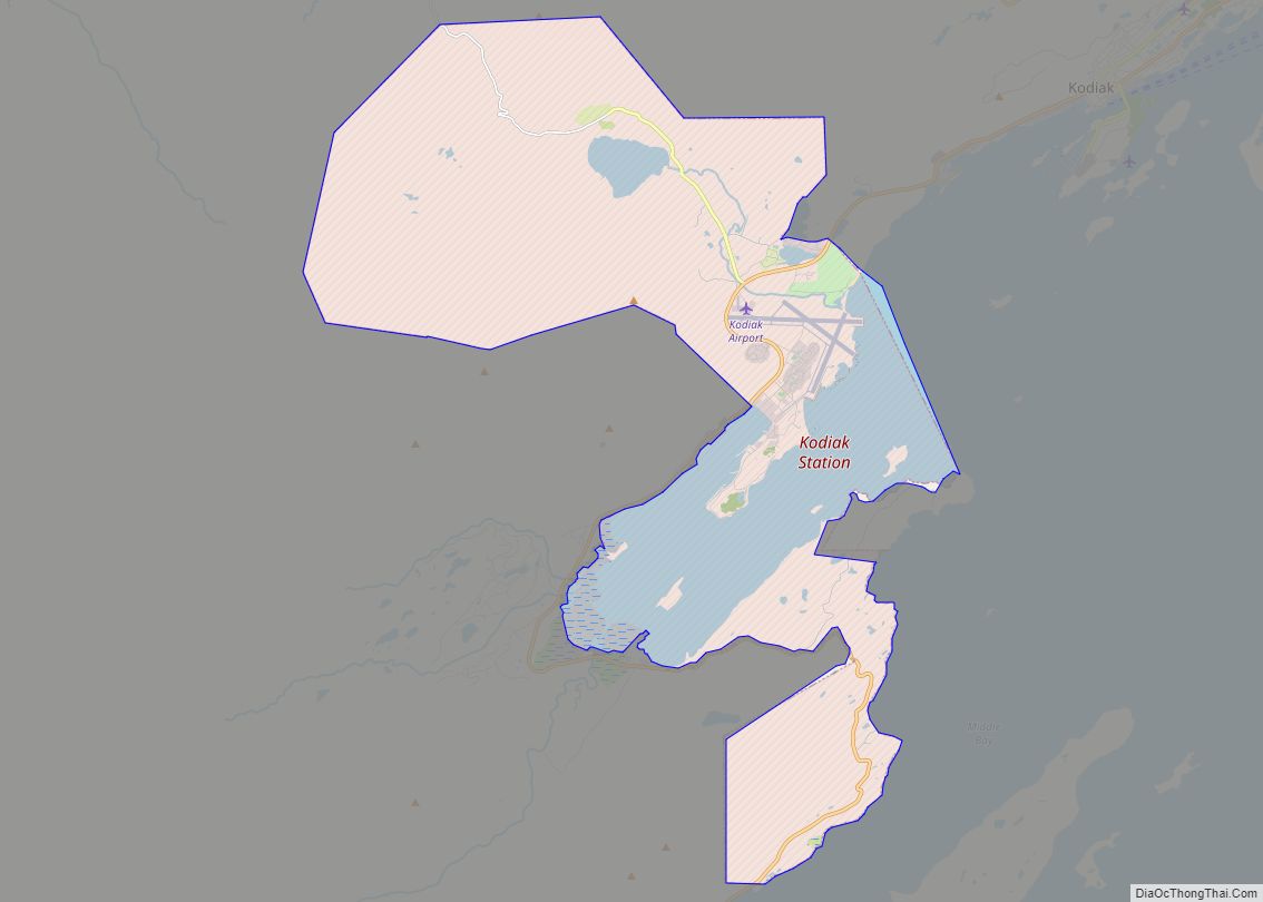
Map of Kobuk city

Map of Kobuk city

Kobuk (Inupiaq: Laugviik) is a city in Northwest Arctic Borough, Alaska, United States. At the 2010 census the population was 151, up from 109 in 2000. Kobuk city overview: Name: Kobuk city LSAD Code: 25 LSAD Description: city (suffix) State: Alaska County: Northwest Arctic Borough Incorporated: September 25, 1973 Elevation: 148 ft (45 m) Total Area: 16.02 sq mi … Read more

Map of Knik River CDP

Map of Knik River CDP

Knik River /ˈknɪk/ is a census-designated place (CDP) in Matanuska-Susitna Borough in the U.S. state of Alaska. Located 15 miles southeast from Palmer along the Knik River, it is part of the Anchorage, Alaska Metropolitan Statistical Area. The population was 792 at the 2020 census, up from 744 in 2010. Knik River CDP overview: Name: … Read more

Map of Kokhanok CDP

Map of Kokhanok CDP

Kokhanok (Central Yupik: Qarr’unaq) is a census-designated place (CDP) in Lake and Peninsula Borough, Alaska, United States. At the 2020 census the population was 152, down from 170 in 2000. Kokhanok CDP overview: Name: Kokhanok CDP LSAD Code: 57 LSAD Description: CDP (suffix) State: Alaska County: Lake and Peninsula Borough Elevation: 100 ft (30 m) Total Area: … Read more

Map of Kodiak city

Map of Kodiak city

Kodiak (Alutiiq: Sun’aq), formerly Paul’s Harbor, is the main city and one of seven communities on Kodiak Island in Kodiak Island Borough, Alaska. All commercial transportation between the island’s communities and the outside world goes through this city via ferryboat or airline. As of the 2020 census, the population of the city is 5,581, down … Read more

Map of Koliganek CDP

Map of Koliganek CDP

Koliganek (Central Yupik: Qalirneq) is a census-designated place (CDP) in Dillingham Census Area, Alaska, United States. It is located along the Nushagak River At the 2010 census, the population was 209, up from 182 in 2000. Koliganek CDP overview: Name: Koliganek CDP LSAD Code: 57 LSAD Description: CDP (suffix) State: Alaska County: Dillingham Census Area … Read more

Map of Kotzebue city

Map of Kotzebue city

Kotzebue (/ˈkɒtsəbjuː/ KOTS-ə-bew) or Qikiqtaġruk (/kɪkɪkˈtʌɡrʊk/ kik-ik-TUG-rook, Inupiaq: [qekeqtɑʁʐuk]) is a city in the Northwest Arctic Borough in the U.S. state of Alaska. It is the borough’s seat, by far its largest community and the economic and transportation hub of the subregion of Alaska encompassing the borough. The population of the city was 3,102 as of … Read more

Map of Kotlik city

Map of Kotlik city

Kotlik (Central Yupik: Qerrulliik, Russian: Котлик) is a city in Kusilvak Census Area, Alaska, United States. At the 2010 census the population was 577, down from 591 in 2000. Kotlik city overview: Name: Kotlik city LSAD Code: 25 LSAD Description: city (suffix) State: Alaska County: Kusilvak Census Area Incorporated: October 28, 1970 Elevation: 0 ft (0 m) … Read more

Map of Kongiganak CDP

Map of Kongiganak CDP

Kongiganak (Central Yupik: Kangirnaq) is a census-designated place (CDP) in Bethel Census Area, Alaska, United States, and primarily sits on the eastern shore of the Kongiganak River. As of the 2010 census, the population was 439, up from 359 in 2000. Kongiganak CDP overview: Name: Kongiganak CDP LSAD Code: 57 LSAD Description: CDP (suffix) State: … Read more

Map of Kupreanof city

Map of Kupreanof city

Kupreanof (Lingít: Aansadaak’w) is a city at the eastern shore of Kupreanof Island in the Petersburg Borough, in the U.S. state of Alaska. The population was 21 as of the 2020 census, down from 27 in 2010. It is the smallest incorporated city in the state as of 2020. Kupreanof city overview: Name: Kupreanof city … Read more

Map of Koyukuk city

Map of Koyukuk city

Koyukuk (/ˈkaɪjəkək/) (Koyukon: Meneelghaadze’ T’oh [məniːlʁæːt͡səʔ tʼoh]) is a city in Yukon-Koyukuk Census Area, Alaska, United States. At the 2010 census the population was 96, down from 101 in 2000. As of 2009, Koyukuk is one of a number of Alaskan communities threatened by erosion. Koyukuk city overview: Name: Koyukuk city LSAD Code: 25 LSAD … Read more

Map of Koyuk city

Map of Koyuk city

Koyuk (Inupiaq: Kuuyuk) is a city in the Nome Census Area, Alaska, United States. The population was 332 at the 2010 census, up from 297 in 2000. Koyuk city overview: Name: Koyuk city LSAD Code: 25 LSAD Description: city (suffix) State: Alaska County: Nome Census Area Incorporated: October 19, 1970 Elevation: 33 ft (10 m) Total Area: … Read more

Map of Lake Louise CDP

Map of Lake Louise CDP

Lake Louise (Sasnuu’ Bene’ in Ahtna) is a census-designated place (CDP) in Matanuska-Susitna Borough, Alaska, United States. Although it is an isolated settlement and is close to Glennallen, it is considered part of the Anchorage Metropolitan Area, like all other locations in the Mat-Su Borough. At the 2020 census the population was 15, down from … Read more