Map of Kwigillingok CDP

Map of Kwigillingok CDP

Kwigillingok (Central Yupik: Kuigilnguq) is a census-designated place (CDP) in Bethel Census Area, Alaska, United States. The population was 321 at the 2010 census, down from 338 in 2000. Kwigillingok CDP overview: Name: Kwigillingok CDP LSAD Code: 57 LSAD Description: CDP (suffix) State: Alaska County: Bethel Census Area Total Area: 23.83 sq mi (61.71 km²) Land Area: 23.79 sq mi … Read more

Map of Kwethluk city

Map of Kwethluk city

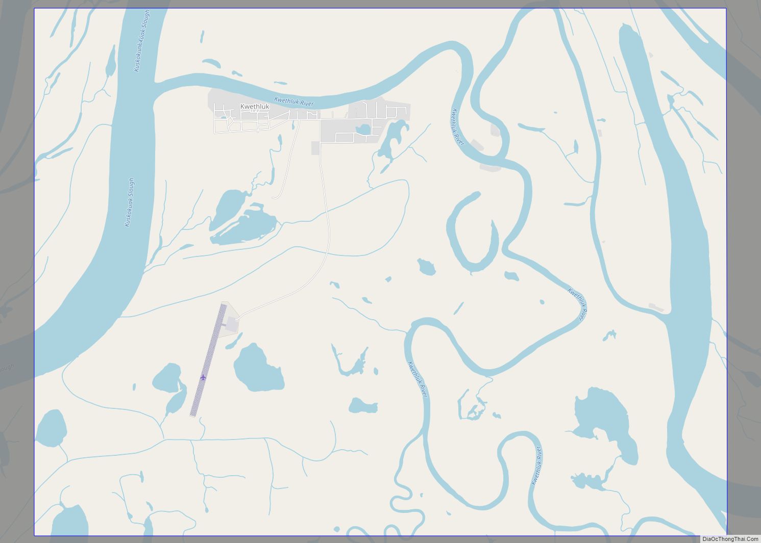
Kwethluk (/ˈkwiːθlʊk/ KWEETH-luuk; Central Yupik: Kuiggluk) is a city in Bethel Census Area in the U.S. state of Alaska. At the 2010 census the population was 721, up from 713 in 2000. Kwethluk city overview: Name: Kwethluk city LSAD Code: 25 LSAD Description: city (suffix) State: Alaska County: Bethel Census Area Incorporated: 1975 Elevation: 10 ft … Read more

Map of Larsen Bay city

Map of Larsen Bay city

Larsen Bay (Alutiiq: Uyaqsaq) is a city in Kodiak Island Borough, Alaska, United States. At the 2010 census the population was 87, down from 115 in 2000. Larsen Bay city overview: Name: Larsen Bay city LSAD Code: 25 LSAD Description: city (suffix) State: Alaska County: Kodiak Island Borough Incorporated: 1974 Elevation: 3 ft (1 m) Total Area: … Read more

Map of Lakes CDP

Map of Lakes CDP

Lakes CDP overview: Name: Lakes CDP LSAD Code: 57 LSAD Description: CDP (suffix) State: Alaska County: Matanuska-Susitna Borough FIPS code: 0242832 Online Interactive Map Lakes online map. Source: Basemap layers from Google Map, Open Street Map (OSM), Arcgisonline, Wmflabs. Boundary Data from Database of Global Administrative Areas. Lakes location map. Where is Lakes CDP? Lakes … Read more

Map of Lake Minchumina CDP

Map of Lake Minchumina CDP

Lake Minchumina (Menchuh Mene’ [mənt͡ʃʰuh mənə] in Koyukon; Minchu Mina’ in Dinak’i) is a census-designated place (CDP) in Yukon-Koyukuk Census Area, Alaska, United States. As of the 2020 census, the population of the CDP is 30. Lake Minchumina CDP overview: Name: Lake Minchumina CDP LSAD Code: 57 LSAD Description: CDP (suffix) State: Alaska County: Yukon-Koyukuk … Read more

Map of Lime Village CDP

Map of Lime Village CDP

Lime Village (Hekdichen Hdakaq’ in Dena’ina) is a census-designated place (CDP) in Bethel Census Area, Alaska, United States. The 2010 census found a population of 29, down from 46 in 2000. It has also been known as Hungry Village. In July 2008, Lime Village gained notoriety when it was reported that their gasoline prices were … Read more

Map of Levelock CDP

Map of Levelock CDP

Levelock (Central Yupik: Liivlek) is a census-designated place (CDP) along the Kvichak River in Lake and Peninsula Borough, Alaska, United States. It was known by the indigenous name of Kivichakh, a variant of Kvichak. At the 2020 census the population was 69, same amount as in 2010. Levelock CDP overview: Name: Levelock CDP LSAD Code: … Read more

Map of Lazy Mountain CDP

Map of Lazy Mountain CDP

Lazy Mountain is a census-designated place (CDP) in Matanuska-Susitna Borough, Alaska, United States. Located east of Palmer along the Matanuska River. At the 2020 census the population was 1,506, up from 1,479 in 2010. Lazy Mountain CDP overview: Name: Lazy Mountain CDP LSAD Code: 57 LSAD Description: CDP (suffix) State: Alaska County: Matanuska-Susitna Borough Elevation: … Read more

Map of Lowell Point CDP

Map of Lowell Point CDP

Lowell Point is a census-designated place (CDP) in Kenai Peninsula Borough, Alaska, United States, just outside Seward. At the 2010 census the population was 80, down from 92 in 2000. Lowell Point CDP overview: Name: Lowell Point CDP LSAD Code: 57 LSAD Description: CDP (suffix) State: Alaska County: Kenai Peninsula Borough Elevation: 36 ft (11 m) Total … Read more

Map of Loring CDP

Map of Loring CDP

Loring (Lingít: Kax̱.àan) was established in 1885 with the first post office in the District of Alaska and is a census-designated place (CDP) in Ketchikan Gateway Borough in the U.S. state of Alaska. The population was 4 at the 2010 census, although the number increases in summer months. Located due north of downtown Ketchikan on … Read more

Map of Livengood CDP

Map of Livengood CDP

Livengood /ˈlaɪvənɡʊd/ is a census-designated place (CDP) in Yukon-Koyukuk Census Area, Alaska, United States. The population was 13 at the 2010 census, down from 29 in 2000. Livengood CDP overview: Name: Livengood CDP LSAD Code: 57 LSAD Description: CDP (suffix) State: Alaska County: Yukon-Koyukuk Census Area Elevation: 696 ft (212 m) Total Area: 265.64 sq mi (688.01 km²) Land Area: … Read more

Map of Lutak CDP

Map of Lutak CDP

Lutak (Lingít: Lḵoot) is a census-designated place (CDP) in Haines Borough, Alaska, United States. The population was 49 at the 2010 census, up from 39 in 2000. Lutak CDP overview: Name: Lutak CDP LSAD Code: 57 LSAD Description: CDP (suffix) State: Alaska County: Haines Borough Elevation: 30 ft (9 m) Total Area: 133.26 sq mi (345.14 km²) Land Area: 126.96 sq mi … Read more