Map of Montezuma town, Indiana
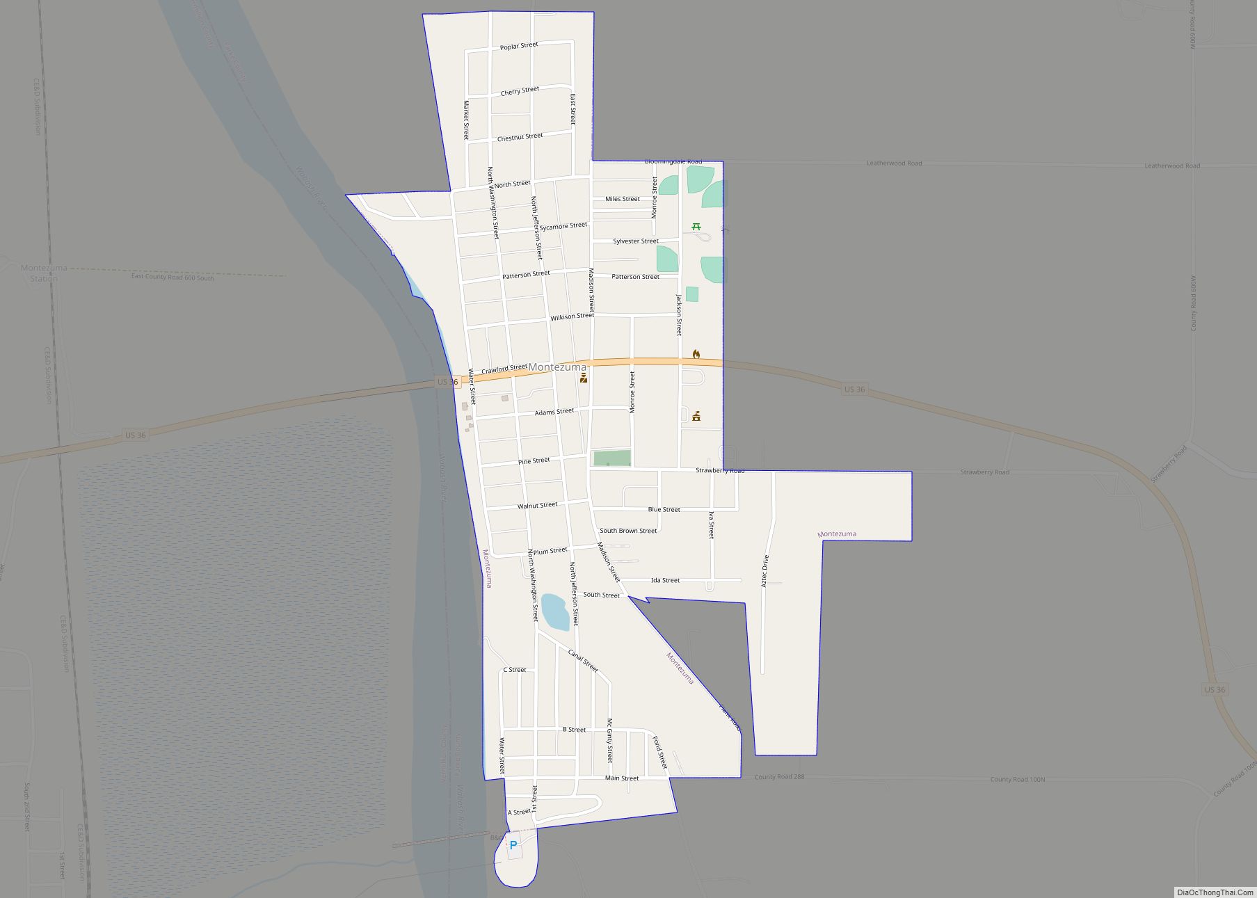
Montezuma is a town in Reserve Township, Parke County, in the U.S. state of Indiana. The population was 1,022 at the 2010 census. It is located approximately 66 miles west of the state capital Indianapolis. Montezuma town overview: Name: Montezuma town LSAD Code: 43 LSAD Description: town (suffix) State: Indiana County: Parke County Elevation: 505 ft ... Read more
Map of Montezuma town, Indiana
Map of Monterey town, Indiana
Monterey is a town in Tippecanoe Township, Pulaski County, in the U.S. state of Indiana. The population was 218 at the 2010 census. Monterey town overview: Name: Monterey town LSAD Code: 43 LSAD Description: town (suffix) State: Indiana County: Pulaski County Elevation: 725 ft (221 m) Total Area: 0.18 sq mi (0.47 km²) Land Area: 0.18 sq mi (0.47 km²) Water Area: 0.00 sq mi ... Read more
Map of Monterey town, Indiana
Map of Montmorenci CDP
Montmorenci is an unincorporated census-designated place in Shelby Township, Tippecanoe County, Indiana. Older maps sometimes spell the name Montmorency or Montmorencie. It is part of the Lafayette, Indiana Metropolitan Statistical Area. Montmorenci CDP overview: Name: Montmorenci CDP LSAD Code: 57 LSAD Description: CDP (suffix) State: Indiana County: Tippecanoe County Elevation: 699 ft (213 m) Total Area: 1.59 sq mi ... Read more
Map of Montmorenci CDP
Map of Monticello city, Indiana
Monticello (/ˌmɒntɪˈsɛloʊ/ (listen) MON-tiss-EL-oh) is a city in Union Township, White County, Indiana, United States. The city is the county seat of White County. The population was 5,508 at the 2020 census. Monticello is known as a tourist destination in north-central Indiana and is home to the Indiana Beach amusement park on Lake Shafer, and ... Read more
Map of Monticello city, Indiana
Map of Montgomery town, Indiana
Montgomery is a town in Barr Township, Daviess County, Indiana, United States. The population was 343 at the 2010 census. Montgomery town overview: Name: Montgomery town LSAD Code: 43 LSAD Description: town (suffix) State: Indiana County: Daviess County Elevation: 525 ft (160 m) Total Area: 1.66 sq mi (4.31 km²) Land Area: 1.62 sq mi (4.19 km²) Water Area: 0.05 sq mi (0.12 km²) Total Population: ... Read more
Map of Montgomery town, Indiana
Map of Moores Hill town
Moores Hill is a town in Sparta Township, Dearborn County, Indiana, United States. The population was 597 at the 2010 census. Moores Hill town overview: Name: Moores Hill town LSAD Code: 43 LSAD Description: town (suffix) State: Indiana County: Dearborn County Elevation: 991 ft (302 m) Total Area: 0.43 sq mi (1.11 km²) Land Area: 0.43 sq mi (1.11 km²) Water Area: 0.00 sq mi ... Read more
Map of Moores Hill town
Map of Mooreland town, Indiana
Mooreland is a town in Blue River Township, Henry County, Indiana, United States. The population was 375 at the 2010 census. Mooreland town overview: Name: Mooreland town LSAD Code: 43 LSAD Description: town (suffix) State: Indiana County: Henry County Elevation: 1,138 ft (347 m) Total Area: 0.14 sq mi (0.37 km²) Land Area: 0.14 sq mi (0.37 km²) Water Area: 0.00 sq mi (0.00 km²) Total ... Read more
Map of Mooreland town, Indiana
Map of Montpelier city, Indiana
Montpelier /mɒntˈpiːliər/ is a city in Harrison Township, Blackford County, in the U.S. state of Indiana. This small rural community, the county’s first to be platted, was established by settlers from Vermont, and is named after Vermont’s capital city of Montpelier. Montpelier was a central participant in the Indiana Gas Boom, as natural gas was ... Read more
Map of Montpelier city, Indiana
Map of Morocco town
Morocco is a town in Beaver Township, Newton County, in the U.S. state of Indiana. The population was 1,129 at the 2010 census. Morocco town overview: Name: Morocco town LSAD Code: 43 LSAD Description: town (suffix) State: Indiana County: Newton County Elevation: 699 ft (213 m) Total Area: 1.07 sq mi (2.76 km²) Land Area: 1.07 sq mi (2.76 km²) Water Area: 0.00 sq mi ... Read more
Map of Morocco town
Map of Morgantown town, Indiana
Morgantown is a town at the intersection of Indiana state routes 135 and 252 in Jackson Township, Morgan County, in the U.S. state of Indiana. The population was 1,014 at the 2020 census. Morgantown town overview: Name: Morgantown town LSAD Code: 43 LSAD Description: town (suffix) State: Indiana County: Morgan County Elevation: 679 ft (207 m) Total ... Read more
Map of Morgantown town, Indiana
Map of Mooresville town, Indiana
Mooresville is a town in Brown Township, Morgan County, in the U.S. state of Indiana. As of the 2020 census, the town population was 9,411. Mooresville town overview: Name: Mooresville town LSAD Code: 43 LSAD Description: town (suffix) State: Indiana County: Morgan County Elevation: 718 ft (219 m) Total Area: 6.76 sq mi (17.52 km²) Land Area: 6.71 sq mi (17.37 km²) Water ... Read more
Map of Mooresville town, Indiana
Map of Mount Ayr town, Indiana
Mount Ayr is a town in Jackson Township, Newton County, in the U.S. state of Indiana. The population was 122 at the 2010 census. Mount Ayr town overview: Name: Mount Ayr town LSAD Code: 43 LSAD Description: town (suffix) State: Indiana County: Newton County Elevation: 709 ft (216 m) Total Area: 0.17 sq mi (0.45 km²) Land Area: 0.17 sq mi (0.45 km²) ... Read more
Map of Mount Ayr town, Indiana