Odon is a town in Madison Township, Daviess County, Indiana, United States. The population was 1,354 at the 2010 census. Odon town overview: Name: Odon town LSAD Code: 43 LSAD Description: town (suffix) State: Indiana County: Daviess County Elevation: 541 ft (165 m) Total Area: 0.94 sq mi (2.43 km²) Land Area: 0.93 sq mi (2.41 km²) Water Area: 0.01 sq mi (0.02 km²) Total Population: ... Read more
Map of US Cities and Places
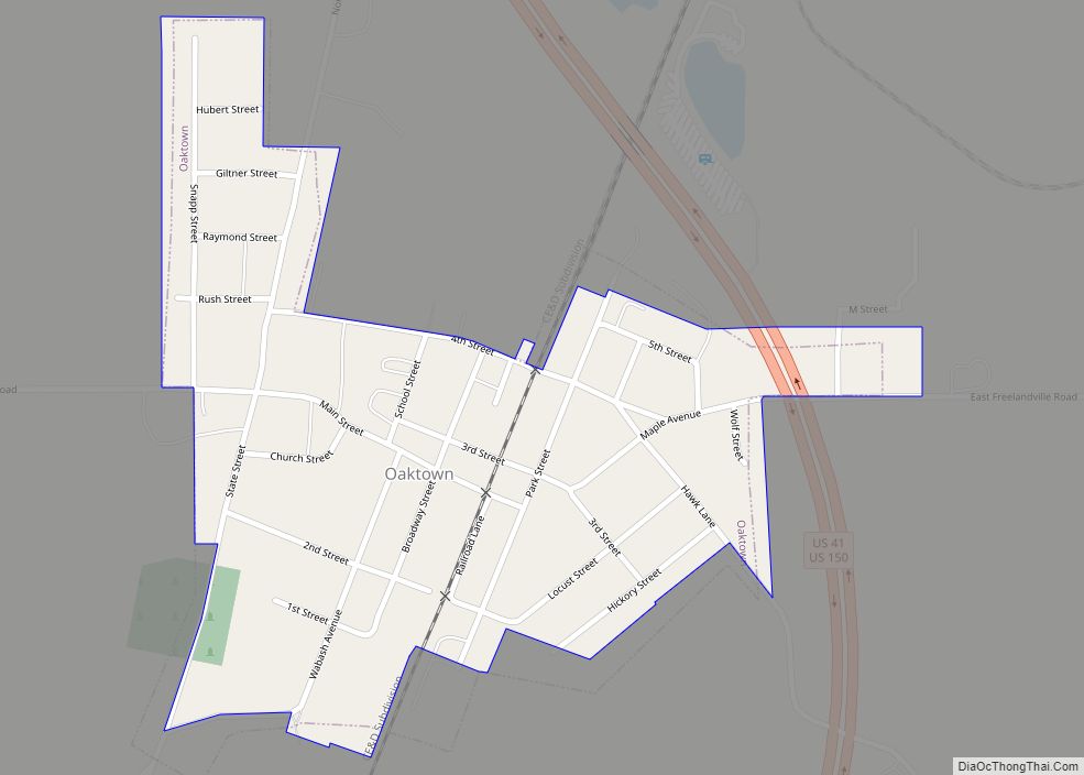
Oaktown is a town in Busseron Township, Knox County, Indiana. The population was 608 at the 2010 census. Oaktown town overview: Name: Oaktown town LSAD Code: 43 LSAD Description: town (suffix) State: Indiana County: Knox County Elevation: 472 ft (144 m) Total Area: 0.27 sq mi (0.70 km²) Land Area: 0.27 sq mi (0.70 km²) Water Area: 0.00 sq mi (0.00 km²) Total Population: 581 Population ... Read more
Onward is a town in Tipton Township, Cass County, Indiana, United States. The population was 100 at the 2010 census. Onward town overview: Name: Onward town LSAD Code: 43 LSAD Description: town (suffix) State: Indiana County: Cass County Elevation: 768 ft (234 m) Total Area: 0.10 sq mi (0.27 km²) Land Area: 0.10 sq mi (0.27 km²) Water Area: 0.00 sq mi (0.00 km²) Total Population: ... Read more
Oldenburg is a town in Ray Township, Franklin County, Indiana, United States. The population was 674 at the 2010 census. Oldenburg town overview: Name: Oldenburg town LSAD Code: 43 LSAD Description: town (suffix) State: Indiana County: Franklin County Elevation: 889 ft (271 m) Total Area: 0.43 sq mi (1.12 km²) Land Area: 0.43 sq mi (1.11 km²) Water Area: 0.00 sq mi (0.01 km²) Total Population: ... Read more
Ogden Dunes is a town in Portage Township, Porter County, in the U.S. state of Indiana. It is located on the shore of Lake Michigan, within Indiana Dunes National Park and nearly surrounded by the city of Portage. The population was 1,110 at the 2010 census. It is named for multi-millionaire Francis A. Ogden, who ... Read more
Orland is a town located in the northwest corner of Steuben County, Indiana in Millgrove Township at the intersection of State Road 120 and State Road 327. The population was 434 at the 2010 census. Orland town overview: Name: Orland town LSAD Code: 43 LSAD Description: town (suffix) State: Indiana County: Steuben County Elevation: 955 ft ... Read more
Orestes is a town in Monroe Township, Madison County, Indiana, United States. It is part of the Indianapolis–Carmel–Anderson metropolitan statistical area. The population was 329 at the 2020 census, down from 414 in 2010. Orestes town overview: Name: Orestes town LSAD Code: 43 LSAD Description: town (suffix) State: Indiana County: Madison County Elevation: 873 ft (266 m) ... Read more
Oolitic is a town in Indian Creek and Shawswick townships, Lawrence County, Indiana, United States. The population was 1,184 at the 2010 census. Oolitic town overview: Name: Oolitic town LSAD Code: 43 LSAD Description: town (suffix) State: Indiana County: Lawrence County Elevation: 600 ft (183 m) Total Area: 0.67 sq mi (1.73 km²) Land Area: 0.67 sq mi (1.73 km²) Water Area: 0.00 sq mi ... Read more
Osgood is a town in Center Township, Ripley County, in the U.S. state of Indiana. The population was 1,624 at the 2010 census. Osgood town overview: Name: Osgood town LSAD Code: 43 LSAD Description: town (suffix) State: Indiana County: Ripley County Elevation: 984 ft (300 m) Total Area: 1.58 sq mi (4.11 km²) Land Area: 1.55 sq mi (4.01 km²) Water Area: 0.04 sq mi ... Read more
Osceola is a town in Penn Township, St. Joseph County, in the U.S. state of Indiana. The population was 2,463 at the 2010 Census. It is part of the South Bend–Mishawaka, IN-MI, Metropolitan Statistical Area. Osceola town overview: Name: Osceola town LSAD Code: 43 LSAD Description: town (suffix) State: Indiana County: St. Joseph County Elevation: ... Read more
Orleans is a town in Orleans Township, Orange County, in the U.S. state of Indiana. The population was 2,142 at the 2010 census. Orleans town overview: Name: Orleans town LSAD Code: 43 LSAD Description: town (suffix) State: Indiana County: Orange County Elevation: 633 ft (193 m) Total Area: 1.71 sq mi (4.43 km²) Land Area: 1.71 sq mi (4.43 km²) Water Area: 0.00 sq mi ... Read more
Otwell is an unincorporated census-designated place in Jefferson Township, Pike County, in the U.S. state of Indiana. Otwell CDP overview: Name: Otwell CDP LSAD Code: 57 LSAD Description: CDP (suffix) State: Indiana County: Pike County Elevation: 499 ft (152 m) Total Area: 1.79 sq mi (4.63 km²) Land Area: 1.78 sq mi (4.62 km²) Water Area: 0.00 sq mi (0.01 km²) Total Population: 396 Population Density: ... Read more