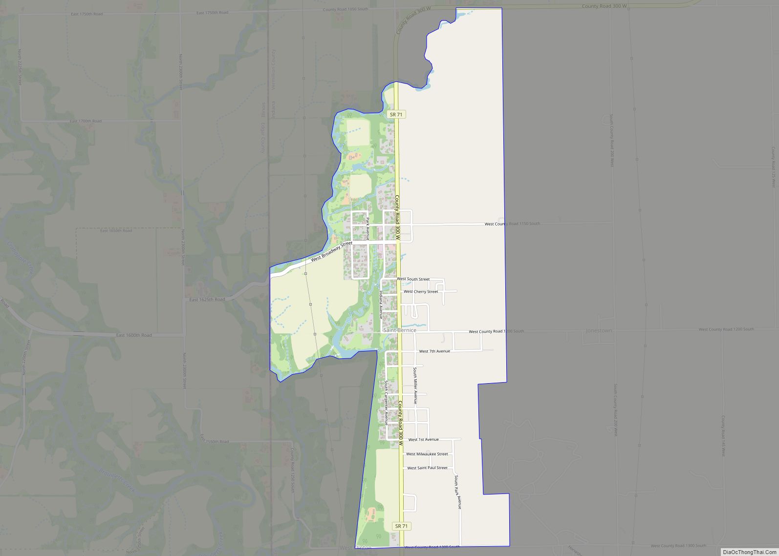
Spurgeon is a town in Monroe Township, Pike County, in the U.S. state of Indiana. The population was 207 at the 2010 census. It is part of the Jasper Micropolitan Statistical Area. Spurgeon town overview: Name: Spurgeon town LSAD Code: 43 LSAD Description: town (suffix) State: Indiana County: Pike County Elevation: 489 ft (149 m) Total Area: ... Read more
Map of US Cities and Places
Springport is a town in Prairie Township, Henry County, Indiana, United States. The population was 149 at the 2010 census. Springport town overview: Name: Springport town LSAD Code: 43 LSAD Description: town (suffix) State: Indiana County: Henry County Elevation: 1,063 ft (324 m) Total Area: 0.12 sq mi (0.31 km²) Land Area: 0.12 sq mi (0.31 km²) Water Area: 0.00 sq mi (0.00 km²) Total Population: ... Read more
St. Leon is a town in Kelso Township, Dearborn County, Indiana, United States. The population was 678 at the 2010 census. It is also home to a wiffleball tournament, Wifflerama. St. Leon town overview: Name: St. Leon town LSAD Code: 43 LSAD Description: town (suffix) State: Indiana County: Dearborn County Total Area: 6.84 sq mi (17.71 km²) Land ... Read more
St. John town overview: Name: St. John town LSAD Code: 43 LSAD Description: town (suffix) State: Indiana County: Lake County FIPS code: 1866852 Online Interactive Map St. John online map. Source: Basemap layers from Google Map, Open Street Map (OSM), Arcgisonline, Wmflabs. Boundary Data from Database of Global Administrative Areas. St. John location map. Where ... Read more
Saint Joe is a town in Concord Township, DeKalb County, Indiana, United States. The population was 460 at the 2010 census. St. Joe town overview: Name: St. Joe town LSAD Code: 43 LSAD Description: town (suffix) State: Indiana County: DeKalb County Total Area: 0.34 sq mi (0.87 km²) Land Area: 0.34 sq mi (0.87 km²) Water Area: 0.00 sq mi (0.00 km²) Total Population: ... Read more
St. Paul is a small town on the border of Decatur and Shelby counties in the U.S. state of Indiana. The population was 1,031 at the 2010 census. St. Paul town overview: Name: St. Paul town LSAD Code: 43 LSAD Description: town (suffix) State: Indiana County: Decatur County, Shelby County Elevation: 856 ft (261 m) Total Area: ... Read more
Saint Meinrad is a census-designated place (CDP) in Harrison Township, Spencer County, Indiana, United States. Located along the Anderson River, it is home to the St. Meinrad Archabbey. Interstate 64 runs near the CDP, and it is situated about 55 miles east of Evansville. Because of the archabbey, St. Meinrad, along with Harrison Township, is ... Read more
Saint Mary-of-the-Woods, often called St. Mary’s, is an unincorporated community in Sugar Creek Township in northwestern Vigo County, in the U.S. state of Indiana. The community is part of the Terre Haute Metropolitan Statistical Area. A large portion of Saint Mary-of-the-Woods along U.S. Route 150 is taken up by the grounds of the Sisters of ... Read more
Staunton is a town in Posey Township, Clay County, Indiana, United States. The population was 534 at the 2010 census. It is part of the Terre Haute Metropolitan Statistical Area. Staunton town overview: Name: Staunton town LSAD Code: 43 LSAD Description: town (suffix) State: Indiana County: Clay County Elevation: 646 ft (197 m) Total Area: 0.33 sq mi (0.85 km²) ... Read more
State Line City is a town in Kent Township, Warren County, Indiana, United States, situated along the state’s boundary with Illinois. As of the 2010 census, the town population was 143. State Line City town overview: Name: State Line City town LSAD Code: 43 LSAD Description: town (suffix) State: Indiana County: Warren County Founded: 1857 ... Read more
Star City is a census-designated place (CDP) in Van Buren Township, Pulaski County, in the U.S. state of Indiana. The population was 344 at the 2010 census. Star City CDP overview: Name: Star City CDP LSAD Code: 57 LSAD Description: CDP (suffix) State: Indiana County: Pulaski County Elevation: 715 ft (218 m) Total Area: 1.04 sq mi (2.68 km²) Land ... Read more
Stinesville is a town in Bean Blossom Township, Monroe County, in the U.S. state of Indiana. The population was 203 at the 2020 census. It is part of the Bloomington Metropolitan Statistical Area. Stinesville town overview: Name: Stinesville town LSAD Code: 43 LSAD Description: town (suffix) State: Indiana County: Monroe County Elevation: 581 ft (177 m) Total ... Read more