Map of Kincaid city, Kansas
Kincaid is a city in Anderson County, Kansas, United States. As of the 2020 census, the population of the city was 103. Kincaid city overview: Name: Kincaid city LSAD Code: 25 LSAD Description: city (suffix) State: Kansas County: Anderson County Founded: 1885 Incorporated: 1886 Elevation: 1,056 ft (322 m) Total Area: 0.50 sq mi (1.30 km²) Land Area: 0.50 sq mi (1.30 km²) ... Read more
Map of Kincaid city, Kansas
Map of Kinsley city
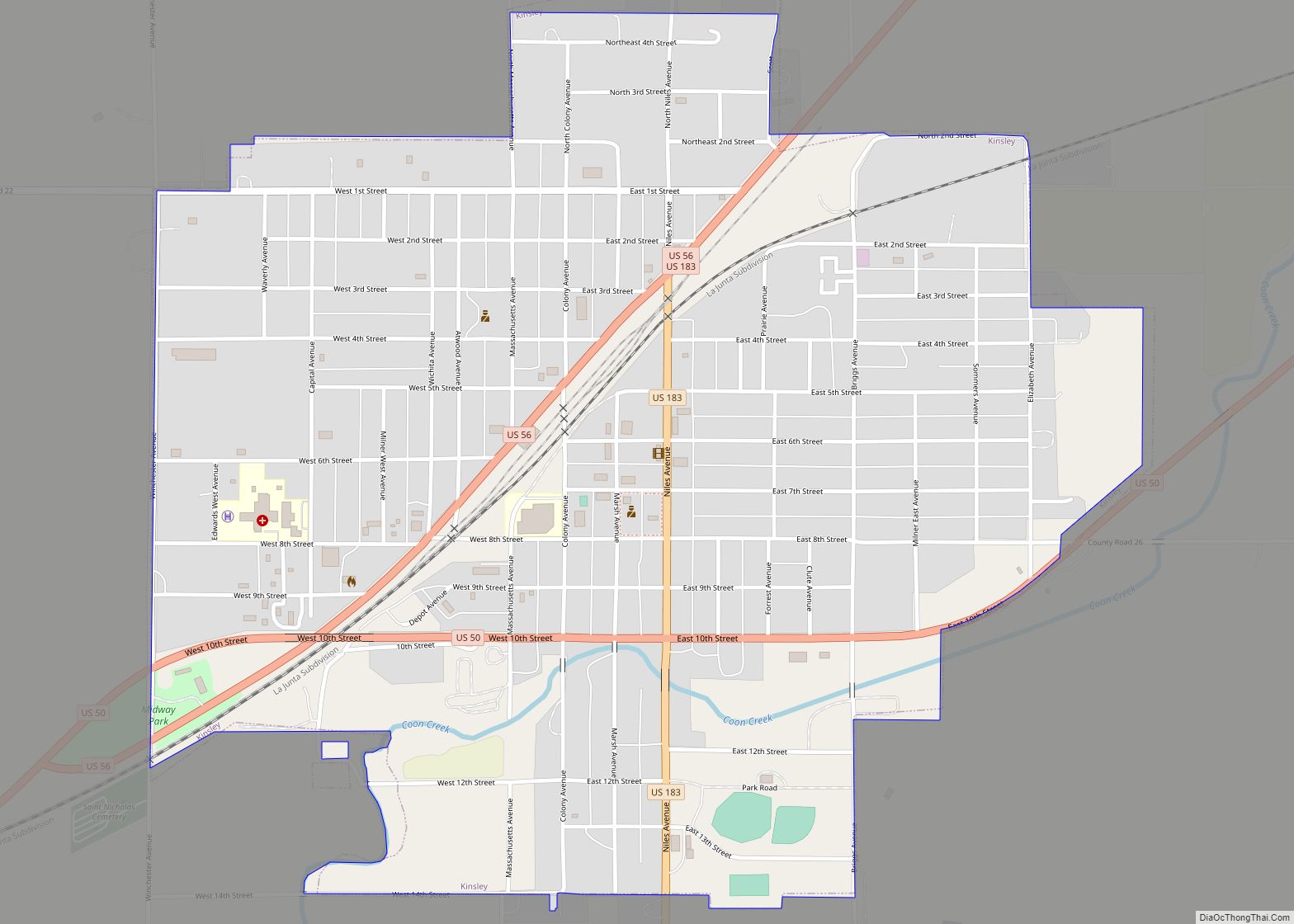
Kinsley is a city in and the county seat of Edwards County, Kansas, United States. As of the 2020 census, the population of the city was 1,456. Kinsley city overview: Name: Kinsley city LSAD Code: 25 LSAD Description: city (suffix) State: Kansas County: Edwards County Founded: 1870s Incorporated: 1878 Elevation: 2,169 ft (661 m) Total Area: 1.30 sq mi ... Read more
Map of Kinsley city
Map of Kingman city, Kansas
Kingman is a city in and the county seat of Kingman County, Kansas, United States. As of the 2020 census, the population of the city was 3,105. Kingman city overview: Name: Kingman city LSAD Code: 25 LSAD Description: city (suffix) State: Kansas County: Kingman County Founded: 1870s Incorporated: 1883 Elevation: 1,519 ft (463 m) Total Area: 3.47 sq mi ... Read more
Map of Kingman city, Kansas
Map of Kirwin city
Kirwin is a city in Phillips County, Kansas, United States. As of the 2020 census, the population of the city was 139. Kirwin city overview: Name: Kirwin city LSAD Code: 25 LSAD Description: city (suffix) State: Kansas County: Phillips County Founded: 1869 Incorporated: 1877 Elevation: 1,700 ft (500 m) Total Area: 0.92 sq mi (2.37 km²) Land Area: 0.92 sq mi (2.37 km²) ... Read more
Map of Kirwin city
Map of Kipp CDP
Kipp is an unincorporated community on the border between Eureka and Solomon townships in Saline County, Kansas, United States. As of the 2020 census, the population of the community and nearby areas was 60. It is located southeast of Salina along Schilling Road between Whitmore Road and Kipp Road, next to an abandoned railroad. Kipp ... Read more
Map of Kipp CDP
Map of Kiowa city, Kansas
Kiowa is a city in Barber County, Kansas, United States. As of the 2020 census, the population of the city was 902. It is located 1 mile north of the Kansas / Oklahoma state border. Kiowa city overview: Name: Kiowa city LSAD Code: 25 LSAD Description: city (suffix) State: Kansas County: Barber County Founded: 1872 ... Read more
Map of Kiowa city, Kansas
Map of La Cygne city
La Cygne (pronounced /leɪ ˈsiːn/ lay SEEN) is a city in Linn County, Kansas, United States, and situated along the Marais des Cygnes River. As of the 2020 census, the population of the city was 1,050. The city is named after the Marais des Cygnes River which is a French translation of an Osage appellation ... Read more
Map of La Cygne city
Map of La Crosse city, Kansas
La Crosse is a city in and the county seat of Rush County, Kansas, United States. As of the 2020 census, the population of the city was 1,266. La Crosse proclaims itself the “Barbed Wire capital of the world. La Crosse city overview: Name: La Crosse city LSAD Code: 25 LSAD Description: city (suffix) State: ... Read more
Map of La Crosse city, Kansas
Map of Kismet city
Kismet is a city in Seward County, Kansas, United States. As of the 2020 census, the population of the city was 340. Kismet city overview: Name: Kismet city LSAD Code: 25 LSAD Description: city (suffix) State: Kansas County: Seward County Founded: 1880s Incorporated: 1929 Elevation: 2,779 ft (847 m) Total Area: 0.24 sq mi (0.61 km²) Land Area: 0.24 sq mi (0.61 km²) ... Read more
Map of Kismet city
Map of Lake Quivira city
Lake Quivira /ˈleɪk kwɪˈvɪərə/ is a city in Johnson and Wyandotte counties in the State of Kansas, and part of the Kansas City Metropolitan Area. As of the 2020 census, the population of the city was 1,014. Lake Quivira city overview: Name: Lake Quivira city LSAD Code: 25 LSAD Description: city (suffix) State: Kansas County: ... Read more
Map of Lake Quivira city
Map of Labette city
Labette is a city in Labette County, Kansas, United States. As of the 2020 census, the population of the city was 50. Labette city overview: Name: Labette city LSAD Code: 25 LSAD Description: city (suffix) State: Kansas County: Labette County Founded: 1870 Incorporated: 1919 Elevation: 866 ft (264 m) Total Area: 0.22 sq mi (0.58 km²) Land Area: 0.22 sq mi (0.58 km²) ... Read more
Map of Labette city
Map of La Harpe city, Kansas
La Harpe is a city in Allen County, Kansas, United States. As of the 2020 census, the population of the city was 480. La Harpe city overview: Name: La Harpe city LSAD Code: 25 LSAD Description: city (suffix) State: Kansas County: Allen County Founded: 1881 Incorporated: 1905 Elevation: 1,034 ft (315 m) Total Area: 0.80 sq mi (2.08 km²) Land ... Read more
Map of La Harpe city, Kansas