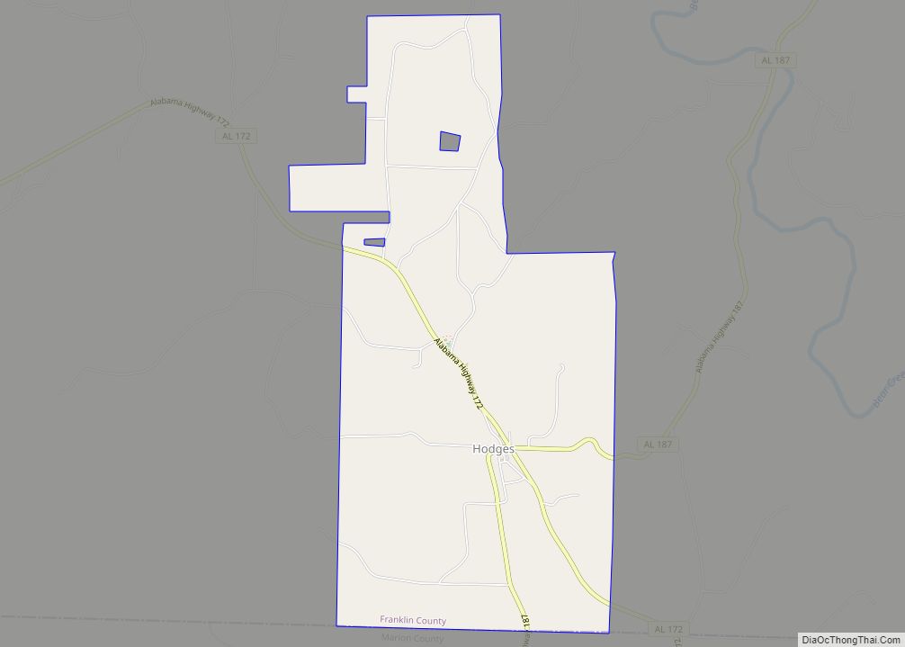
Map of Hobson CDP

Map of Hobson CDP, Alabama

Hobson is a census-designated place and unincorporated community in Washington County, Alabama, United States. Its population was 126 as of the 2010 census. Hobson CDP overview: Name: Hobson CDP LSAD Code: 57 LSAD Description: CDP (suffix) State: Alabama County: Washington County Elevation: 148 ft (45 m) Total Area: 2.97 sq mi (7.70 km²) Land Area: 2.94 sq mi (7.63 km²) Water Area: 0.03 sq mi … Read more

Map of Hobson City town

Map of Hobson City town

Hobson City is a town in Calhoun County, Alabama, United States. At the 2020 census, the population was 759. It is included in the Anniston-Oxford Metropolitan Statistical Area. Hobson City was Alabama’s first self-governed all-black municipality. Hobson City town overview: Name: Hobson City town LSAD Code: 43 LSAD Description: town (suffix) State: Alabama County: Calhoun … Read more

Map of Hollis Crossroads CDP

Map of Hollis Crossroads CDP

Hollis Crossroads is a census-designated place and unincorporated community in Cleburne County, Alabama, United States. Its population was 665 as of the 2020 census. Hollis Crossroads is located along U.S. Route 431 between Anniston and Wedowee and Alabama State Route 9 between Lineville to Heflin; Routes 431 and 9 intersect here. The Pleasant Grove Elementary … Read more

Map of Hollins CDP

Map of Hollins CDP, Alabama

Hollins is a census-designated place and unincorporated community in Clay County, Alabama, United States. Its population was 517 as of the 2020 census. Hollins CDP overview: Name: Hollins CDP LSAD Code: 57 LSAD Description: CDP (suffix) State: Alabama County: Clay County Elevation: 827 ft (252 m) Total Area: 11.88 sq mi (30.76 km²) Land Area: 11.85 sq mi (30.68 km²) Water Area: 0.03 sq mi … Read more

Map of Hokes Bluff city

Map of Hokes Bluff city

Hokes Bluff is a city in Etowah County, Alabama, United States. It is part of the Gadsden Metropolitan Statistical Area. At the 2020 census, the population was 4,446. Hokes Bluff city overview: Name: Hokes Bluff city LSAD Code: 25 LSAD Description: city (suffix) State: Alabama County: Etowah County Elevation: 587 ft (179 m) Total Area: 12.09 sq mi (31.32 km²) … Read more

Map of Holt CDP

Map of Holt CDP, Alabama

Holt is an unincorporated community and census-designated place (CDP) in Tuscaloosa County, Alabama, United States. At the 2020 census, the population was 3,413. It is part of the Tuscaloosa, Alabama Metropolitan Statistical Area. Holt appeared on the 1930 census. Holt CDP overview: Name: Holt CDP LSAD Code: 57 LSAD Description: CDP (suffix) State: Alabama County: … Read more

Map of Hollywood city

Map of Hollywood town, Alabama

Hollywood is a town in Jackson County, northeast Alabama, United States. In 2020, the census showed a population of 914 residents. Hollywood is considered a suburb of Scottsboro, the county seat. The town is the site of the Tennessee Valley Authority’s never-completed Bellefonte Nuclear Generating Station. The TVA sold the plant, and as of 2018, … Read more

Map of Holly Pond town

Map of Holly Pond town

Holly Pond is a town in Cullman County, Alabama, United States. As of the 2010 census the town’s population was 798. The town was incorporated in 1906. Holly Pond town overview: Name: Holly Pond town LSAD Code: 43 LSAD Description: town (suffix) State: Alabama County: Cullman County Elevation: 866 ft (264 m) Total Area: 3.93 sq mi (10.18 km²) Land … Read more

Map of Hoover city

Map of Hoover city

Hoover is a city in Jefferson and Shelby counties in north central Alabama, United States. Hoover is the largest suburban city in Alabama and the 6th largest city in Alabama. The city had a population of 92,606 as of the 2020 US Census. Hoover is part of the Birmingham-Hoover, AL Metropolitan Statistical Area and is … Read more

Map of Homewood city

Map of Homewood city, Alabama

Homewood is a city in southeastern Jefferson County, Alabama, United States. It is a suburb of Birmingham, located on the other side of Red Mountain due south of the city center. As of the 2010 census its population was 25,167, and in 2019 the estimated population was 25,377. Homewood city overview: Name: Homewood city LSAD … Read more

Map of Holtville CDP

Map of Holtville CDP, Alabama

Holtville (also Slapout) is a census-designated place and unincorporated community in Elmore County, Alabama, United States. Its population was 4,940 as of the 2020 census. Holtville/Slapout is located on the western bank of Lake Jordan, and much of its population lives along this lakeshore, or in the neighboring Lightwood community. According to tradition, the old … Read more

Map of Huguley CDP

Map of Huguley CDP

Huguley (/ˈhjuːɡəli/ HEW-goo-lee) is a census-designated place (CDP) and unincorporated community in Chambers County, Alabama, United States. At the 2020 census, the population was 2,470. Huguley CDP overview: Name: Huguley CDP LSAD Code: 57 LSAD Description: CDP (suffix) State: Alabama County: Chambers County Elevation: 702 ft (214 m) Total Area: 8.27 sq mi (21.42 km²) Land Area: 8.27 sq mi (21.42 km²) Water … Read more