Map of Keachi town
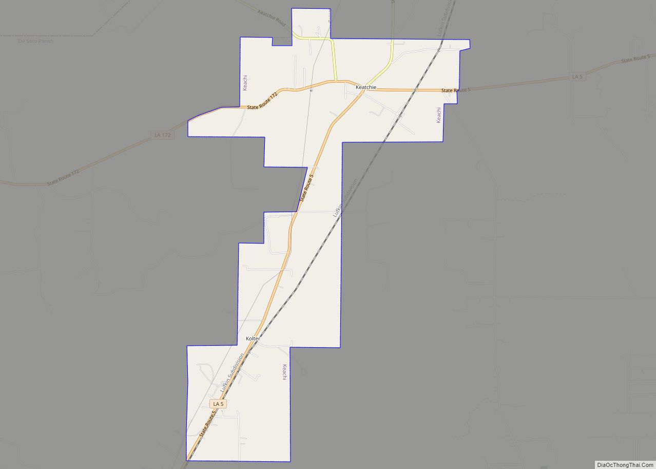
Keachi (pronounced “key-chai”; also spelled Keatchie or Keachie) is a town in DeSoto Parish, Louisiana, United States. The population was 295 at the 2010 census. It is part of the Shreveport–Bossier City Metropolitan Statistical Area. Keachi town overview: Name: Keachi town LSAD Code: 43 LSAD Description: town (suffix) State: Louisiana County: De Soto Parish Elevation: ... Read more
Map of Keachi town
Map of Kaplan city
Kaplan is a city in Vermilion Parish, Louisiana, United States. The population was 4,600 at the 2010 census, and 4,345 at the 2020 population estimates program. It is part of the Abbeville micropolitan statistical area in Acadiana. Kaplan city overview: Name: Kaplan city LSAD Code: 25 LSAD Description: city (suffix) State: Louisiana County: Vermilion Parish ... Read more
Map of Kaplan city
Map of Junction City village, Louisiana
Junction City is a village in Claiborne and Union parishes in Louisiana, United States, and is the twin city of neighboring Junction City, Arkansas. The population was 437 in 2020. The Union Parish portion of Junction City is part of the Monroe Metropolitan Statistical Area. Junction City village overview: Name: Junction City village LSAD Code: ... Read more
Map of Junction City village, Louisiana
Map of Kilbourne village, Louisiana
Kilbourne is a village in West Carroll Parish, Louisiana, United States. The population was 416 at the 2010 census. Kilbourne village overview: Name: Kilbourne village LSAD Code: 47 LSAD Description: village (suffix) State: Louisiana County: West Carroll Parish Elevation: 125 ft (38 m) Total Area: 1.39 sq mi (3.59 km²) Land Area: 1.39 sq mi (3.59 km²) Water Area: 0.00 sq mi (0.00 km²) Total Population: ... Read more
Map of Kilbourne village, Louisiana
Map of Kentwood town, Louisiana
Kentwood is a rural town in Tangipahoa Parish, Louisiana, United States, near the Mississippi state line. The population was 2,198 at the 2010 census. It is part of the Hammond Micropolitan Statistical Area. Kentwood is best known as the hometown of singer Britney Spears. Kentwood town overview: Name: Kentwood town LSAD Code: 43 LSAD Description: ... Read more
Map of Kentwood town, Louisiana
Map of Kenner city
Kenner is a city in Louisiana, United States. It is the largest city in Jefferson Parish, and is the largest incorporated suburban city of New Orleans. The population was 66,448 at the 2020 census. Kenner city overview: Name: Kenner city LSAD Code: 25 LSAD Description: city (suffix) State: Louisiana County: Jefferson Parish Founded: March 2, ... Read more
Map of Kenner city
Map of Killian town
Killian is a town in Livingston Parish, Louisiana, United States. The population was 1,206 at the 2010 census. It is part of the Baton Rouge Metropolitan Statistical Area. Killian town overview: Name: Killian town LSAD Code: 43 LSAD Description: town (suffix) State: Louisiana County: Livingston Parish Elevation: 13 ft (4 m) Total Area: 10.90 sq mi (28.23 km²) Land Area: ... Read more
Map of Killian town
Map of Kinder town
Kinder is a small town in Allen Parish, Louisiana, in the United States. The population was 2,477 at the 2010 census. The Lieutenant Douglas B. Fournet Memorial Park, an American Legion enterprise, was dedicated on June 11, 1988, in Kinder to remember those who died in military service to the nation. Kinder was the birthplace ... Read more
Map of Kinder town
Map of Killona CDP
Killona is a census-designated place (CDP) in St. Charles Parish, Louisiana, United States. The population was 724 in 2020. On December 14, 2022, the town was hit by a destructive and deadly EF2 tornado that damaged or destroyed numerous structures, killed one person, and injured eight others. Killona CDP overview: Name: Killona CDP LSAD Code: ... Read more
Map of Killona CDP
Map of Labadieville CDP
Labadieville is a census-designated place (CDP) in Assumption Parish, Louisiana, United States. The population was 1,854 at the 2010 census. It is part of the Pierre Part Micropolitan Statistical Area. Labadieville CDP overview: Name: Labadieville CDP LSAD Code: 57 LSAD Description: CDP (suffix) State: Louisiana County: Assumption Parish Elevation: 16 ft (5 m) Total Area: 3.89 sq mi (10.07 km²) ... Read more
Map of Labadieville CDP
Map of Krotz Springs town
Krotz Springs is a town in St. Landry Parish, Louisiana, United States, on the Atchafalaya River. The population was 1,198 at the 2010 census, down from 1,219 in 2000. It is part of the Opelousas–Eunice Micropolitan Statistical Area. Krotz Springs town overview: Name: Krotz Springs town LSAD Code: 43 LSAD Description: town (suffix) State: Louisiana ... Read more
Map of Krotz Springs town
Map of Kraemer CDP
Kraemer is a census-designated place (CDP) in Lafourche Parish, Louisiana, United States. As of the 2010 census, its population was 934. Its ZIP code is 70371. It is also known as Bayou Boeuf. Kraemer CDP overview: Name: Kraemer CDP LSAD Code: 57 LSAD Description: CDP (suffix) State: Louisiana County: Lafourche Parish Elevation: 3 ft (0.9 m) Total ... Read more
Map of Kraemer CDP