Map of Lafitte CDP
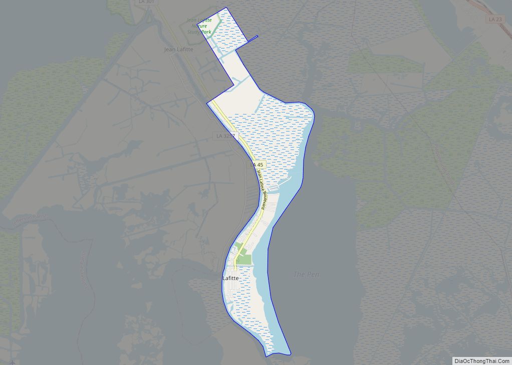
Lafitte is an unincorporated community and census-designated place (CDP) in Jefferson Parish, Louisiana, United States. The population was 972 at the 2010 census, and 816 in 2019. In 2020, its population increased to 1,014 people. It is part of the New Orleans–Metairie–Kenner metropolitan statistical area. Lafitte is located at the southern end of Louisiana Highway ... Read more
Map of Lafitte CDP
Map of Lacombe CDP
Lacombe is a census-designated place (CDP) in St. Tammany Parish, Louisiana, United States. The population was 8,679 at the 2010 census. Lacombe CDP overview: Name: Lacombe CDP LSAD Code: 57 LSAD Description: CDP (suffix) State: Louisiana County: St. Tammany Parish Elevation: 13 ft (4 m) Total Area: 27.51 sq mi (71.25 km²) Land Area: 26.45 sq mi (68.50 km²) Water Area: 1.06 sq mi (2.75 km²) ... Read more
Map of Lacombe CDP
Map of Lacassine CDP
Lacassine (French: La Cassine) is an unincorporated community and census-designated place (CDP) in Jefferson Davis Parish in the U.S. state of Louisiana. As of the 2010 census the population was 480. Lacassine CDP overview: Name: Lacassine CDP LSAD Code: 57 LSAD Description: CDP (suffix) State: Louisiana County: Jefferson Davis Parish Elevation: 21 ft (6 m) Total Area: ... Read more
Map of Lacassine CDP
Map of Lake Providence town
Lake Providence is a town in, and the parish seat of, East Carroll Parish in northeastern Louisiana. The population was 5,104 at the 2000 census and declined by 21.8 percent to 3,991 in 2010. The town’s poverty rate is approximately 55 percent; the average median household income is $16,500, and the average age is 31. ... Read more
Map of Lake Providence town
Map of Lake Arthur town, Louisiana
Lake Arthur is a town in Jefferson Davis Parish, Louisiana, United States. The population was 2,738 at the 2010 census, down from 3,007 at the 2000 census. It is part of the Jennings Micropolitan Statistical Area. The current mayor is Sherry Crochet. Lake Arthur town overview: Name: Lake Arthur town LSAD Code: 43 LSAD Description: ... Read more
Map of Lake Arthur town, Louisiana
Map of Lafourche Crossing CDP
Lafourche Crossing (also known as Lafourche) is an unincorporated community and census-designated place in Lafourche Parish, Louisiana, United States. Its population was 2,002 as of the 2010 census. Louisiana Highway 1 passes through the community. Lafourche Crossing CDP overview: Name: Lafourche Crossing CDP LSAD Code: 57 LSAD Description: CDP (suffix) State: Louisiana County: Lafourche Parish ... Read more
Map of Lafourche Crossing CDP
Map of Laplace CDP, Louisiana
LaPlace (/ləˈplɑːs/ lə-PLAHSS) is a census-designated place (CDP) in St. John the Baptist Parish, Louisiana, United States, situated along the east bank of the Mississippi River, in the New Orleans metropolitan area. In 2020, it had a population of 28,841. LaPlace is the southern terminus of Interstate 55, where it joins with Interstate 10, and ... Read more
Map of Laplace CDP, Louisiana
Map of Lakeview CDP, Louisiana
Lakeview is an unincorporated community and census-designated place (CDP) in Caddo Parish, Louisiana, United States. As of the 2010 census it had a population of 948. It is located on the north shore of Cross Lake 5 miles (8 km) northwest of downtown Shreveport. It is bordered by the city limits of Shreveport to the north, ... Read more
Map of Lakeview CDP, Louisiana
Map of Lakeshore CDP
Lakeshore is an unincorporated community and census-designated place in Ouachita Parish, Louisiana, United States. Its population was 1,930 as of the 2010 census. The community is located on the south bank of Bayou Desiard, east of Monroe. Lakeshore CDP overview: Name: Lakeshore CDP LSAD Code: 57 LSAD Description: CDP (suffix) State: Louisiana County: Ouachita Parish ... Read more
Map of Lakeshore CDP
Map of Lecompte town
Lecompte (/ləˈkaʊnt/ lə-KOWNT) is a town in Rapides Parish, Louisiana, United States. Lecompte is situated along the banks of the Red River in central Louisiana. US Highway 71, Louisiana’s major north-south route which connects Baton Rouge and Shreveport, runs through Lecompte. Lecompte is named after a horse called LeComte, which was named after horse breeder ... Read more
Map of Lecompte town
Map of Lawtell CDP
Lawtell is an unincorporated community and census-designated place in St. Landry Parish, Louisiana, United States. The name is a portmanteau of the names of its two founders: Lawler and Littell. State Representative Dustin Miller is a native of and a businessman in Lawtell. Lawtell CDP overview: Name: Lawtell CDP LSAD Code: 57 LSAD Description: CDP ... Read more
Map of Lawtell CDP
Map of Larose CDP
Larose is an unincorporated community and census-designated place (CDP) in Lafourche Parish, Louisiana, United States. The population was 6,763 in 2020. It is part of the Houma–Bayou Cane–Thibodaux metropolitan statistical area. Larose CDP overview: Name: Larose CDP LSAD Code: 57 LSAD Description: CDP (suffix) State: Louisiana County: Lafourche Parish Elevation: 8 ft (2 m) Total Area: 11.17 sq mi ... Read more
Map of Larose CDP