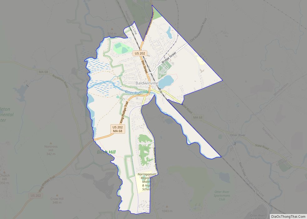
Baldwinville is an unincorporated village and census-designated place (CDP) in the town of Templeton in Worcester County, Massachusetts, United States. The population was 2,028 at the 2010 census. The name also refers to the local post office or railroad station. Baldwinville CDP overview: Name: Baldwinville CDP LSAD Code: 57 LSAD Description: CDP (suffix) State: Massachusetts ... Read more
Map of US Cities and Places
Belmont is a town in Middlesex County, Massachusetts, United States. It is a western suburb of Boston, Massachusetts, United States; and is part of the Greater Boston metropolitan area. At the 2020 U.S. census, its population was 27,295, up 10.4% from 2010. Belmont CDP overview: Name: Belmont CDP LSAD Code: 57 LSAD Description: CDP (suffix) ... Read more
Bellingham is a census-designated place (CDP) in the town of Bellingham in Norfolk County, Massachusetts, United States. The population was 4,854 at the 2010 census. Bellingham CDP overview: Name: Bellingham CDP LSAD Code: 57 LSAD Description: CDP (suffix) State: Massachusetts County: Norfolk County Elevation: 295 ft (90 m) Total Area: 5.49 sq mi (14.22 km²) Land Area: 5.39 sq mi (13.96 km²) Water ... Read more
Belchertown is a census-designated place (CDP) comprising the central village in the town of Belchertown in Hampshire County, Massachusetts, United States. The population was 2,899 at the 2010 census, out of a total town population of 14,649. It is part of the Springfield, Massachusetts Metropolitan Statistical Area. Belchertown CDP overview: Name: Belchertown CDP LSAD Code: ... Read more
Beverly is a city in Essex County, Massachusetts, and a suburb of Boston. The population was 42,670 at the time of the 2020 United States Census. A resort, residential, and manufacturing community on the Massachusetts North Shore, Beverly includes Ryal Side, North Beverly, Montserrat, Beverly Farms and Prides Crossing. Beverly is a rival of Marblehead ... Read more
Bliss Corner is a census-designated place (CDP) in the town of Dartmouth in Bristol County, Massachusetts, United States. The population was 5,280 at the 2010 census. Bliss Corner CDP overview: Name: Bliss Corner CDP LSAD Code: 57 LSAD Description: CDP (suffix) State: Massachusetts County: Bristol County Elevation: 66 ft (20 m) Total Area: 2.00 sq mi (5.19 km²) Land Area: ... Read more
Blandford is a census-designated place that comprises the populated center of the town of Blandford in Hampden County, Massachusetts, United States. The population of the CDP was 393 at the 2010 census, out of 1,233 in the entire town of Blandford. It is part of the Springfield, Massachusetts Metropolitan Statistical Area. Blandford CDP overview: Name: ... Read more
Braintree Town city overview: Name: Braintree Town city LSAD Code: 25 LSAD Description: city (suffix) State: Massachusetts County: Norfolk County FIPS code: 2507740 Online Interactive Map Braintree Town online map. Source: Basemap layers from Google Map, Open Street Map (OSM), Arcgisonline, Wmflabs. Boundary Data from Database of Global Administrative Areas. Braintree Town location map. Where ... Read more
Boxford is a census-designated place (CDP) in the town of Boxford in Essex County, Massachusetts, United States. The population was 2,339 at the 2010 census. Boxford CDP overview: Name: Boxford CDP LSAD Code: 57 LSAD Description: CDP (suffix) State: Massachusetts County: Essex County Elevation: 102 ft (31 m) Total Area: 5.47 sq mi (14.18 km²) Land Area: 5.36 sq mi (13.89 km²) Water ... Read more
The village of Bourne is a census-designated place (CDP) in the town of Bourne in Barnstable County, Massachusetts, United States. The population was 1,418 at the 2010 census, out of 19,754 in the town of Bourne as a whole. Bourne CDP overview: Name: Bourne CDP LSAD Code: 57 LSAD Description: CDP (suffix) State: Massachusetts County: ... Read more
Brookfield is a census-designated place (CDP) comprising the main village in the town of Brookfield, Worcester County, Massachusetts, United States. Massachusetts Route 9 passes through the center of the village, leading east 6 miles (10 km) to Spencer and west 9 miles (14 km) to Ware. Massachusetts Route 148 crosses Route 9 in the village center, leading ... Read more
Bridgewater Town city overview: Name: Bridgewater Town city LSAD Code: 25 LSAD Description: city (suffix) State: Massachusetts FIPS code: 2508130 Online Interactive Map Bridgewater Town online map. Source: Basemap layers from Google Map, Open Street Map (OSM), Arcgisonline, Wmflabs. Boundary Data from Database of Global Administrative Areas. Bridgewater Town location map. Where is Bridgewater Town ... Read more