Map of Housatonic CDP
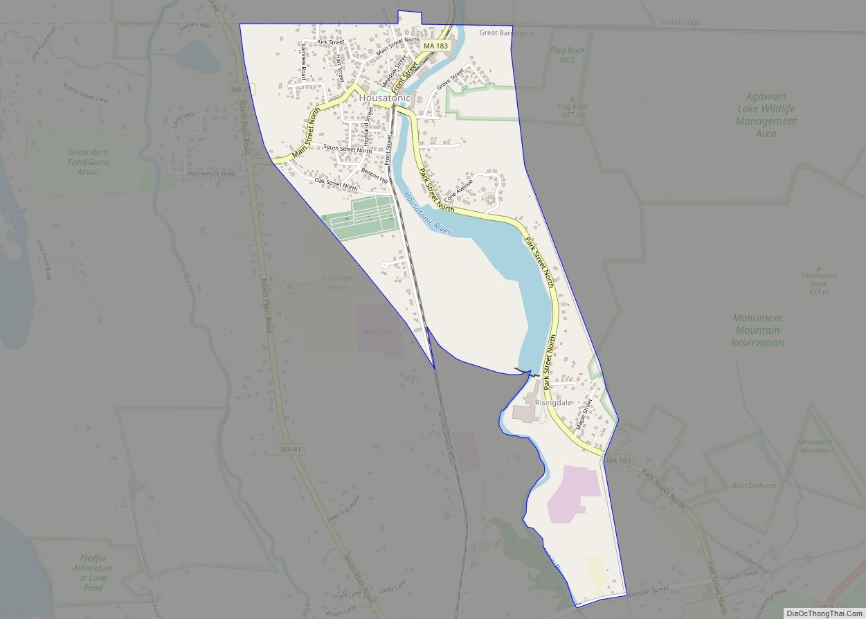
Housatonic is a census-designated place (CDP) in the town of Great Barrington in Berkshire County, Massachusetts. It is part of the Pittsfield, Massachusetts Metropolitan Statistical Area. The population was 1,109 at the 2010 census. It was named after the Housatonic River. Housatonic CDP overview: Name: Housatonic CDP LSAD Code: 57 LSAD Description: CDP (suffix) State: ... Read more
Map of Housatonic CDP
Map of Kingston CDP, Massachusetts
Kingston is a census-designated place (CDP) in the town of Kingston in Plymouth County, Massachusetts, United States. The population was 5,591 at the 2010 census. Kingston CDP overview: Name: Kingston CDP LSAD Code: 57 LSAD Description: CDP (suffix) State: Massachusetts County: Plymouth County Elevation: 59 ft (18 m) Total Area: 6.28 sq mi (16.27 km²) Land Area: 4.81 sq mi (12.46 km²) Water ... Read more
Map of Kingston CDP, Massachusetts
Map of Ipswich CDP, Massachusetts
Ipswich is a census-designated place (CDP) located in the town of Ipswich in Essex County, Massachusetts, United States. The population was 4,222 at the 2010 census. Ipswich CDP overview: Name: Ipswich CDP LSAD Code: 57 LSAD Description: CDP (suffix) State: Massachusetts County: Essex County Elevation: 26 ft (8 m) Total Area: 1.74 sq mi (4.51 km²) Land Area: 1.64 sq mi (4.25 km²) ... Read more
Map of Ipswich CDP, Massachusetts
Map of Huntington CDP, Massachusetts
Huntington is a census-designated place (CDP) comprising the main village in the town of Huntington in Hampshire County, Massachusetts, United States. The population of the CDP was 936 at the 2010 census, out of a total town population of 2,180. It is part of the Springfield, Massachusetts Metropolitan Statistical Area. Huntington CDP overview: Name: Huntington ... Read more
Map of Huntington CDP, Massachusetts
Map of Lawrence city, Massachusetts
Lawrence city overview: Name: Lawrence city LSAD Code: 25 LSAD Description: city (suffix) State: Massachusetts County: Essex County Incorporated: 1847 Elevation: 16 ft (5 m) Total Area: 7.43 sq mi (19.24 km²) Land Area: 6.93 sq mi (17.95 km²) Water Area: 0.50 sq mi (1.29 km²) Total Population: 89,143 Population Density: 12,863.35/sq mi (4,966.73/km²) Area code: 351/978 FIPS code: 2534550 Website: www.cityoflawrence.com Online Interactive Map Lawrence online ... Read more
Map of Lawrence city, Massachusetts
Map of Lenox CDP, Massachusetts
Lenox, also known as Lenox Center, is a census-designated place (CDP) in the town of Lenox in Berkshire County, Massachusetts, United States. The population was 1,675 at the 2010 census, out of 5,025 in the entire town of Lenox. Lenox CDP overview: Name: Lenox CDP LSAD Code: 57 LSAD Description: CDP (suffix) State: Massachusetts County: ... Read more
Map of Lenox CDP, Massachusetts
Map of Lee CDP, Massachusetts
Lee is a census-designated place (CDP) located in the town of Lee in Berkshire County, Massachusetts, United States. The population was 2,051 at the 2010 census, out of 5,943 in the entire town of Lee. Lee CDP overview: Name: Lee CDP LSAD Code: 57 LSAD Description: CDP (suffix) State: Massachusetts County: Berkshire County Elevation: 883 ft ... Read more
Map of Lee CDP, Massachusetts
Map of Littleton Common CDP
Littleton Common is a census-designated place (CDP) in the town of Littleton in Middlesex County, Massachusetts, United States. The population was 2,789 at the 2010 census. Littleton Common CDP overview: Name: Littleton Common CDP LSAD Code: 57 LSAD Description: CDP (suffix) State: Massachusetts County: Middlesex County Elevation: 266 ft (81 m) Total Area: 3.70 sq mi (9.59 km²) Land Area: ... Read more
Map of Littleton Common CDP
Map of Lexington CDP, Massachusetts
Lexington is a suburban town in Middlesex County, Massachusetts, United States, located 10 miles (16 km) from Downtown Boston. The population was 34,454 as of the 2020 census. The area was originally inhabited by Native Americans, and was first settled by Europeans in 1641 as a farming community. Lexington is well known as the site of ... Read more
Map of Lexington CDP, Massachusetts
Map of Leominster city
Leominster (/ˈlɛmənstər/ LEM-ən-stər) is a city in Worcester County, Massachusetts, United States. It is the second-largest city in Worcester County, with a population of 43,782 at the 2020 census. Leominster is located north of Worcester and northwest of Boston. Both Route 2 and Route 12 pass through Leominster. Interstate 190, Route 13, and Route 117 ... Read more
Map of Leominster city
Map of Lynn city, Massachusetts
Lynn is the eighth-largest municipality in Massachusetts, United States, and the largest city in Essex County. Situated on the Atlantic Ocean, 3.7 miles (6.0 km) north of the Boston city line at Suffolk Downs, Lynn is part of Greater Boston’s urban inner core. Settled by Europeans in 1629, Lynn is the 5th oldest colonial settlement in ... Read more
Map of Lynn city, Massachusetts
Map of Lunenburg CDP, Massachusetts
Lunenburg is a census-designated place (CDP) in the town of Lunenburg in Worcester County, Massachusetts, United States. The population was 1,760 at the 2010 census. Lunenburg CDP overview: Name: Lunenburg CDP LSAD Code: 57 LSAD Description: CDP (suffix) State: Massachusetts County: Worcester County Elevation: 571 ft (174 m) Total Area: 3.80 sq mi (9.84 km²) Land Area: 3.80 sq mi (9.84 km²) Water ... Read more
Map of Lunenburg CDP, Massachusetts