Lynn is the eighth-largest municipality in Massachusetts, United States, and the largest city in Essex County. Situated on the Atlantic Ocean, 3.7 miles (6.0 km) north of the Boston city line at Suffolk Downs, Lynn is part of Greater Boston’s urban inner core.
Settled by Europeans in 1629, Lynn is the 5th oldest colonial settlement in the Commonwealth. An early industrial center, Lynn was long colloquially referred to as the “City of Sin”, owing to its historical reputation for crime and vice. Today, however, the city is known for its contemporary public art, immigrant population, historic architecture, downtown cultural district, loft-style apartments, and public parks and open spaces, which include the oceanfront Lynn Shore Reservation; the 2,200-acre, Frederick Law Olmsted-designed Lynn Woods Reservation; and the High Rock Reservation and Park designed by Olmsted’s sons. Lynn also is home to Lynn Heritage State Park, the southernmost portion of the Essex Coastal Scenic Byway, and the seaside, National Register-listed Diamond Historic District. The population was 101,253 at the 2020 United States census.
| Name: | Lynn city |
|---|---|
| LSAD Code: | 25 |
| LSAD Description: | city (suffix) |
| State: | Massachusetts |
| County: | Essex County |
| Elevation: | 30 ft (9 m) |
| Total Area: | 13.52 sq mi (35.02 km²) |
| Land Area: | 10.74 sq mi (27.81 km²) |
| Water Area: | 2.78 sq mi (7.20 km²) |
| Total Population: | 101,253 |
| Population Density: | 9,428.53/sq mi (3,640.41/km²) |
| FIPS code: | 2537490 |
| GNISfeature ID: | 0613376 |
| Website: | www.lynnma.gov |
Online Interactive Map
Click on ![]() to view map in "full screen" mode.
to view map in "full screen" mode.
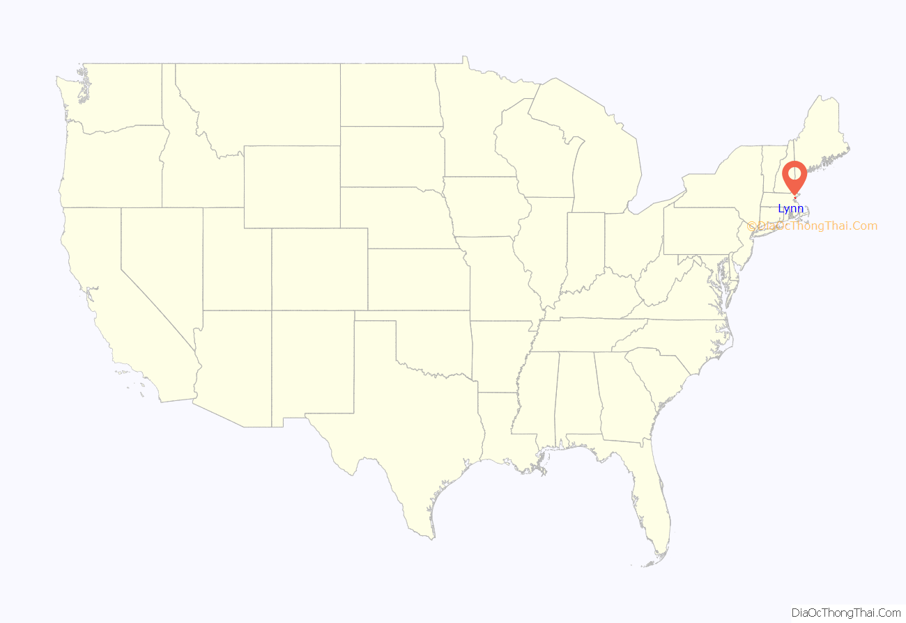
Lynn location map. Where is Lynn city?
History
Pre-contact
The area that is now known as Lynn was inhabited for thousands of years by Native Americans prior to English colonization in the 1600s. At the time of European contact, the area today known as Lynn was primarily inhabited by the Naumkeag people under the powerful sachem Nanepashemet who controlled territory from the Mystic to the Merrimack Rivers. Colonists would not establish a legal agreement with the Naumkeag over the use of their land in Lynn until 1686 after a smallpox epidemic in 1633, King Philip’s War, and missionary efforts significantly reduced their numbers and confined them to the Praying Town of Natick.
17th century
English colonists settled Lynn not long after the 1607 establishment of Jamestown, Virginia and the 1620 arrival of the Mayflower at Plymouth. European settlement of the area was begun in 1629 by Edmund Ingalls, followed by John Tarbox of Lancashire in 1631. The area today encompassing Lynn was originally incorporated in 1629 as Saugus, the Massachusett name for the area. Three years after the settlement in Salem, five families moved onto Naumkeag lands in the interior of Lynn, then known as Saugus, and the Tomlin family constructed a large mill between today’s Sluice and Flax Ponds. The mill not only supplied grains and sustenance for the settlers and trade with the Naumkeag people, but was used to create brews and many fermented casks of hops and wines to send back to King George in England.
Lynn takes its name from King’s Lynn, Norfolk, England, in honor of Reverend Samuel Whiting (Senior), Lynn’s first official minister who arrived from King’s Lynn in 1637.
A noteworthy early Lynn colonist, Thomas Halsey, left Lynn to settle the East End of Long Island, where he and several others founded the Town of Southampton, New York. The resulting Halsey House—the oldest extant frame house in New York State (1648)—is now open to the public, under the aegis of the Southampton Colonial Society.
As English settlement pushed deeper into Naumkeag territories, disease, missionary efforts, and loss of access to seasonal hunting, farming, and fishing grounds caused significant disruption to Naumkeag lifeways. In 1675, Naumkeag sachem Wenepoykin joined Metacomet in resisting English colonization in King Philip’s War, for which he was enslaved and sent to Barbados. In 1686, under pressure to demonstrate legal title for lands they occupied during the administrative restructuring of the Dominion of New England, the selectmen of Lynn and Reading purchased a deed from Wenopoykin’s heirs Kunkshamooshaw and Quonopohit for 16 pounds of sterling silver, though by this time they and most surviving Naumkeag were residents of the Natick Praying Town.
Further European settlement of Lynn led to several independent towns being formed, with Reading created in 1644; Lynnfield in 1782; Saugus in 1815; Swampscott in 1852; and Nahant in 1853. The City of Lynn was incorporated on May 14, 1850.
Colonial Lynn was an early center of tannery and shoe-making, which began in 1635. The boots worn by Continental Army soldiers during the Revolutionary War were made in Lynn, and the shoe-making industry drove the city’s growth into the early nineteenth century. This legacy is reflected in the city’s seal, which features a colonial boot.
19th century
In 1816, a mail stage coach was operating through Lynn. By 1836, 23 stage coaches left the Lynn Hotel for Boston each day. The Eastern Railroad Line between Salem and East Boston opened on August 28, 1838. This was later merged with the Boston and Maine Railroad and called the Eastern Division. In 1847 telegraph wires passed through Lynn, but no telegraph service station was built until 1858.
During the middle of the nineteenth century, estates and beach cottages were constructed along Lynn’s shoreline, and the city’s Atlantic coastline became a fashionable summer resort. Many of the structures built during this period are today situated within the National Register-listed Diamond Historic District.
Further inland, industrial activity contemporaneously expanded in Lynn. Shoe manufacturers, led by Charles A. Coffin and Silas Abbott Barton, invested in the early electric industry, specifically in 1883 with Elihu Thomson, Edwin J. Houston, and their Thomson-Houston Electric Company. That company merged with Edison Electric Company of Schenectady, New York, forming General Electric in 1892, with the two original GE plants being in Lynn and Schenectady. Coffin served as the first president of General Electric.
Initially the General Electric plant specialized in arc lights, electric motors, and meters. Later it specialized in aircraft electrical systems and components, and aircraft engines were built in Lynn during WWII. That engine plant evolved into the current jet engine plant during WWII because of research contacts at MIT in Cambridge. Gerhard Neumann was a key player in jet engine group at GE in Lynn. The continuous interaction of material science research at MIT and the resulting improvements in jet engine efficiency and power have kept the jet engine plant in Lynn ever since.
One of the largest strikes of the early labor movement began in the shoe factories of Lynn on February 22, 1860, when Lynn shoemakers marched through the streets to their workplaces and handed in their tools, protesting reduced wages. Known as the New England Shoemakers Strike of 1860, it was one of the earliest strikes of its kind in the United States.
In 1841, abolitionist Frederick Douglass, moved to Lynn as a fugitive slave. Douglass wrote his first autobiography, Narrative of the Life of Frederick Douglass, an American Slave, while living in Lynn. The publication would become Douglass’s best-known work. Douglass, his wife, and their five children lived in Lynn until 1848.
On February 1, 1866, Mary Baker Eddy experienced the “fall in Lynn”, often referred to by Christian Scientists as significant to the birth of their religion.
In 1889 a massive fire swept through the downtown of Lynn, and would not be matched in size until nearly 100 years later. At the time the loss was the third largest from fire in New England history. A total of 296 building were destroyed, including 142 homes, 25 stores, the Central Square railroad depot, four banks and four newspaper buildings. It was estimated that 200 families were made homeless and 10,000 jobs were lost. Estimates put the total loss as high as $6,000,000 (equivalent to about $180,960,000 in 2021).
20th century
Lynn experienced a wave of immigration during the late 1800s and early 1900s. During the 30 years between 1885 and 1915, Lynn’s immigrant population increased from 9,800 to 29,500, representing nearly one-third of the city’s total population. Polish and Russian Jews were the largest single group, numbering more than 6,000. The first Jewish settlers in Lynn, a group of twenty Hasidic European families, mostly from Russia, formed the Congregation Anshai Sfard, a Hasidic, conservative Jewish synagogue in 1888.
Catholic churches catering to the needs of specific language and ethnic groups also testify to the waves of immigrants. St. Jean Baptiste parish, eventually including a grammar school and high school, was founded in 1886, primarily for French-Canadians. Holy Family Church conducted services in Italian beginning in 1922, and St. Michael’s church also provided church services and a grammar school for the Polish-speaking community, beginning in 1906. St. Patrick’s church and school was a focus of the Irish-American community in Lynn. St. George’s Greek Orthodox Church was founded in Lynn in 1905. Later in the 20th century, the city became an important center of greater Boston’s Latino community. Additionally, several thousand Cambodians settled in Lynn between 1975 and 1979 and in the early 1980s.
At the beginning of the 20th century, Lynn was the world-leader in the production of shoes. 234 factories produced more than a million pairs of shoes each day, thanks in part to mechanization of the process by an African-American immigrant named Jan Ernst Matzeliger. From 1924 until 1974, the Lynn Independent Industrial Shoemaking School operated in the city. However, production declined throughout the 20th century, and the last shoe factory closed in 1981.
In the early 1900s, the Metropolitan District Commission acquired several coastal properties in Lynn and Nahant, in order to create Lynn Shore and Nahant Beach Reservations, and to construct adjoining Lynn Shore Drive. When it opened to the public in 1910, Lynn Shore Drive catalyzed new development along Lynn’s coastline, yielding many of the early 20th century structures that constitute a majority of the contributing resources found in the National Register-listed Diamond Historic District.
During the late 1970s and early 1980s, Lynn suffered several large fires. On November 28, 1981, a devastating inferno engulfed several former shoe factories, located at Broad and Washington Streets. Seventeen downtown buildings were destroyed in less than twelve hours, with property losses estimated to be totaling at least $35,000,000 (equivalent to about $104,320,000 in 2021). At least 18 businesses were affected, resulting in the estimated loss of 1,500 jobs. The Lynn campus of the North Shore Community College, planning for which was already underway at the time of the fire, now occupies much of the burned area.
A reputation for crime and vice gave rise to a taunting rhyme about Lynn which became popular throughout Eastern Massachusetts: “Lynn, Lynn, the city of sin, you’ll never come out the way you went in, what looks like gold is really tin, the girls say ‘no’ but they’ll give in, Lynn, Lynn, the city of sin.” Another variation was “Lynn, Lynn the city of sin: if you ain’t bad, you can’t get in!”
In order to counter its reputation as “the city of sin”, Lynn launched a “City Of Firsts” advertising campaign in the early 1990s, which promoted Lynn as having:
- First iron works (1643)
- First fire engine (1654)
- First electric streetcar to operate in Massachusetts (November 19, 1888)
- First American jet engine
- First woman in advertising & mass-marketing – Lydia Pinkham
- First baseball game under artificial light
- First dance academy in the U.S.
- First tannery in the U.S.
- First air mail transport in New England, from Saugus, MA to Lynn, MA
- First roast beef sandwich
- First tulip in the United States, at the Fay Estate near Spring Pond
Some of these claims were subsequently found to be inaccurate or unprovable.
In a further effort to rebrand the municipality, city solicitor Michael Barry proposed renaming the city Ocean Park in 1997, but the initiative was unsuccessful.
Despite losing much of its industrial base during the 20th century, Lynn remained home to many companies, such as:
- A division of General Electric Aviation, focused on manufacturing jet engines
- West Lynn Creamery (now part of Dean Foods’s Garelick Farms unit)
- C. L. Hauthaway & Sons, a polymer producer
- Old Neighborhood Foods, a meat packer
- Lynn Manufacturing, a maker of combustion chambers for the oil and gas heating industry
- Sterling Machine Co.
- Durkee-Mower, makers of “Marshmallow Fluff”
21st century
In the early 2000s, the renovation and adaptive re-use of downtown historic structures, together with new construction, launched a revitalization of Lynn, which remains ongoing. Arts, culture, and entertainment have been at the forefront of this revitalization, with new arts organizations, cultural venues, public art projects, and restaurants emerging in the downtown area. In 2012, the Massachusetts Cultural Council named downtown Lynn one of the first state-recognized arts and culture districts in Massachusetts.
In 2015, Massachusetts Governor Charlie Baker established a task force, composed of representatives of multiple state and municipal public agencies, to further Lynn’s revitalization.
Formerly vacant industrial buildings continue to be converted into loft spaces, and historic homes, particularly Lynn’s Diamond Historic District, are being restored. In 2016, several large land parcels in Lynn were acquired by major developers. In November 2018, construction began on downtown Lynn’s first luxury midrise—a 259-unit, 10-story building on Monroe Street. in December 2019, ground was broken on a 331-unit waterfront development on Carroll Parkway. Many of the recent and pending large real estate projects in Lynn are Transit-oriented developments, sited within a half-mile of Lynn station, which provides 20-minute train service to North Station.
Lynn’s revitalization has been bolstered by the city’s emergence as a center of creative placemaking.
In 2017, swaths of the city’s downtown were transformed by a series of large-scale murals, painted on buildings by local, national, and international artists, as part of the city’s inaugural Beyond Walls festival. Light-based interventions, including projections onto High Rock Tower, the installation of vintage neon signs on downtown buildings, and large-scale LED-illuminations of the Massachusetts Bay Transportation Authority rail underpasses bisecting Lynn’s Downtown, also have been deployed. In 2017, Mount Vernon Street, in the core of the downtown Central Square area, began to host block parties, food trucks, and other special events.
In recent years, Lynn has attracted a substantial and growing LGBT population.
In April 2018, The Boston Globe named Lynn one of the “Top spots to live in Greater Boston in 2018.”
On August 18, 2021, the new Frederick Douglass Park on Exchange Street was dedicated, directly across the street from the site of the Central Square railroad depot where Douglass was forcibly removed from the train in 1841. The park features a bronze bas-relief sculpture of Douglass. The park had been in the works since at least 2019 when a bill was filed in the Massachusetts Senate to designate the park area and its management by the Massachusetts DCR.
On September 16, 2021, Mayor McGee introduced Vision Lynn, a 20-year comprehensive planning project to expand Lynn’s diversity and improve infrastructure further. In the following year and a half, Lynn’s Planning Department held many opportunities for Lynners to discuss what they see for the future of the city. On April 10, 2023, a draft of the plan was shared on the planning departments website to allow for greater public comment. After May 15, 2023, the public comment window will be closed and the committee will release a final draft to be endorsed and adopted by the city.
Lynn Road Map
Lynn city Satellite Map
Geography
According to the United States Census Bureau, the city has a total area of 13.5 square miles (35 km), of which 10.8 square miles (28 km) is land and 2.7 square miles (7.0 km) (19.87%) is water. Lynn is located beside Massachusetts Bay and the Atlantic Ocean. Lynn’s shoreline is divided in half by the town of Nahant, which divides Lynn Harbor to the south from Nahant Bay to the north. The city lies north of the Saugus River, and is also home to several brooks, as well as several ponds, the largest being Breed’s Pond and Walden Pond (which has no relation to a similarly named pond in Concord). More than one-quarter of the town’s land is covered by the Lynn Woods Reservation, which takes up much of the land in the northwestern part of the city. The city is also home to two beaches, Lynn Beach and King’s Beach, both of which lie along Nahant Bay, as well as a boat ramp in Lynn Harbor.
Lynn is located in the southern part of Essex County and is 10 miles (16 km) northeast of Boston and 22 miles (35 km) west-southwest of Cape Ann. The city is bordered by Nahant to the southeast, Swampscott to the east, Salem to the northeast, Peabody to the north, Lynnfield to the northwest, Saugus to the west and Revere (in Suffolk County) to the south. Lynn’s water rights extend into Nahant Bay and share Lynn Harbor with Nahant. There is no land connection to Revere; the only connection is the General Edwards Bridge across the Pines River. Besides its downtown district, Lynn is also divided into East Lynn and West Lynn, which are further divided into even smaller areas.
Lynn is loosely segmented into the following neighborhoods:
Central:
- Downtown / Business District
- Central Square
West Lynn:
- Pine Hill
- McDonough Sq./ Barry Park
- Tower Hill / Austin Sq. – Saugus River
- The Commons
- The Brickyard
- Walnut St./Lynnhurst
- Veteran’s Village
East Lynn:
- Diamond District / Lynn Shore
- Wyoma Sq.
- The Highlands
- The Fay Estates
- Ward 1 / Lynnfield St.
- Goldfish Pond
- The Meadow / Keaney Park
Climate
Lynn gets cold, snowy winters and warm, humid summers. The climate is similar to that of Boston.
According to the Köppen climate classification, Lynn has either a hot-summer humid continental climate (abbreviated Dfa), or a hot-summer humid sub-tropical climate (abbreviated Cfa), depending on the isotherm used.
See also
Map of Massachusetts State and its subdivision: Map of other states:- Alabama
- Alaska
- Arizona
- Arkansas
- California
- Colorado
- Connecticut
- Delaware
- District of Columbia
- Florida
- Georgia
- Hawaii
- Idaho
- Illinois
- Indiana
- Iowa
- Kansas
- Kentucky
- Louisiana
- Maine
- Maryland
- Massachusetts
- Michigan
- Minnesota
- Mississippi
- Missouri
- Montana
- Nebraska
- Nevada
- New Hampshire
- New Jersey
- New Mexico
- New York
- North Carolina
- North Dakota
- Ohio
- Oklahoma
- Oregon
- Pennsylvania
- Rhode Island
- South Carolina
- South Dakota
- Tennessee
- Texas
- Utah
- Vermont
- Virginia
- Washington
- West Virginia
- Wisconsin
- Wyoming
