Map of Townsend CDP, Massachusetts
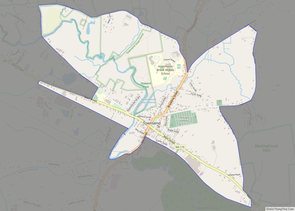
Townsend is a census-designated place (CDP) in the town of Townsend in Middlesex County, Massachusetts, United States. The population was 1,128 at the 2010 census. Townsend CDP overview: Name: Townsend CDP LSAD Code: 57 LSAD Description: CDP (suffix) State: Massachusetts County: Middlesex County Elevation: 315 ft (96 m) Total Area: 1.72 sq mi (4.47 km²) Land Area: 1.69 sq mi (4.39 km²) Water ... Read more
Map of Townsend CDP, Massachusetts
Map of Walpole CDP, Massachusetts
Walpole is a small census-designated place (CDP) located within the much larger town (21 square miles in size) of Walpole in Norfolk County, Massachusetts, United States. Walpole Town as it is called by the US Census Bureau, also includes a much larger population (24,070 in 2010). The population of the Census Designated Place was 5,918 ... Read more
Map of Walpole CDP, Massachusetts
Map of Wakefield CDP, Massachusetts
Wakefield is a town in Middlesex County, Massachusetts, in the Greater Boston metropolitan area, incorporated in 1812 and located about 12.5 mi (20.1 km) north-northwest of Downtown Boston. Wakefield’s population was 27,090 at the 2020 census. Wakefield offers an assortment of activities around the local lake, Lake Quannapowitt. Wakefield CDP overview: Name: Wakefield CDP LSAD Code: 57 ... Read more
Map of Wakefield CDP, Massachusetts
Map of Vineyard Haven CDP
Vineyard Haven is a community within the town of Tisbury, Massachusetts on the island of Martha’s Vineyard. It is listed as a census-designated place (CDP) by the U.S. Census Bureau with a population of 2,114 as of the 2010 census. The area was called “Nobnocket” by the Wampanoag people and was first referred to by ... Read more
Map of Vineyard Haven CDP
Map of Wareham Center CDP
Wareham Center is a census-designated place (CDP) in the town of Wareham in Plymouth County, Massachusetts, United States. The population was 2,896 at the 2010 census. Wareham Center CDP overview: Name: Wareham Center CDP LSAD Code: 57 LSAD Description: CDP (suffix) State: Massachusetts County: Plymouth County Elevation: 36 ft (11 m) Total Area: 2.15 sq mi (5.56 km²) Land Area: ... Read more
Map of Wareham Center CDP
Map of Ware CDP
Ware is a census-designated place (CDP) comprising the main village in the town of Ware in Hampshire County, Massachusetts, United States. The population of the CDP was 6,170 at the 2010 census, out of a total town population of 9,872. It is part of the Springfield, Massachusetts Metropolitan Statistical Area. Ware CDP overview: Name: Ware ... Read more
Map of Ware CDP
Map of Waltham city, Massachusetts
Waltham (/ˈwɔːlθæm/ WAWL-tham) is a city in Middlesex County, Massachusetts, United States, and was an early center for the labor movement as well as a major contributor to the American Industrial Revolution. The original home of the Boston Manufacturing Company, the city was a prototype for 19th century industrial city planning, spawning what became known ... Read more
Map of Waltham city, Massachusetts
Map of Watertown Town city
Watertown Town city overview: Name: Watertown Town city LSAD Code: 25 LSAD Description: city (suffix) State: Massachusetts County: Middlesex County FIPS code: 2573440 Online Interactive Map Watertown Town online map. Source: Basemap layers from Google Map, Open Street Map (OSM), Arcgisonline, Wmflabs. Boundary Data from Database of Global Administrative Areas. Watertown Town location map. Where ... Read more
Map of Watertown Town city
Map of Warren CDP, Massachusetts
Warren is a census-designated place (CDP) in the town of Warren in Worcester County, Massachusetts, United States. The population was 1,405 at the 2010 census. Warren CDP overview: Name: Warren CDP LSAD Code: 57 LSAD Description: CDP (suffix) State: Massachusetts County: Worcester County Elevation: 633 ft (193 m) Total Area: 1.30 sq mi (3.36 km²) Land Area: 1.28 sq mi (3.33 km²) Water ... Read more
Map of Warren CDP, Massachusetts
Map of Webster CDP, Massachusetts
Webster is a census-designated place (CDP) in the town of Webster in Worcester County, Massachusetts, United States. The population was 11,412 at the 2010 census. Webster CDP overview: Name: Webster CDP LSAD Code: 57 LSAD Description: CDP (suffix) State: Massachusetts County: Worcester County Elevation: 463 ft (141 m) Total Area: 3.03 sq mi (7.84 km²) Land Area: 2.97 sq mi (7.69 km²) Water ... Read more
Map of Webster CDP, Massachusetts
Map of West Chatham CDP
West Chatham is a census-designated place (CDP) in the town of Chatham in Barnstable County, Massachusetts, United States. The population was 1,410 at the 2010 census. West Chatham CDP overview: Name: West Chatham CDP LSAD Code: 57 LSAD Description: CDP (suffix) State: Massachusetts County: Barnstable County Elevation: 49 ft (15 m) Total Area: 3.32 sq mi (8.60 km²) Land Area: ... Read more
Map of West Chatham CDP
Map of West Brookfield CDP
West Brookfield is a census-designated place (CDP) in the town of West Brookfield in Worcester County, Massachusetts, United States. The population was 1,413 at the 2010 census. West Brookfield CDP overview: Name: West Brookfield CDP LSAD Code: 57 LSAD Description: CDP (suffix) State: Massachusetts County: Worcester County Elevation: 627 ft (191 m) Total Area: 1.77 sq mi (4.58 km²) Land ... Read more
Map of West Brookfield CDP