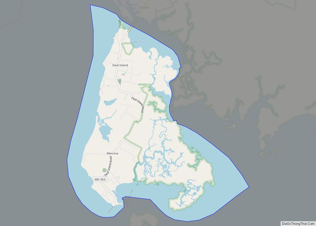
Deal Island is a census-designated place (CDP) in Somerset County, Maryland, United States. The population was 375 at the 2020 census. It is included in the Salisbury, Maryland-Delaware Metropolitan Statistical Area. The small town was listed on the National Register of Historic Places as the Deal Island Historic District in 2006. Deal Island CDP overview: ... Read more
Map of US Cities and Places
Derwood is an unincorporated area and census-designated place in east-central Montgomery County, Maryland, United States. It lays just north of Rockville, southeast of Gaithersburg, southwest of Olney, and northwest of the greater Silver Spring area. Derwood was originally “Deer Park” and was then “Deer Wood” before getting its current name. The unincorporated area of Derwood ... Read more
Denton is a town in Caroline County, Maryland, United States. The population of Denton was 4,418 as of the 2010 United States Census, and it is the county seat of Caroline County. Denton town overview: Name: Denton town LSAD Code: 43 LSAD Description: town (suffix) State: Maryland County: Caroline County Founded: 1781 Incorporated: 1802 Elevation: ... Read more
Delmar is a town in Wicomico County, Maryland, United States. The population was 3,003 at the 2010 census. It is included in the Salisbury, Maryland-Delaware Metropolitan Statistical Area. When the population is added to Delmar, Delaware, the town’s total population is 4,600. Delmar town overview: Name: Delmar town LSAD Code: 43 LSAD Description: town (suffix) ... Read more
Downsville is an unincorporated community and census-designated place (CDP) in southwestern Washington County, Maryland, United States. Its population was 355 as of the 2010 census. It is located southeast of Williamsport on Maryland Route 63 and on Maryland Route 632, southwest of Hagerstown. It is officially included in the Hagerstown Metropolitan Area (Hagerstown-Martinsburg, MD-WV Metropolitan ... Read more
District Heights is an incorporated municipality in Prince George’s County, Maryland, United States, located near Maryland Route 4. Per the 2020 census, the population was 5,959. For more information, see the separate articles on Forestville and Suitland. District Heights is located 9.85 miles (15.85 km) from central Washington. District Heights city overview: Name: District Heights city ... Read more
Detmold is an unincorporated community and census-designated place (CDP) in Allegany County, Maryland, United States. As of the 2010 census it had a population of 71. Detmold is in western Allegany County along Maryland Route 36, which leads north 9 miles (14 km) to Frostburg and 7 miles (11 km) south to Westernport. The town is in ... Read more
Drum Point is a census-designated place (CDP) in southern Calvert County, Maryland, United States, at the confluence of the Patuxent River with Chesapeake Bay. As of the 2010 census, the CDP had a population of 2,731. Prior to 2010 it was part of the Chesapeake Ranch Estates-Drum Point CDP. Drum Point CDP overview: Name: Drum ... Read more
Dunkirk is a census-designated place (CDP) in Calvert County, Maryland, United States. The population was 2,521 at the 2010 census. Dunkirk CDP overview: Name: Dunkirk CDP LSAD Code: 57 LSAD Description: CDP (suffix) State: Maryland County: Calvert County Elevation: 121 ft (37 m) Total Area: 7.33 sq mi (19.00 km²) Land Area: 6.59 sq mi (17.06 km²) Water Area: 0.75 sq mi (1.94 km²) Total Population: ... Read more
Dundalk (/ˈdʌndɔːk/ DUN-dawk or /ˈdʌndɒk/ DUN-dok) is an unincorporated community and census-designated place in Baltimore County, Maryland, United States. The population was 67,796 at the 2020 census. In 1960 and 1970, Dundalk was the largest unincorporated community in Maryland. It was named after the town of Dundalk, Ireland. Dundalk is considered one of the first ... Read more
East New Market town overview: Name: East New Market town LSAD Code: 43 LSAD Description: town (suffix) State: Maryland County: Dorchester County Incorporated: 1832 Elevation: 39 ft (12 m) Total Area: 0.40 sq mi (1.04 km²) Land Area: 0.40 sq mi (1.04 km²) Water Area: 0.00 sq mi (0.00 km²) Total Population: 389 Population Density: 972.50/sq mi (375.68/km²) ZIP code: 21631 Area code: 410 FIPS code: 2424450 ... Read more
Eakles Mills (also known as Eakles Mill) is an unincorporated community and census-designated place in Washington County, Maryland, United States. Its population was 26 as of the 2020 census. Snively Farm was listed on the National Register of Historic Places in 1979. Eakles Mill CDP overview: Name: Eakles Mill CDP LSAD Code: 57 LSAD Description: ... Read more