Map of Eagle Lake CDP, Maine
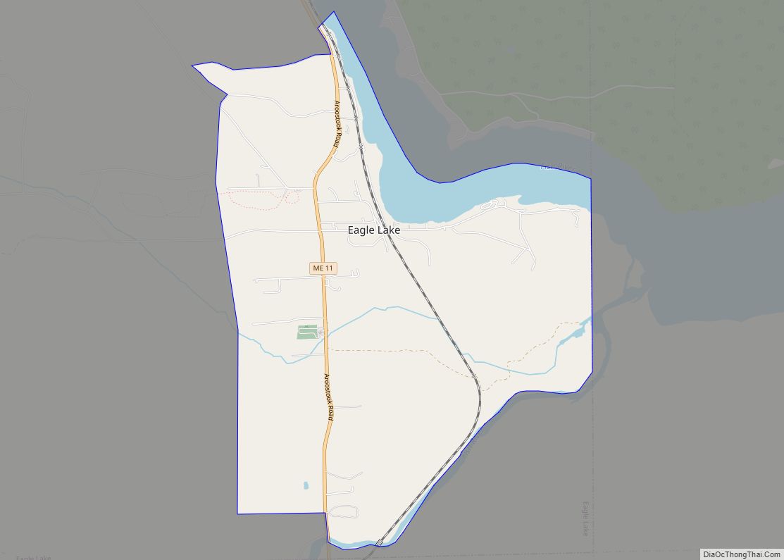
Eagle Lake is a town in Aroostook County, Maine, United States. The population was 772 at the 2020 census. The town was named by a body of troops heading from Bangor to the Aroostook War for the many eagles that they saw around the lake. A total of 49.0% of the population speaks French, reflecting ... Read more
Map of Eagle Lake CDP, Maine
Map of Falmouth Foreside CDP
Falmouth Foreside is a census-designated place (CDP) within the town of Falmouth in Cumberland County, Maine, in the United States. As of the 2010 census, the CDP population was 1,511. It is part of the Portland–South Portland–Biddeford, Maine Metropolitan Statistical Area. Falmouth Foreside CDP overview: Name: Falmouth Foreside CDP LSAD Code: 57 LSAD Description: CDP ... Read more
Map of Falmouth Foreside CDP
Map of Fairfield CDP, Maine
Fairfield is a census-designated place (CDP) in the town of Fairfield in Somerset County, Maine, United States. The population was 2,569 at the 2000 census. Fairfield CDP overview: Name: Fairfield CDP LSAD Code: 57 LSAD Description: CDP (suffix) State: Maine County: Somerset County Elevation: 141 ft (43 m) Total Area: 2.03 sq mi (5.26 km²) Land Area: 1.84 sq mi (4.76 km²) Water ... Read more
Map of Fairfield CDP, Maine
Map of Ellsworth city, Maine
Ellsworth is a city in and the county seat of Hancock County, Maine, United States. The 2020 Census determined it had a population of 8,399. Named after United States Founding Father Oliver Ellsworth, it contains historic buildings and other points of interest, and is close to Acadia National Park. Ellsworth city overview: Name: Ellsworth city ... Read more
Map of Ellsworth city, Maine
Map of Farmington CDP, Maine
Farmington is a census-designated place (CDP) comprising the center of the town of Farmington, which is the county seat of Franklin County in Maine, United States. The population of the CDP was 4,288 at the 2010 census, out of 7,760 people in the town as a whole. The University of Maine at Farmington is located ... Read more
Map of Farmington CDP, Maine
Map of Farmingdale CDP, Maine
Farmingdale is a census-designated place (CDP) in the town of Farmingdale in Kennebec County, Maine, United States. The population was 1,970 at the 2010 census, out of 2,956 in the entire town. Farmingdale CDP overview: Name: Farmingdale CDP LSAD Code: 57 LSAD Description: CDP (suffix) State: Maine County: Kennebec County Elevation: 52 ft (16 m) Total Area: ... Read more
Map of Farmingdale CDP, Maine
Map of Falmouth CDP, Maine
Falmouth is a census-designated place (CDP) within the town of Falmouth in Cumberland County, Maine, United States. The population was 1,855 at the 2010 census. It is part of the Portland–South Portland–Biddeford, Maine Metropolitan Statistical Area. Falmouth CDP overview: Name: Falmouth CDP LSAD Code: 57 LSAD Description: CDP (suffix) State: Maine County: Cumberland County Elevation: ... Read more
Map of Falmouth CDP, Maine
Map of Freeport CDP, Maine
Freeport is a census-designated place (CDP) in the town of Freeport in Cumberland County, Maine, United States. The population was 1,485 at the 2010 census. It is part of the Portland–South Portland–Biddeford, Maine Metropolitan Statistical Area. Freeport CDP overview: Name: Freeport CDP LSAD Code: 57 LSAD Description: CDP (suffix) State: Maine County: Cumberland County Elevation: ... Read more
Map of Freeport CDP, Maine
Map of Fort Kent CDP
Fort Kent is a census-designated place (CDP) that comprises the main village in the town of Fort Kent in Aroostook County, Maine, United States. In 2010, Fort Kent’s population was 2,488 of 4,097 for the entire town. Fort Kent CDP overview: Name: Fort Kent CDP LSAD Code: 57 LSAD Description: CDP (suffix) State: Maine County: ... Read more
Map of Fort Kent CDP
Map of Fort Fairfield CDP
Fort Fairfield is a census-designated place (CDP) comprising the main village within the town of Fort Fairfield in Aroostook County, Maine, United States. The population of the CDP was 1,825 at the 2010 census, out of a population of 3,496 for the entire town. Fort Fairfield is named for John Fairfield, 13th and 16th governor ... Read more
Map of Fort Fairfield CDP
Map of Gorham CDP, Maine
Gorham is a census-designated place (CDP) in the town of Gorham, in Cumberland County, Maine, United States. The population was 6,882 at the 2010 census. It is part of the Portland–South Portland–Biddeford, Maine Metropolitan Statistical Area. Gorham CDP overview: Name: Gorham CDP LSAD Code: 57 LSAD Description: CDP (suffix) State: Maine County: Cumberland County Elevation: ... Read more
Map of Gorham CDP, Maine
Map of Gardiner city, Maine
Gardiner is a city in Kennebec County, Maine, United States. The population was 5,961 at the 2020 census. Popular with tourists, Gardiner is noted for its culture and old architecture. Gardiner is a nationally accredited Main Street America community. It is included in the Augusta, Maine micropolitan New England City and Town Area. Gardiner city ... Read more
Map of Gardiner city, Maine