Map of Cape Neddick CDP
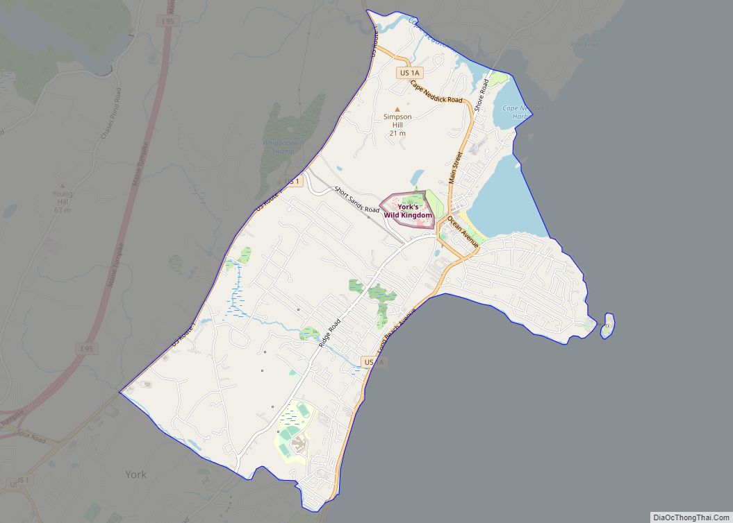
Cape Neddick is a census-designated place (CDP) in the town of York in York County, Maine, United States. The population was 2,568 at the 2010 census. It is part of the Portland–South Portland–Biddeford, Maine Metropolitan Statistical Area. Cape Neddick CDP overview: Name: Cape Neddick CDP LSAD Code: 57 LSAD Description: CDP (suffix) State: Maine County: ... Read more
Map of Cape Neddick CDP
Map of Clinton CDP, Maine
Clinton is a census-designated place (CDP) and the primary village in the town of Clinton in Kennebec County, Maine, United States. The population was 1,419 at the 2010 census, out of 3,486 in the entire town of Clinton. Clinton CDP overview: Name: Clinton CDP LSAD Code: 57 LSAD Description: CDP (suffix) State: Maine County: Kennebec ... Read more
Map of Clinton CDP, Maine
Map of Chisholm CDP, Maine
Chisholm is a census-designated place (CDP) in the town of Jay in Franklin County, Maine, United States. The population was 1,380 at the 2010 census. It is an industrial village named for Hugh J. Chisholm, who built the Otis Falls Pulp & Paper Company here in 1888 to use Androscoggin River water power. Chisholm CDP ... Read more
Map of Chisholm CDP, Maine
Map of Castine CDP, Maine
Castine is a census-designated place (CDP) in the town of Castine in Hancock County, Maine, United States. The CDP population was 1,029 at the 2010 census, out of 1,366 people in the town as a whole. Castine CDP overview: Name: Castine CDP LSAD Code: 57 LSAD Description: CDP (suffix) State: Maine County: Hancock County Elevation: ... Read more
Map of Castine CDP, Maine
Map of Damariscotta CDP
Damariscotta is a census-designated place (CDP) comprising the main village of the town of Damariscotta in Lincoln County, Maine, United States. The population was 1,142 at the 2010 census, out of 2,218 in the entire town. In the 2000 census, the village was part of the Damariscotta-Newcastle CDP. Damariscotta CDP overview: Name: Damariscotta CDP LSAD ... Read more
Map of Damariscotta CDP
Map of Cumberland Center CDP
Cumberland Center is a census-designated place (CDP) within the town of Cumberland in Cumberland County, Maine, United States. The population was 2,499 at the 2010 census. It is part of the Portland – South Portland – Biddeford, Maine, Metropolitan Statistical Area. Cumberland Center CDP overview: Name: Cumberland Center CDP LSAD Code: 57 LSAD Description: CDP ... Read more
Map of Cumberland Center CDP
Map of Cousins Island CDP
Cousins Island is an island in Casco Bay within the town of Yarmouth in Cumberland County, Maine, United States. It is listed as a census-designated place, with a population of 490 as of the 2010 census. The CDP is part of the Portland–South Portland–Biddeford, Maine Metropolitan Statistical Area. The island is connected to mainland Yarmouth ... Read more
Map of Cousins Island CDP
Map of Dover-Foxcroft CDP
Dover-Foxcroft is a census-designated place (CDP) in the town of Dover-Foxcroft in Piscataquis County, Maine, United States. The population was 2,592 at the 2000 census. Dover-Foxcroft CDP overview: Name: Dover-Foxcroft CDP LSAD Code: 57 LSAD Description: CDP (suffix) State: Maine County: Piscataquis County Elevation: 361 ft (110 m) Total Area: 8.61 sq mi (22.30 km²) Land Area: 8.38 sq mi (21.71 km²) Water ... Read more
Map of Dover-Foxcroft CDP
Map of Dixfield CDP
Dixfield is a census-designated place (CDP) in the town of Dixfield in Oxford County, Maine, United States. The population was 1,323 at the 2020 census. Dixfield CDP overview: Name: Dixfield CDP LSAD Code: 57 LSAD Description: CDP (suffix) State: Maine County: Oxford County Elevation: 436 ft (133 m) Total Area: 1.90 sq mi (4.91 km²) Land Area: 1.79 sq mi (4.64 km²) Water ... Read more
Map of Dixfield CDP
Map of Dexter CDP, Maine
Dexter is a census-designated place (CDP) comprising the main settlement within the town of Dexter in Penobscot County, Maine, United States. The population of the CDP was 2,158 at the 2010 census. Dexter CDP overview: Name: Dexter CDP LSAD Code: 57 LSAD Description: CDP (suffix) State: Maine County: Penobscot County Elevation: 417 ft (127 m) Total Area: ... Read more
Map of Dexter CDP, Maine
Map of Eastport city, Maine
Eastport is a city and archipelago in Washington County, Maine, United States. The population was 1,288 at the 2020 census, making Eastport the least-populous city in Maine. The principal island is Moose Island, which is connected to the mainland by a causeway. Eastport is the easternmost city in the continental United States (although the nearby ... Read more
Map of Eastport city, Maine
Map of East Millinocket CDP
East Millinocket is a census-designated place (CDP) consisting of the main settlement in the town of East Millinocket in Penobscot County, Maine, United States. The population was 1,567 at the 2010 census. East Millinocket CDP overview: Name: East Millinocket CDP LSAD Code: 57 LSAD Description: CDP (suffix) State: Maine County: Penobscot County Elevation: 367 ft (112 m) ... Read more
Map of East Millinocket CDP