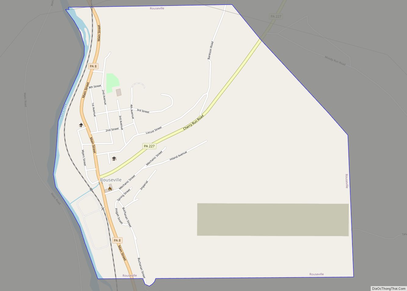
Roulette is a census-designated place located in Roulette Township in far western Potter County in the state of Pennsylvania, United States. It is located along the Allegheny River, approximately 20 miles southwest of the river’s source. The town is also on U.S. Route 6, roughly halfway between Port Allegany and Coudersport. As of the 2010 ... Read more
Pennsylvania Cities and Places
Rothsville is an unincorporated community and census-designated place (CDP) in Warwick Township, Lancaster County, Pennsylvania, United States. The population was 3,044 at the 2010 census. Lititz is the town for residents’ mailing addresses. Rothsville CDP overview: Name: Rothsville CDP LSAD Code: 57 LSAD Description: CDP (suffix) State: Pennsylvania County: Lancaster County Elevation: 490 ft (150 m) Total ... Read more
Rote is a census-designated place located in Lamar Township in southern Clinton County, Pennsylvania, United States. As of the 2010 census, the population was 507. Rote is located near the center of Lamar Township in southern Clinton County, along Pennsylvania Route 477 near the northeastern end of the Nittany Valley. PA 477 leads west 3 ... Read more
Rosslyn Farms is a suburban borough located 5 miles (8 km) west of Pittsburgh in Allegheny County, Pennsylvania, United States. It is a small community, with an area of only 0.6 square miles (1.6 km). The population was 441 at the 2020 census. Rosslyn Farms borough overview: Name: Rosslyn Farms borough LSAD Code: 21 LSAD Description: borough ... Read more
Rossiter is a Census-designated place (CDP) in Indiana County, Pennsylvania, United States. The population was 646 at the 2010 census. Rossiter CDP overview: Name: Rossiter CDP LSAD Code: 57 LSAD Description: CDP (suffix) State: Pennsylvania County: Indiana County Total Area: 1.9 sq mi (4.8 km²) Land Area: 1.9 sq mi (4.8 km²) Total Population: 646 Population Density: 350/sq mi (130/km²) FIPS code: ... Read more
Roseville is a borough in Tioga County, Pennsylvania, United States. The population was 177 at the 2020 census. Roseville borough overview: Name: Roseville borough LSAD Code: 21 LSAD Description: borough (suffix) State: Pennsylvania County: Tioga County Elevation: 1,342 ft (409 m) Total Area: 0.47 sq mi (1.23 km²) Land Area: 0.47 sq mi (1.23 km²) Water Area: 0.00 sq mi (0.00 km²) Total Population: 177 Population ... Read more
Rutherford is a census-designated place (CDP) in Swatara Township, Dauphin County, Pennsylvania, United States. The area is also known as Rutherford Heights. The population was 4,303 at the 2010 census, an increase over the figure of 3,859 tabulated in 2000. It is part of the Harrisburg–Carlisle Metropolitan Statistical Area. Rutherford CDP overview: Name: Rutherford CDP ... Read more
Russellton is a census-designated place (CDP) in Allegheny County, Pennsylvania, United States. The population was 1,330 at the 2020 census. Russellton CDP overview: Name: Russellton CDP LSAD Code: 57 LSAD Description: CDP (suffix) State: Pennsylvania County: Allegheny County Total Area: 1.4 sq mi (4 km²) Land Area: 1.4 sq mi (4 km²) Total Population: 1,330 Population Density: 950/sq mi (370/km²) FIPS code: ... Read more
Russell is an unincorporated community and census-designated place in Pine Grove Township, Warren County, Pennsylvania, United States. The community is east of Lander and lies at the intersection of U.S. Route 62 and Pennsylvania Route 957. It is drained by Conewango Creek. As of the 2010 census, the population was 1,408. Keystone marker Russell CDP ... Read more
Rural Valley is a borough in Armstrong County, Pennsylvania, United States. The population was 826 at the 2020 census. Rural Valley borough overview: Name: Rural Valley borough LSAD Code: 21 LSAD Description: borough (suffix) State: Pennsylvania County: Armstrong County Elevation: 1,120 ft (340 m) Total Area: 2.11 sq mi (5.47 km²) Land Area: 2.11 sq mi (5.47 km²) Water Area: 0.00 sq mi (0.00 km²) Total ... Read more
Rupert is a census-designated place (CDP) in Columbia County, Pennsylvania, United States. It is part of Northeastern Pennsylvania. The population was 183 at the 2010 census. It is part of the Bloomsburg-Berwick micropolitan area. Rupert CDP overview: Name: Rupert CDP LSAD Code: 57 LSAD Description: CDP (suffix) State: Pennsylvania County: Columbia County Elevation: 510 ft (160 m) ... Read more
Royersford is a borough in Montgomery County, Pennsylvania, United States, 32 miles (51 km) northwest of Philadelphia, on the Schuylkill River. Royersford borough overview: Name: Royersford borough LSAD Code: 21 LSAD Description: borough (suffix) State: Pennsylvania County: Montgomery County Incorporated: 1879 Elevation: 239 ft (73 m) Total Area: 0.82 sq mi (2.13 km²) Land Area: 0.79 sq mi (2.04 km²) Water Area: 0.03 sq mi (0.09 km²) ... Read more