Map of Trucksville CDP
Trucksville is a census-designated place (CDP) in Kingston Township, Luzerne County, Pennsylvania, United States. The population was 2,152 at the 2010 census. Trucksville CDP overview: Name: Trucksville CDP LSAD Code: 57 LSAD Description: CDP (suffix) State: Pennsylvania County: Luzerne County Total Area: 1.7 sq mi (4.5 km²) Land Area: 1.7 sq mi (4.5 km²) Water Area: 0 sq mi (0 km²) Total Population: 2,152 ... Read more
Map of Trucksville CDP
Map of Troy borough, Pennsylvania
Troy is a borough in Bradford County, Pennsylvania, United States. It is part of Northeastern Pennsylvania. The population was 1,354 at the 2010 census. Children residing in the borough are assigned to attend the Troy Area School District. Troy borough overview: Name: Troy borough LSAD Code: 21 LSAD Description: borough (suffix) State: Pennsylvania County: Bradford ... Read more
Map of Troy borough, Pennsylvania
Map of Twilight borough, Pennsylvania
Twilight borough overview: Name: Twilight borough LSAD Code: 21 LSAD Description: borough (suffix) State: Pennsylvania County: Washington County FIPS code: 4278008 Online Interactive Map Twilight online map. Source: Basemap layers from Google Map, Open Street Map (OSM), Arcgisonline, Wmflabs. Boundary Data from Database of Global Administrative Areas. Twilight location map. Where is Twilight borough? Twilight ... Read more
Map of Twilight borough, Pennsylvania
Map of Tuscarora CDP, Pennsylvania
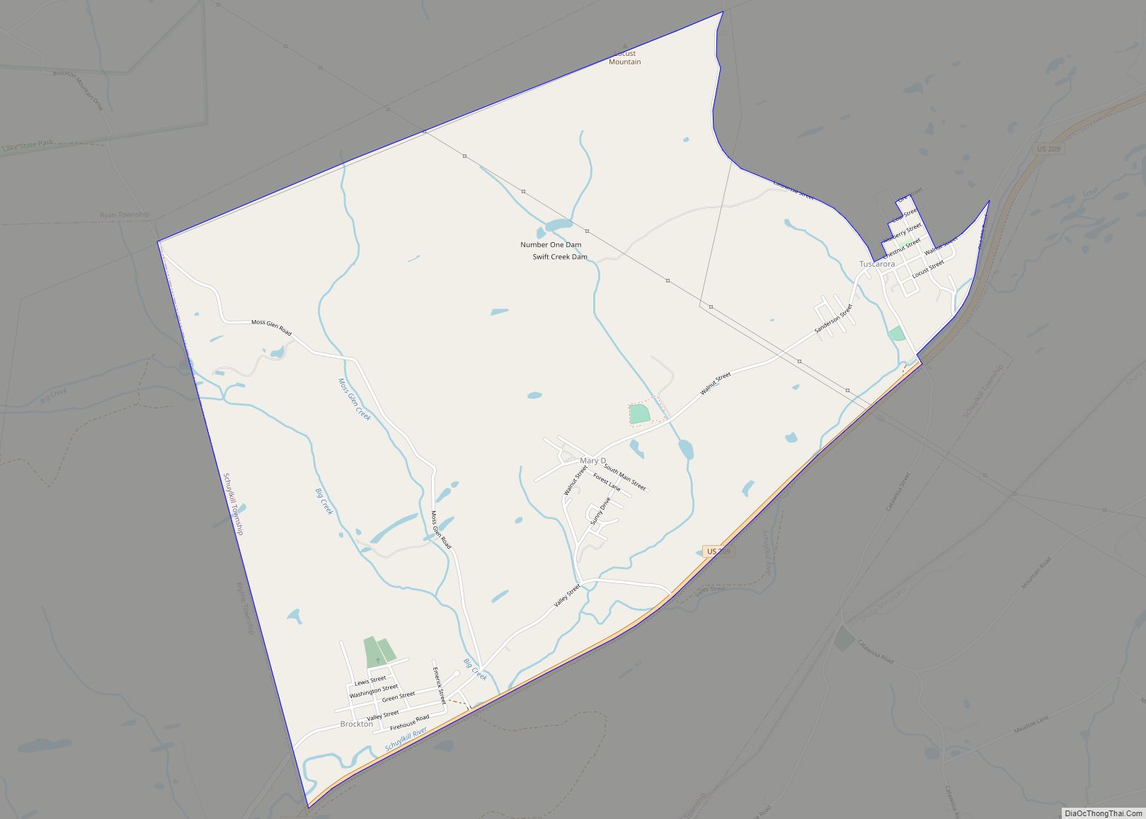
Tuscarora is a census-designated place (CDP) in Schuylkill County, Pennsylvania, United States. The population was 980 at the 2010 census. Tuscarora CDP overview: Name: Tuscarora CDP LSAD Code: 57 LSAD Description: CDP (suffix) State: Pennsylvania County: Schuylkill County Total Area: 3.6 sq mi (9.3 km²) Land Area: 3.6 sq mi (9.3 km²) Total Population: 980 Population Density: 270/sq mi (110/km²) ZIP code: ... Read more
Map of Tuscarora CDP, Pennsylvania
Map of University of Pittsburgh Johnstown CDP
University of Pittsburgh Johnstown CDP overview: Name: University of Pittsburgh Johnstown CDP LSAD Code: 57 LSAD Description: CDP (suffix) State: Pennsylvania County: Cambria County FIPS code: 4278700 Online Interactive Map University of Pittsburgh Johnstown online map. Source: Basemap layers from Google Map, Open Street Map (OSM), Arcgisonline, Wmflabs. Boundary Data from Database of Global Administrative ... Read more
Map of University of Pittsburgh Johnstown CDP
Map of Unionville CDP, Pennsylvania
Unionville is a census-designated place located in Center Township, Butler County, in the U.S. state of Pennsylvania. As of the 2010 census, the population was 962. Unionville is located in the northwestern corner of Center Township and is bordered to the southwest by the Shanor-Northvue CDP, to the north by Clay Township and to the ... Read more
Map of Unionville CDP, Pennsylvania
Map of Uniontown city, Pennsylvania
Uniontown is the largest city in and county seat of Fayette County, Pennsylvania, United States, 46 miles (74 km) southeast of Pittsburgh. The population was 9,984 at the 2020 census. It is part of the Pittsburgh metropolitan area. Uniontown city overview: Name: Uniontown city LSAD Code: 25 LSAD Description: city (suffix) State: Pennsylvania County: Fayette County ... Read more
Map of Uniontown city, Pennsylvania
Map of Union Deposit CDP
Union Deposit is an unincorporated community and census-designated place in South Hanover Township, Dauphin County, Pennsylvania, United States. It is part of the Harrisburg–Carlisle Metropolitan Statistical Area. As of the 2010 census the population of Union Deposit was 407 residents. Union Deposit (formerly called Unionville and Uniontown) was laid out in 1833 by Isaac Hershey ... Read more
Map of Union Deposit CDP
Map of Union Dale borough
Union Dale is a borough in Susquehanna County, Pennsylvania, United States. The borough was incorporated in 1885. Union Dale’s population was 267 at the 2010 census. Union Dale borough overview: Name: Union Dale borough LSAD Code: 21 LSAD Description: borough (suffix) State: Pennsylvania County: Susquehanna County Incorporated: 1885 Total Area: 2.47 sq mi (6.39 km²) Land Area: 2.41 sq mi ... Read more
Map of Union Dale borough
Map of Union City borough, Pennsylvania
Union City is a borough in Erie County, Pennsylvania, United States. It is located 22 miles (35 km) southeast of Erie. In the twentieth century, there were three large chair factories, planing and grist mills, a powdered milk plant, and several furniture factories. The population was 2,934 at the 2020 census. Nearly 96.69% of the town ... Read more
Map of Union City borough, Pennsylvania
Map of Ulysses borough, Pennsylvania
Ulysses is a borough in Potter County, Pennsylvania, United States. The population was 600 at the 2020 census. The borough is located in a rural farming and forested area in north central Pennsylvania, which is known as the Pennsylvania Wilds.   It also stands in the middle of the Triple Continental Divide. In 2019 the ... Read more
Map of Ulysses borough, Pennsylvania
Map of Tyrone borough, Pennsylvania
Tyrone is a borough in Blair County, Pennsylvania, United States, located 15 miles (24 km) northeast of Altoona, on the Little Juniata River. Tyrone was of considerable commercial importance in the twentieth century. It was an outlet for the Clearfield coal fields and was noted for manufacturing paper products. There were planing mills and chemical and ... Read more
Map of Tyrone borough, Pennsylvania