Map of Boiling Springs CDP, Pennsylvania
Boiling Springs is a census-designated place (CDP) in South Middleton Township, Cumberland County, Pennsylvania and is part of the Harrisburg–Carlisle metropolitan statistical area. The population was 3,225 at the 2010 census, up from 2,769 at the 2000 census. Boiling Springs CDP overview: Name: Boiling Springs CDP LSAD Code: 57 LSAD Description: CDP (suffix) State: Pennsylvania ... Read more
Map of Boiling Springs CDP, Pennsylvania
Map of Boyertown borough
Boyertown (Pennsylvania Dutch: Boyerschteddel) is a borough in Berks County, Pennsylvania. The population was 4,055 at the 2010 census. Boyertown is known for the many painted fiberglass bears that can be found throughout the town and borough. Boyertown borough overview: Name: Boyertown borough LSAD Code: 21 LSAD Description: borough (suffix) State: Pennsylvania County: Berks County ... Read more
Map of Boyertown borough
Map of Bowmansville CDP
Bowmansville is an unincorporated community and census-designated place (CDP) in Brecknock Township, Lancaster County, Pennsylvania, United States. Bowmansville is home to a Pennsylvania Turnpike service plaza. The population was 2,077 as of the 2010 census. Bowmansville CDP overview: Name: Bowmansville CDP LSAD Code: 57 LSAD Description: CDP (suffix) State: Pennsylvania County: Lancaster County Founded: 1820 ... Read more
Map of Bowmansville CDP
Map of Bowmanstown borough
Bowmanstown is a borough in Carbon County, Pennsylvania. It is part of Northeastern Pennsylvania. The population was 937 at the 2010 census. The borough is at an elevation of 437 feet (133 m). It is located 3 miles (5 km) west of Palmerton and 4 miles (6 km) south of Lehighton off Pennsylvania Route 248. Bowmanstown borough overview: ... Read more
Map of Bowmanstown borough
Map of Bowers CDP, Pennsylvania
Bowers is a census-designated place in Maxatawny Township, Berks County, Pennsylvania, United States. It is located near the borough of Lyons and is on Sacony Creek, a tributary of the Maiden Creek. As of the 2010 census, the population was 326 residents. Although Bowers has its own post office with the ZIP code of 19511, ... Read more
Map of Bowers CDP, Pennsylvania
Map of Boswell borough, Pennsylvania
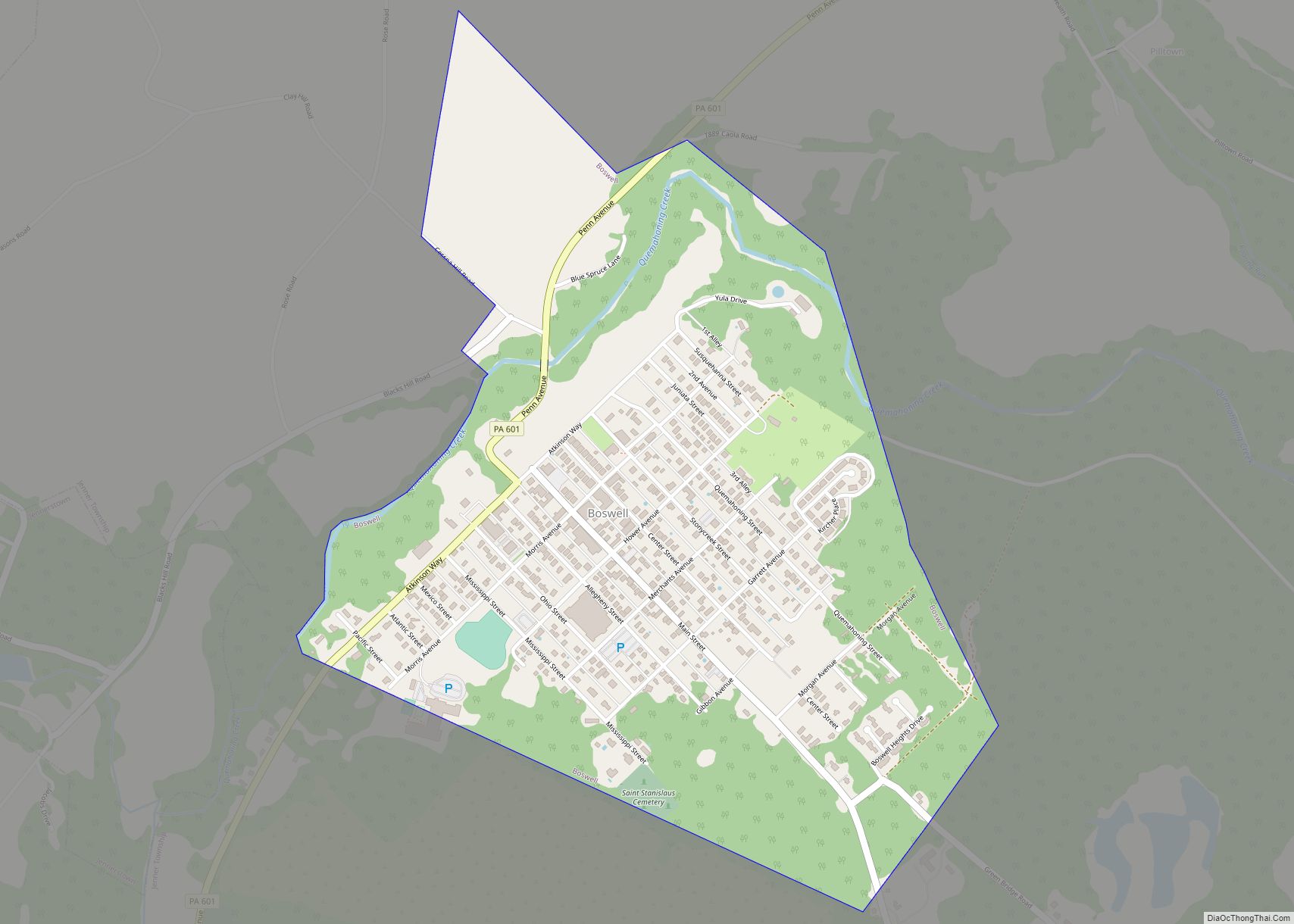
Boswell is a borough in Somerset County, Pennsylvania, United States. It is part of the Johnstown, Pennsylvania Metropolitan Statistical Area. The population was 1,221 at the 2020 census. Boswell borough overview: Name: Boswell borough LSAD Code: 21 LSAD Description: borough (suffix) State: Pennsylvania County: Somerset County Incorporated: February 22, 1904 Total Area: 0.74 sq mi (1.91 km²) Land ... Read more
Map of Boswell borough, Pennsylvania
Map of Breinigsville CDP
Breinigsville is an unincorporated community and census-designated place (CDP) in Lehigh County, Pennsylvania. As of the 2020 census, it had a population of 7,495. The town is part of Upper Macungie Township and is located approximately 11 miles (18 km) southwest of downtown Allentown and 8 miles (13 km) east of Kutztown. It is part of the ... Read more
Map of Breinigsville CDP
Map of Brave CDP
Brave is an unincorporated community and census-designated place (CDP) in Wayne Township, Greene County, Pennsylvania, United States. It lies in Pennsylvania’s southwestern corner near the West Virginia border. As of the 2010 census the population was 201. Brave CDP overview: Name: Brave CDP LSAD Code: 57 LSAD Description: CDP (suffix) State: Pennsylvania County: Greene County ... Read more
Map of Brave CDP
Map of Brandonville CDP, Pennsylvania
Brandonville is a census-designated place (CDP) in East Union Township, Schuylkill County, Pennsylvania, United States. The population was 217 at the 2000 census. Brandonville CDP overview: Name: Brandonville CDP LSAD Code: 57 LSAD Description: CDP (suffix) State: Pennsylvania County: Schuylkill County Total Area: 1.40 sq mi (3.63 km²) Land Area: 1.40 sq mi (3.63 km²) Water Area: 0.00 sq mi (0.00 km²) Total Population: ... Read more
Map of Brandonville CDP, Pennsylvania
Map of Branchdale CDP
Branchdale is a census-designated place (CDP) in Schuylkill County, Pennsylvania, United States. The population was 436 at the 2000 census. Branchdale CDP overview: Name: Branchdale CDP LSAD Code: 57 LSAD Description: CDP (suffix) State: Pennsylvania County: Schuylkill County Total Area: 0.71 sq mi (1.85 km²) Land Area: 0.71 sq mi (1.85 km²) Water Area: 0.00 sq mi (0.00 km²) Total Population: 328 Population Density: ... Read more
Map of Branchdale CDP
Map of Bradford city, Pennsylvania
Bradford is a city in McKean County, Pennsylvania. It is located close to the border with New York state and approximately 78 miles (126 km) south of Buffalo, New York. Home to an oil refinery, Zippo headquarters and a University of Pittsburgh branch campus, Bradford is the principal city in the Bradford, PA Micropolitan Statistical Area. ... Read more
Map of Bradford city, Pennsylvania
Map of Bradford Woods borough
Bradford Woods is a borough in Allegheny County, Pennsylvania, United States. The population was 1,183 at the 2020 census. A suburb of the Pittsburgh metropolitan area, it is part of the North Allegheny School District and participates in the multi-municipality Northland Public Library. It is home to Bradford Woods Elementary School. Bradford Woods borough overview: ... Read more
Map of Bradford Woods borough