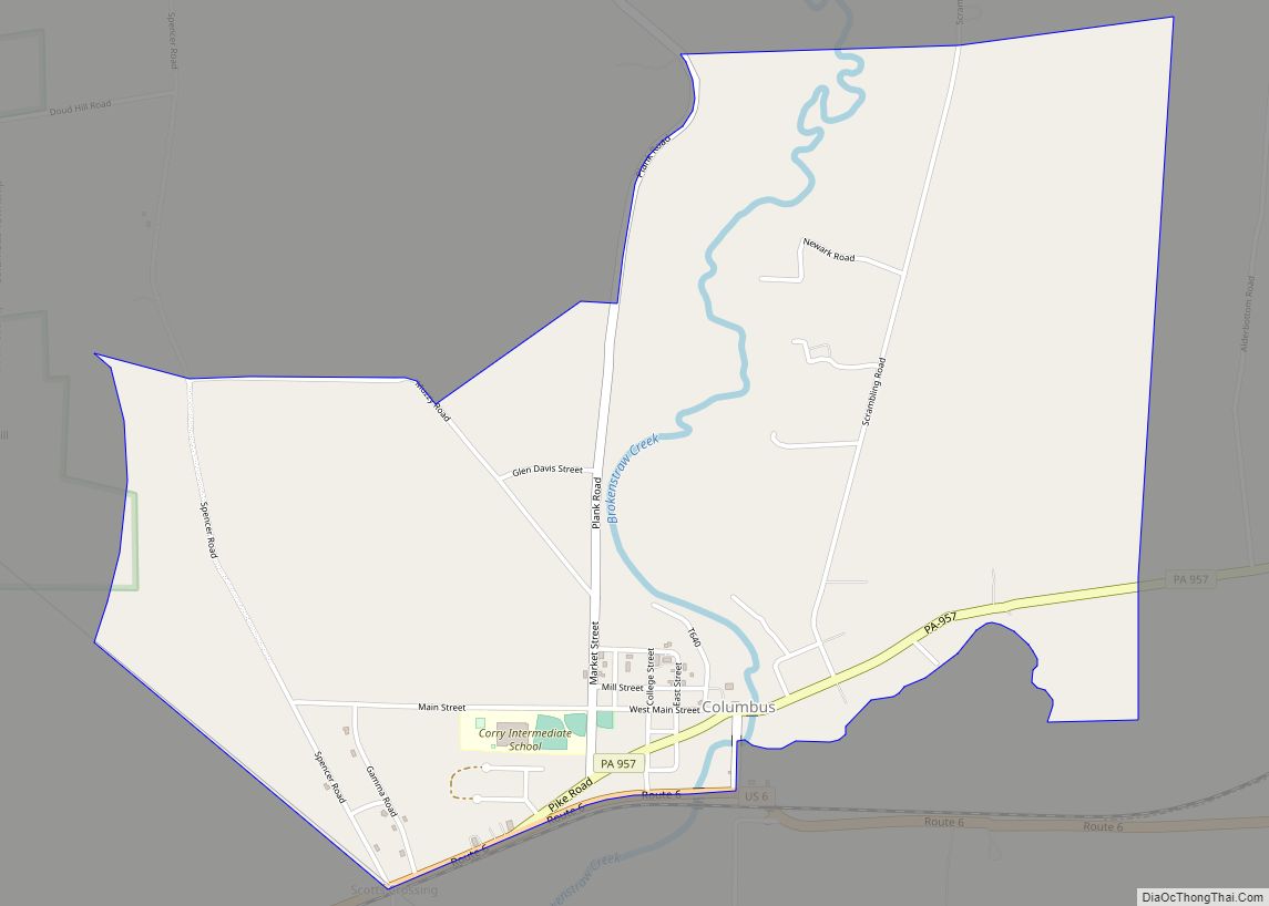
Map of Columbia borough, Pennsylvania
Columbia borough overview: Name: Columbia borough LSAD Code: 21 LSAD Description: borough (suffix) State: Pennsylvania County: Lancaster County Elevation: 361 ft (110 m) Total Area: 2.42 sq mi (6.27 km²) Land Area: 2.41 sq mi (6.25 km²) Water Area: 0.01 sq mi (0.02 km²) Total Population: 10,207 Population Density: 4,228.25/sq mi (1,632.61/km²) ZIP code: 17512 Area code: 717 and 223 FIPS code: 4215384 Website: www.columbiapa.net Online Interactive ... Read more
Map of Columbia borough, Pennsylvania
Map of Colony Park CDP
Colony Park is a census-designated place in Spring Township, Berks County, Pennsylvania, United States. It is located just off U.S. 222, approximately one mile northwest of the borough of Wyomissing. As of the 2010 census, the population was 1,076 residents. Colony Park CDP overview: Name: Colony Park CDP LSAD Code: 57 LSAD Description: CDP (suffix) ... Read more
Map of Colony Park CDP
Map of Conshohocken borough
Conshohocken (/ˌkɒnʃəˈhɒkən/ kon-shə-HOK-ən; Lenape: Kanshihàkink) is a borough on the Schuylkill River in Montgomery County, Pennsylvania in suburban Philadelphia. Historically a large mill town and industrial and manufacturing center, after the decline of industry in recent years Conshohocken has developed into a center of riverfront commercial and residential development. In the regional slang, it is ... Read more
Map of Conshohocken borough
Map of Connoquenessing borough
Connoquenessing is a borough in Butler County, Pennsylvania, United States. The population was 528 at the 2010 census. Connoquenessing borough overview: Name: Connoquenessing borough LSAD Code: 21 LSAD Description: borough (suffix) State: Pennsylvania County: Butler County Incorporated: 1848 Total Area: 1.35 sq mi (3.51 km²) Land Area: 1.35 sq mi (3.51 km²) Water Area: 0.00 sq mi (0.00 km²) Total Population: 668 Population Density: ... Read more
Map of Connoquenessing borough
Map of Connellsville city
Connellsville is a city in Fayette County, Pennsylvania, United States, 36 miles (58 km) southeast of Pittsburgh and 50 miles (80 km) away via the Youghiogheny River, a tributary of the Monongahela River. It is part of the Pittsburgh Metro Area. The population was 7,637 at the 2010 census, a decline from the figure of 9,146 tabulated ... Read more
Map of Connellsville city
Map of Conneautville borough
Conneautville is a borough in Crawford County, Pennsylvania, United States, situated along Conneaut Creek. The population was 737 at the 2020 census, down from 774 at the 2010 census. Conneautville borough overview: Name: Conneautville borough LSAD Code: 21 LSAD Description: borough (suffix) State: Pennsylvania County: Crawford County Founded: 1843 Total Area: 1.12 sq mi (2.90 km²) Land Area: ... Read more
Map of Conneautville borough
Map of Conneaut Lakeshore CDP
Conneaut Lakeshore is a census-designated place (CDP) in Crawford County, Pennsylvania, United States. The population was 2,395 at the 2010 census. Conneaut Lakeshore CDP overview: Name: Conneaut Lakeshore CDP LSAD Code: 57 LSAD Description: CDP (suffix) State: Pennsylvania County: Crawford County Elevation: 1,080 ft (330 m) Total Area: 6.67 sq mi (17.28 km²) Land Area: 5.19 sq mi (13.43 km²) Water Area: 1.49 sq mi ... Read more
Map of Conneaut Lakeshore CDP
Map of Conneaut Lake borough
Conneaut Lake /ˈkɒniˌɔːt/ is a borough in Crawford County, Pennsylvania, located at the southern end of the lake of the same name. The population was 626 at the 2020 census, down from 653 at the 2010 census. Conneaut Lake borough overview: Name: Conneaut Lake borough LSAD Code: 21 LSAD Description: borough (suffix) State: Pennsylvania County: ... Read more
Map of Conneaut Lake borough
Map of Confluence borough
Confluence is a borough in Somerset County, Pennsylvania, United States. It is part of the Johnstown, Pennsylvania, Metropolitan Statistical Area. The population was 724 at the 2020 census. Confluence borough overview: Name: Confluence borough LSAD Code: 21 LSAD Description: borough (suffix) State: Pennsylvania County: Somerset County Incorporated: 1873 Total Area: 1.68 sq mi (4.35 km²) Land Area: 1.60 sq mi ... Read more
Map of Confluence borough
Map of Conestoga CDP
Conestoga is an unincorporated community and census-designated place (CDP) in Conestoga Township, Lancaster County, Pennsylvania, United States. At the 2010 census, the population was 1,258. The Conestoga post office serves ZIP code 17516. Conestoga CDP overview: Name: Conestoga CDP LSAD Code: 57 LSAD Description: CDP (suffix) State: Pennsylvania County: Lancaster County Elevation: 500 ft (200 m) Total ... Read more
Map of Conestoga CDP
Map of Conashaugh Lakes CDP
Conashaugh Lakes is a census-designated place located in Dingman Township, Pike County in the state of Pennsylvania. The community is located off Pennsylvania Route 739 to the south of Interstate 84. As of the 2020 census the population was 1,425 residents. Conashaugh Lakes CDP overview: Name: Conashaugh Lakes CDP LSAD Code: 57 LSAD Description: CDP ... Read more
Map of Conashaugh Lakes CDP
Map of Commodore CDP
Commodore is a census-designated place (CDP) in Green Township, Indiana County, Pennsylvania, United States. The population was 331 at the 2010 census. Commodore CDP overview: Name: Commodore CDP LSAD Code: 57 LSAD Description: CDP (suffix) State: Pennsylvania County: Indiana County Elevation: 1,420 ft (430 m) Total Area: 0.84 sq mi (2.17 km²) Land Area: 0.83 sq mi (2.16 km²) Water Area: 0.01 sq mi (0.01 km²) ... Read more
Map of Commodore CDP