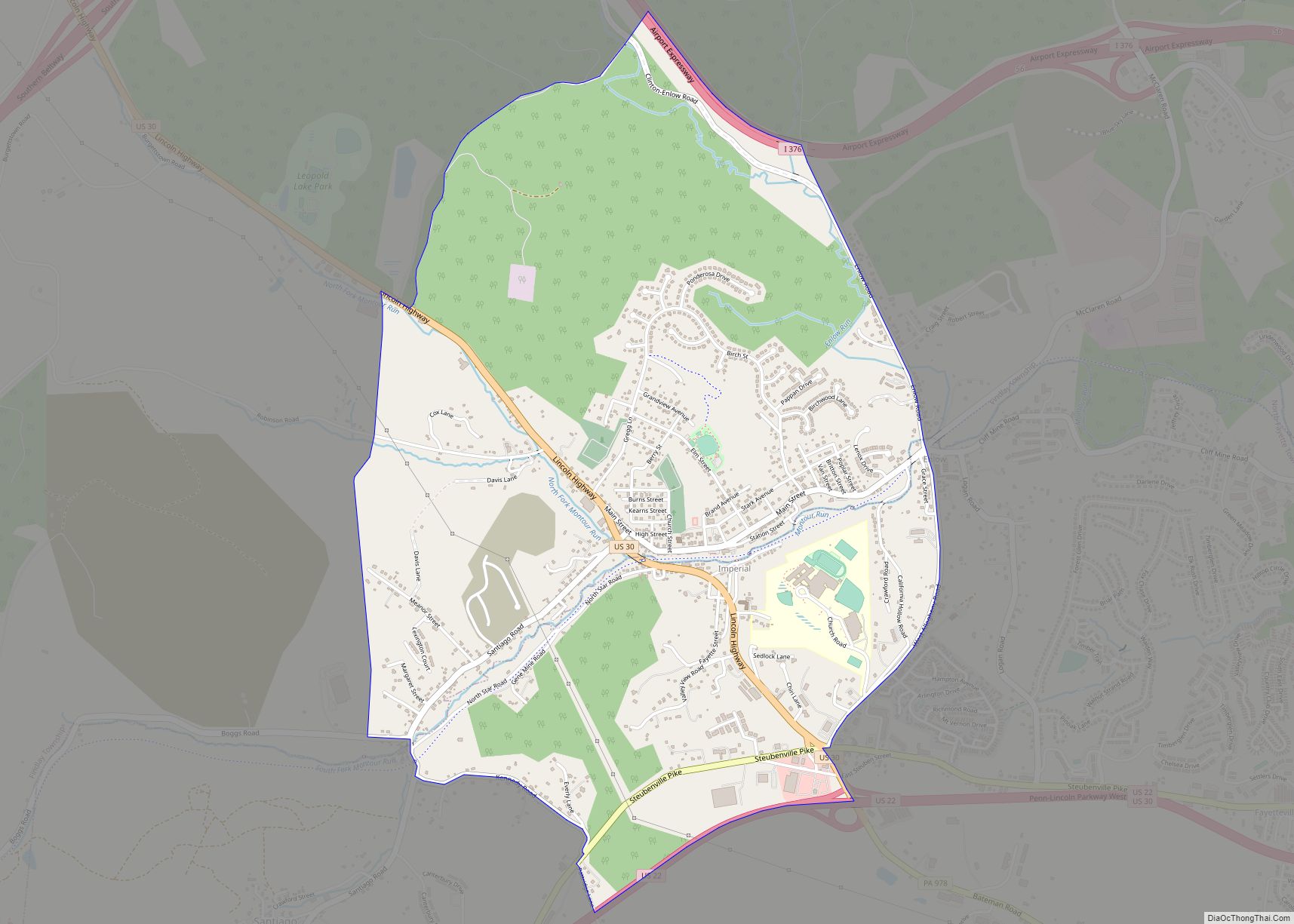
Map of Hunker borough
Hunker is a borough which is located in Westmoreland County, Pennsylvania, United States. It has been part of the Pittsburgh metropolitan area since 1950. The population was 307 at the time of the 2020 census. Hunker borough overview: Name: Hunker borough LSAD Code: 21 LSAD Description: borough (suffix) State: Pennsylvania County: Westmoreland County Incorporated: 1929 ... Read more
Map of Hunker borough
Map of Hummelstown borough
Hummelstown is a borough in Dauphin County, Pennsylvania, United States. The population was 4,535 as of the 2020 census. It is part of the Harrisburg–Carlisle Metropolitan Statistical Area. Originally named Fredrickstown, the town was established in 1762. The current mayor is David Roeting. Hummelstown is a Tree City and is located in District 15 of ... Read more
Map of Hummelstown borough
Map of Hummels Wharf CDP
Hummels Wharf is a census-designated place (CDP) in Snyder County, Pennsylvania, United States. The population was 641 at the 2000 census. Hummels Wharf CDP overview: Name: Hummels Wharf CDP LSAD Code: 57 LSAD Description: CDP (suffix) State: Pennsylvania County: Snyder County Total Area: 0.80 sq mi (2.07 km²) Land Area: 0.79 sq mi (2.04 km²) Water Area: 0.01 sq mi (0.02 km²) Total Population: ... Read more
Map of Hummels Wharf CDP
Map of Idaville CDP, Pennsylvania
Idaville is a census-designated place in Huntington Township, Adams County, Pennsylvania, United States. As of the 2020 census its population was 176. Idaville is served by the Bermudian Springs School District. Idaville CDP overview: Name: Idaville CDP LSAD Code: 57 LSAD Description: CDP (suffix) State: Pennsylvania County: Adams County Elevation: 804 ft (245 m) Total Area: 0.70 sq mi ... Read more
Map of Idaville CDP, Pennsylvania
Map of Hyndman borough
Hyndman is a borough in Bedford County, Pennsylvania, United States. As of the 2020 census, the population was 859. Hyndman borough overview: Name: Hyndman borough LSAD Code: 21 LSAD Description: borough (suffix) State: Pennsylvania County: Bedford County Incorporated: 1877 Elevation: 1,404 ft (428 m) Total Area: 0.53 sq mi (1.37 km²) Land Area: 0.51 sq mi (1.32 km²) Water Area: 0.02 sq mi (0.04 km²) Total ... Read more
Map of Hyndman borough
Map of Hydetown borough
Hydetown is a borough in Crawford County, Pennsylvania, United States. The population was 530 at the 2020 census, up from 526 at the 2010 census, down from 605 in 2000. It was established in 1862. Hydetown borough overview: Name: Hydetown borough LSAD Code: 21 LSAD Description: borough (suffix) State: Pennsylvania County: Crawford County Founded: 1862 ... Read more
Map of Hydetown borough
Map of Irvona borough
Irvona is a borough in Clearfield County, Pennsylvania, United States. The population was 549 at the 2020 census. Irvona borough overview: Name: Irvona borough LSAD Code: 21 LSAD Description: borough (suffix) State: Pennsylvania County: Clearfield County Incorporated: 1890 Elevation: 1,379 ft (420 m) Total Area: 0.95 sq mi (2.46 km²) Land Area: 0.93 sq mi (2.41 km²) Water Area: 0.02 sq mi (0.05 km²) Total Population: ... Read more
Map of Irvona borough
Map of Iola CDP, Pennsylvania
Iola is a census-designated place in Columbia County, Pennsylvania, United States. It is part of Northeastern Pennsylvania. The population was 144 at the 2010 census. It is part of the Bloomsburg-Berwick micropolitan area. Iola CDP overview: Name: Iola CDP LSAD Code: 57 LSAD Description: CDP (suffix) State: Pennsylvania County: Columbia County Elevation: 653 ft (199 m) Total ... Read more
Map of Iola CDP, Pennsylvania
Map of Intercourse CDP
Intercourse is an unincorporated community and census-designated place (CDP) in Leacock Township, Lancaster County, in the U.S. state of Pennsylvania, 10 miles (16 km) east of Lancaster on Pennsylvania Route 340. As of the 2020 census, the population was 1,494, up from 1,274 at the previous census. Intercourse is a popular site for tourists because of ... Read more
Map of Intercourse CDP
Map of Inkerman CDP
Inkerman is a census-designated place (CDP) in Jenkins Township, Luzerne County, Pennsylvania, United States. The population was 1,819 at the 2010 census. Inkerman CDP overview: Name: Inkerman CDP LSAD Code: 57 LSAD Description: CDP (suffix) State: Pennsylvania County: Luzerne County Total Area: 0.73 sq mi (1.89 km²) Land Area: 0.73 sq mi (1.89 km²) Water Area: 0.00 sq mi (0.00 km²) Total Population: 1,720 ... Read more
Map of Inkerman CDP
Map of Ingram borough, Pennsylvania
Ingram is a borough in Allegheny County, Pennsylvania, United States. The population was 3,391 at the 2020 census. Ingram borough overview: Name: Ingram borough LSAD Code: 21 LSAD Description: borough (suffix) State: Pennsylvania County: Allegheny County Total Area: 0.43 sq mi (1.12 km²) Land Area: 0.43 sq mi (1.12 km²) Water Area: 0.00 sq mi (0.00 km²) Total Population: 3,391 Population Density: 7,813.36/sq mi (3,020.09/km²) ... Read more
Map of Ingram borough, Pennsylvania
Map of Industry borough, Pennsylvania
Industry is a borough in Beaver County, Pennsylvania, along the Ohio River. As of the 2020 census, the population was 1,833. It is part of the Pittsburgh metropolitan area. Industry borough overview: Name: Industry borough LSAD Code: 21 LSAD Description: borough (suffix) State: Pennsylvania County: Beaver County Elevation: 1,040 ft (320 m) Total Area: 10.98 sq mi (28.43 km²) Land ... Read more
Map of Industry borough, Pennsylvania