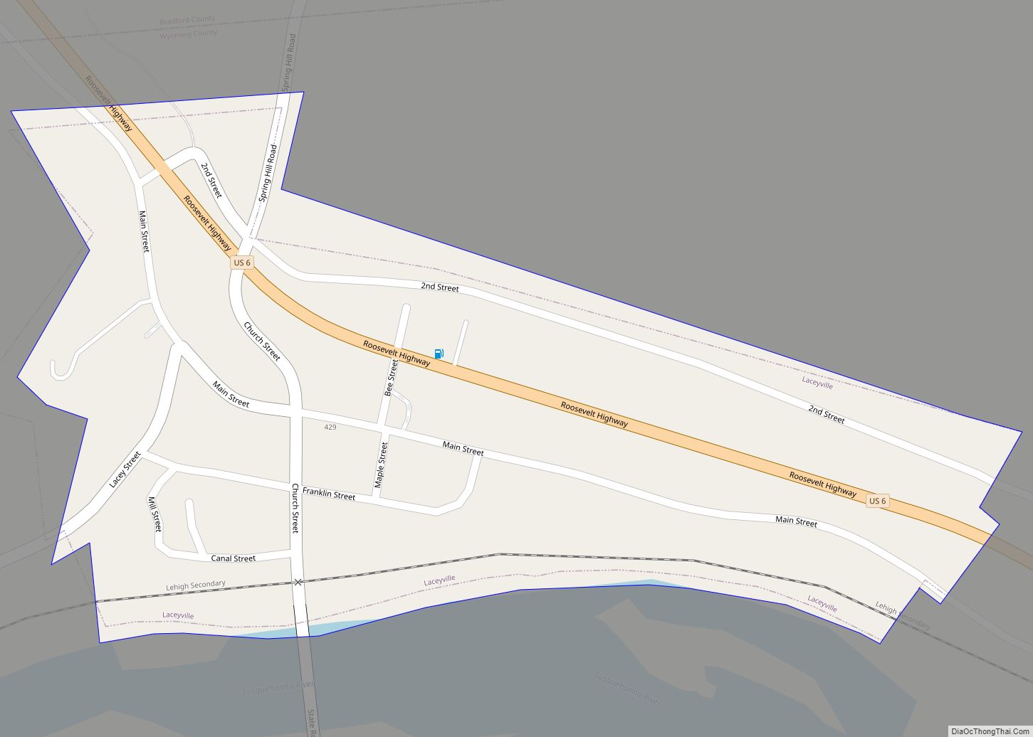
Map of Kulpmont borough
Kulpmont is a borough in Northumberland County, Pennsylvania, United States. The population was 2,924 at the 2010 census. Kulpmont borough overview: Name: Kulpmont borough LSAD Code: 21 LSAD Description: borough (suffix) State: Pennsylvania County: Northumberland County Incorporated: 1915 Total Area: 0.96 sq mi (2.48 km²) Land Area: 0.96 sq mi (2.48 km²) Water Area: 0.00 sq mi (0.00 km²) Total Population: 2,758 Population Density: ... Read more
Map of Kulpmont borough
Map of Kreamer CDP
Kreamer is a census-designated place (CDP) in Middlecreek Township, Snyder County, Pennsylvania, United States. The population was 773 at the 2000 census. In May 2019, Wood-Mode, a major local employer, shut down its cabinetmaking operation in Kreamer. Press reports indicated the unexpected closing of the county’s largest single employer cost nine-hundred people their jobs. Kreamer ... Read more
Map of Kreamer CDP
Map of Lake City borough, Pennsylvania
Lake City is a borough in Erie County, Pennsylvania, United States. The population was 2,936 at the 2020 census. It is part of the Erie Metropolitan Statistical Area. Lake City borough overview: Name: Lake City borough LSAD Code: 21 LSAD Description: borough (suffix) State: Pennsylvania County: Erie County Total Area: 1.80 sq mi (4.68 km²) Land Area: 1.80 sq mi ... Read more
Map of Lake City borough, Pennsylvania
Map of Lake Arthur Estates CDP
Lake Arthur Estates is a census-designated place and mobile home court located in Muddy Creek Township, Butler County, in the U.S. state of Pennsylvania. Located near the intersections of I-79 and US 422, the village is situated west of Lake Arthur, a reservoir on Muddy Creek. The community is also just west of Moraine State ... Read more
Map of Lake Arthur Estates CDP
Map of Landingville borough
Landingville is a borough in Schuylkill County, Pennsylvania, United States. The population was 137 at the time of the 2020 census. Landingville borough overview: Name: Landingville borough LSAD Code: 21 LSAD Description: borough (suffix) State: Pennsylvania County: Schuylkill County Incorporated: 1887 Total Area: 0.86 sq mi (2.22 km²) Land Area: 0.86 sq mi (2.22 km²) Water Area: 0.00 sq mi (0.00 km²) Total Population: ... Read more
Map of Landingville borough
Map of Lancaster city, Pennsylvania
Lancaster (/ˈlæŋkɪstər/ LANG-ki-stər; Pennsylvania German: Lengeschder) is a city in and the county seat of Lancaster County, Pennsylvania, and one of the oldest inland cities in the United States. With a population at the 2020 census of 58,039, it ranks 11th in population among Pennsylvania’s municipalities. The Lancaster metropolitan area population is 552,984, making it ... Read more
Map of Lancaster city, Pennsylvania
Map of Lampeter CDP
Lampeter is an unincorporated community and census-designated place (CDP) in West Lampeter Township, Lancaster County, Pennsylvania, United States. As of the 2010 census, it had a population of 1,669. It is a suburb of Lancaster and has a ZIP code of 17537. The community was named after Lampeter, in Wales. Lampeter CDP overview: Name: Lampeter ... Read more
Map of Lampeter CDP
Map of Lamar CDP, Pennsylvania
Lamar is a census-designated place in Porter Township in southern Clinton County, Pennsylvania, United States. As of the 2010 census the population was 562. The community is located along Pennsylvania Route 64 in southern Clinton County and is bordered on the west by Nittany in Walker Township, Centre County. PA 64 leads northeast 1 mile ... Read more
Map of Lamar CDP, Pennsylvania
Map of Lakemont CDP
Lakemont is a census-designated place in Allegheny and Logan Townships in Blair County, Pennsylvania, United States. It is located to the east of I-99 and is located between Altoona and Hollidaysburg. Lakemont is the location of Lakemont Park, although the address is generally Altoona and part of the “Lakemont” area actually lies within the Altoona ... Read more
Map of Lakemont CDP
Map of Lake Wynonah CDP
Lake Wynonah is a census-designated place (CDP) in Schuylkill County, Pennsylvania, United States. The population was 1,961 at the 2000 census, and 2,640 at the 2010 census. Lake Wynonah is a gated community with two lakes, Fawn Lake and Lake Wynonah, and as of July 2008, there are over 1200 homes and 1500 members. It ... Read more
Map of Lake Wynonah CDP
Map of Lake Winola CDP
Lake Winola is a census-designated place located in Overfield Township, Wyoming County in the state of Pennsylvania. The community is located along Pennsylvania Route 307. As of the 2010 census the population was 748 residents. Lake Winola CDP overview: Name: Lake Winola CDP LSAD Code: 57 LSAD Description: CDP (suffix) State: Pennsylvania County: Wyoming County ... Read more
Map of Lake Winola CDP
Map of Lake Meade CDP
Lake Meade is an unincorporated census-designated place in Latimore and Reading townships, Adams County, Pennsylvania, United States. The population was 2,539 at the 2020 census. Lake Meade CDP overview: Name: Lake Meade CDP LSAD Code: 57 LSAD Description: CDP (suffix) State: Pennsylvania County: Adams County Elevation: 499 ft (152 m) Total Area: 1.74 sq mi (4.51 km²) Land Area: 1.32 sq mi ... Read more
Map of Lake Meade CDP