Map of Lumber City CDP, Pennsylvania
Lumber City is a census-designated place located in Brown Township, Mifflin County in the state of Pennsylvania, United States. It is located just off US 322 in central Mifflin County, very close to the community of Reedsville. As of the 2010 census, the population was 255 residents. Lumber City CDP overview: Name: Lumber City CDP ... Read more
Map of Lumber City CDP, Pennsylvania
Map of Lucerne Mines CDP
Lucernemines, usually written as Lucerne Mines, is a census-designated place (CDP) in Indiana County, Pennsylvania, United States. The population was 937 at the 2010 census. Lucerne Mines CDP overview: Name: Lucerne Mines CDP LSAD Code: 57 LSAD Description: CDP (suffix) State: Pennsylvania County: Indiana County Total Area: 0.84 sq mi (2.18 km²) Land Area: 0.84 sq mi (2.17 km²) Water Area: ... Read more
Map of Lucerne Mines CDP
Map of Loyalhanna CDP
Loyalhanna is a census-designated place (CDP) in Westmoreland County, Pennsylvania, United States. The population was 3,415 at the 2000 census, at which time it was listed as McChesneytown-Loyalhanna, before just becoming the CDP of Loyalhanna for the 2010 census. As of the 2010 census the population was 3,428 residents. Loyalhanna CDP overview: Name: Loyalhanna CDP ... Read more
Map of Loyalhanna CDP
Map of Lower Burrell city
Lower Burrell is a city in northern Westmoreland County, Pennsylvania, United States, along the Allegheny River. Located approximately 18 miles northeast of downtown Pittsburgh, it is part of the Pittsburgh metropolitan area. The population was 11,758 at the 2020 census. Lower Burrell city overview: Name: Lower Burrell city LSAD Code: 25 LSAD Description: city (suffix) ... Read more
Map of Lower Burrell city
Map of Lower Allen CDP
Lower Allen is a census-designated place (CDP) in Lower Allen Township in Cumberland County, Pennsylvania, United States. The population was 6,694 at the 2010 census. It is part of the Harrisburg–Carlisle metropolitan statistical area. Lower Allen CDP overview: Name: Lower Allen CDP LSAD Code: 57 LSAD Description: CDP (suffix) State: Pennsylvania County: Cumberland County Elevation: ... Read more
Map of Lower Allen CDP
Map of Loretto borough, Pennsylvania
Loretto is a borough in Cambria County, Pennsylvania, United States. As of the 2010 census it had a population of 1,302. Like the rest of Cambria County, it is part of the Johnstown, Pennsylvania Metropolitan Statistical Area. Loretto is the home of Saint Francis University. Loretto borough overview: Name: Loretto borough LSAD Code: 21 LSAD ... Read more
Map of Loretto borough, Pennsylvania
Map of Lorane CDP
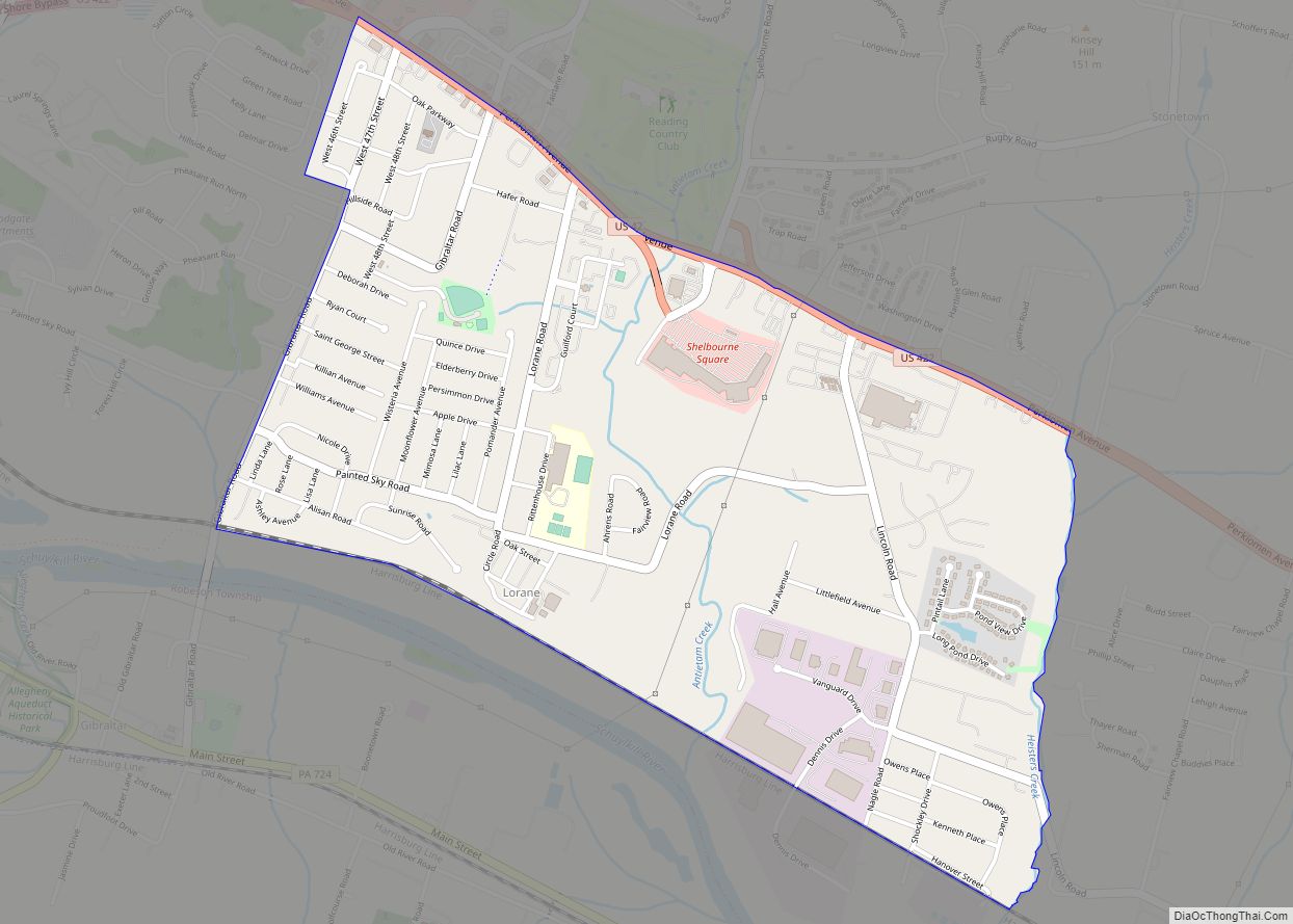
Lorane is a census-designated place (CDP) in Exeter Township, Berks County, Pennsylvania. The population was 4,236 at the 2010 census. Located on the Schuylkill River, US Route 422 runs through the town. Lorane CDP overview: Name: Lorane CDP LSAD Code: 57 LSAD Description: CDP (suffix) State: Pennsylvania County: Berks County Elevation: 203 ft (62 m) Total Area: ... Read more
Map of Lorane CDP
Map of Lorain borough, Pennsylvania
Lorain is a borough in Cambria County, Pennsylvania, United States. It is part of the Johnstown, Pennsylvania Metropolitan Statistical Area. The population was 759 at the 2010 census. Lorain borough overview: Name: Lorain borough LSAD Code: 21 LSAD Description: borough (suffix) State: Pennsylvania County: Cambria County Incorporated: 1915 Elevation: 1,457 ft (444 m) Total Area: 0.34 sq mi (0.89 km²) ... Read more
Map of Lorain borough, Pennsylvania
Map of Longfellow CDP
Longfellow is a census-designated place located in Bratton Township, Mifflin County in the state of Pennsylvania, United States. It is located along Pennsylvania Route 103 in southern Mifflin County. As of the 2010 census, the population was 215 residents. Longfellow CDP overview: Name: Longfellow CDP LSAD Code: 57 LSAD Description: CDP (suffix) State: Pennsylvania County: ... Read more
Map of Longfellow CDP
Map of Long Branch borough, Pennsylvania
Long Branch is a borough in Washington County, Pennsylvania, United States. The population was 421 at the 2020 census. Long Branch borough overview: Name: Long Branch borough LSAD Code: 21 LSAD Description: borough (suffix) State: Pennsylvania County: Washington County Total Area: 3.19 sq mi (8.26 km²) Land Area: 3.19 sq mi (8.26 km²) Water Area: 0.00 sq mi (0.00 km²) Total Population: 421 Population ... Read more
Map of Long Branch borough, Pennsylvania
Map of Lyons borough, Pennsylvania
Lyons (also known as Lyon Station) is a borough in Berks County, Pennsylvania, United States. The population was 478 at the 2010 census. Lyons borough overview: Name: Lyons borough LSAD Code: 21 LSAD Description: borough (suffix) State: Pennsylvania County: Berks County Elevation: 476 ft (145 m) Total Area: 0.36 sq mi (0.92 km²) Land Area: 0.36 sq mi (0.92 km²) Water Area: 0.00 sq mi ... Read more
Map of Lyons borough, Pennsylvania
Map of Lynnwood-Pricedale CDP
Lynnwood-Pricedale is a census-designated place (CDP) in Fayette and Westmoreland counties in the commonwealth of Pennsylvania, United States. The population was 2,031 at the 2010 census, down from 2,168 at the 2000 census. The community of Lynwood is located in Fayette County’s Washington Township, while Pricedale is part of Westmoreland County’s Rostraver Township. Lynnwood-Pricedale CDP ... Read more
Map of Lynnwood-Pricedale CDP