Map of Mifflintown borough
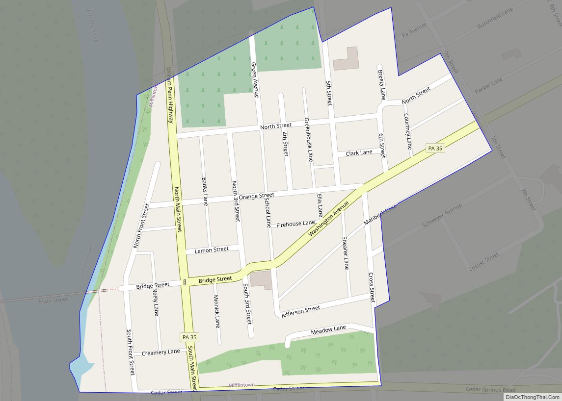
Mifflintown is a borough in and the county seat of Juniata County, Pennsylvania, United States. The population was 842 at the 2020 census. Mifflintown borough overview: Name: Mifflintown borough LSAD Code: 21 LSAD Description: borough (suffix) State: Pennsylvania County: Juniata County Incorporated: 1833 Total Area: 0.14 sq mi (0.36 km²) Land Area: 0.14 sq mi (0.36 km²) Water Area: 0.00 sq mi (0.00 km²) ... Read more
Map of Mifflintown borough
Map of Mifflinburg borough
Mifflinburg is a borough in Union County, located in the Susquehanna River Valley of central Pennsylvania, United States. Mifflinburg was first settled in 1792 by Elias and Catharina Jungman (later Youngman) and their two children. They divided the land into 60′ by 120′ plots that were sold to other settlers, many of them German, and ... Read more
Map of Mifflinburg borough
Map of Mifflin borough, Pennsylvania
Mifflin is a borough in Juniata County, Pennsylvania, United States. The population was 534 at the 2020 census. Mifflin borough overview: Name: Mifflin borough LSAD Code: 21 LSAD Description: borough (suffix) State: Pennsylvania County: Juniata County Incorporated: 1853 Total Area: 0.17 sq mi (0.45 km²) Land Area: 0.17 sq mi (0.45 km²) Water Area: 0.00 sq mi (0.00 km²) Total Population: 530 Population Density: ... Read more
Map of Mifflin borough, Pennsylvania
Map of Midway CDP, Pennsylvania
Midway is an unincorporated census-designated place in Adams County, Pennsylvania, United States. The population was 1,059 at the 2020 census. Midway CDP overview: Name: Midway CDP LSAD Code: 57 LSAD Description: CDP (suffix) State: Pennsylvania County: Adams County Elevation: 597 ft (182 m) Total Area: 0.33 sq mi (0.86 km²) Land Area: 0.33 sq mi (0.86 km²) Water Area: 0.00 sq mi (0.00 km²) Total Population: ... Read more
Map of Midway CDP, Pennsylvania
Map of Millville borough, Pennsylvania
Millville is a borough in Columbia County, Pennsylvania, United States. It is part of Northeastern Pennsylvania. As of the 2020 census it had a population of 976. It is part of the Bloomsburg-Berwick micropolitan area. Millville borough overview: Name: Millville borough LSAD Code: 21 LSAD Description: borough (suffix) State: Pennsylvania County: Columbia County Incorporated: 1892 ... Read more
Map of Millville borough, Pennsylvania
Map of Millvale borough
Millvale is a borough in Allegheny County, Pennsylvania, United States, along the Allegheny River, opposite Pittsburgh. The borough is located off Pennsylvania Route 28. The population was 3,376 at the 2020 census. Millvale borough overview: Name: Millvale borough LSAD Code: 21 LSAD Description: borough (suffix) State: Pennsylvania County: Allegheny County Total Area: 0.68 sq mi (1.75 km²) Land ... Read more
Map of Millvale borough
Map of Millsboro CDP, Pennsylvania
Millsboro is a census-designated place located in East Bethlehem Township, Washington County, Pennsylvania. The community was part of the Fredericktown-Millsboro CDP for the 2000 census but was split into two separate CDPs for the 2010 census, the other community being Fredericktown. Millsboro is located in far southern Washington County, along Pennsylvania Route 88, which travels ... Read more
Map of Millsboro CDP, Pennsylvania
Map of Millheim borough
Millheim is a borough in Centre County, Pennsylvania, United States. It is part of the State College, Pennsylvania Metropolitan Statistical Area. The population was 904 at the 2010 census. The Millheim Historic District, which includes 176 contributing buildings, was listed on the National Register of Historic Places in 1986. Millheim borough overview: Name: Millheim borough ... Read more
Map of Millheim borough
Map of Millerton CDP, Pennsylvania
Millerton is a census-designated place in Jackson Township, Tioga County, Pennsylvania, United States with the ZIP code 16936. It is located in far northeastern Tioga County, a few miles from the New York border. The community is situated along Pennsylvania Route 328. As of the 2010 census, the population was 316 residents. Millerton CDP overview: ... Read more
Map of Millerton CDP, Pennsylvania
Map of Millersville borough, Pennsylvania
Millersville is a borough in Lancaster County, Pennsylvania, United States. At the 2020 census the population was 7,629 and in 2021 it was estimated at 7,593. Millersville borough overview: Name: Millersville borough LSAD Code: 21 LSAD Description: borough (suffix) State: Pennsylvania County: Lancaster County Elevation: 315 ft (96 m) Total Area: 1.94 sq mi (5.03 km²) Land Area: 1.93 sq mi (5.01 km²) ... Read more
Map of Millersville borough, Pennsylvania
Map of Millerstown borough
Millerstown is a borough in northern Perry County, Pennsylvania, United States, located (via road) 29 miles (47 km) northwest of Harrisburg and 29 miles (47 km) southwest of Selinsgrove. The population was 688 at the 2020 Census. The borough is part of the Harrisburg–Carlisle Metropolitan Statistical Area. Millerstown borough overview: Name: Millerstown borough LSAD Code: 21 LSAD ... Read more
Map of Millerstown borough
Map of Millersburg borough, Pennsylvania
Millersburg is a borough in Dauphin County, Pennsylvania, United States. The population was 2,541 at the 2020 census. It is part of the Harrisburg–Carlisle Metropolitan Statistical Area. Millersburg borough overview: Name: Millersburg borough LSAD Code: 21 LSAD Description: borough (suffix) State: Pennsylvania County: Dauphin County Incorporated: 1850 Elevation: 430 ft (130 m) Total Area: 0.76 sq mi (1.97 km²) Land ... Read more
Map of Millersburg borough, Pennsylvania