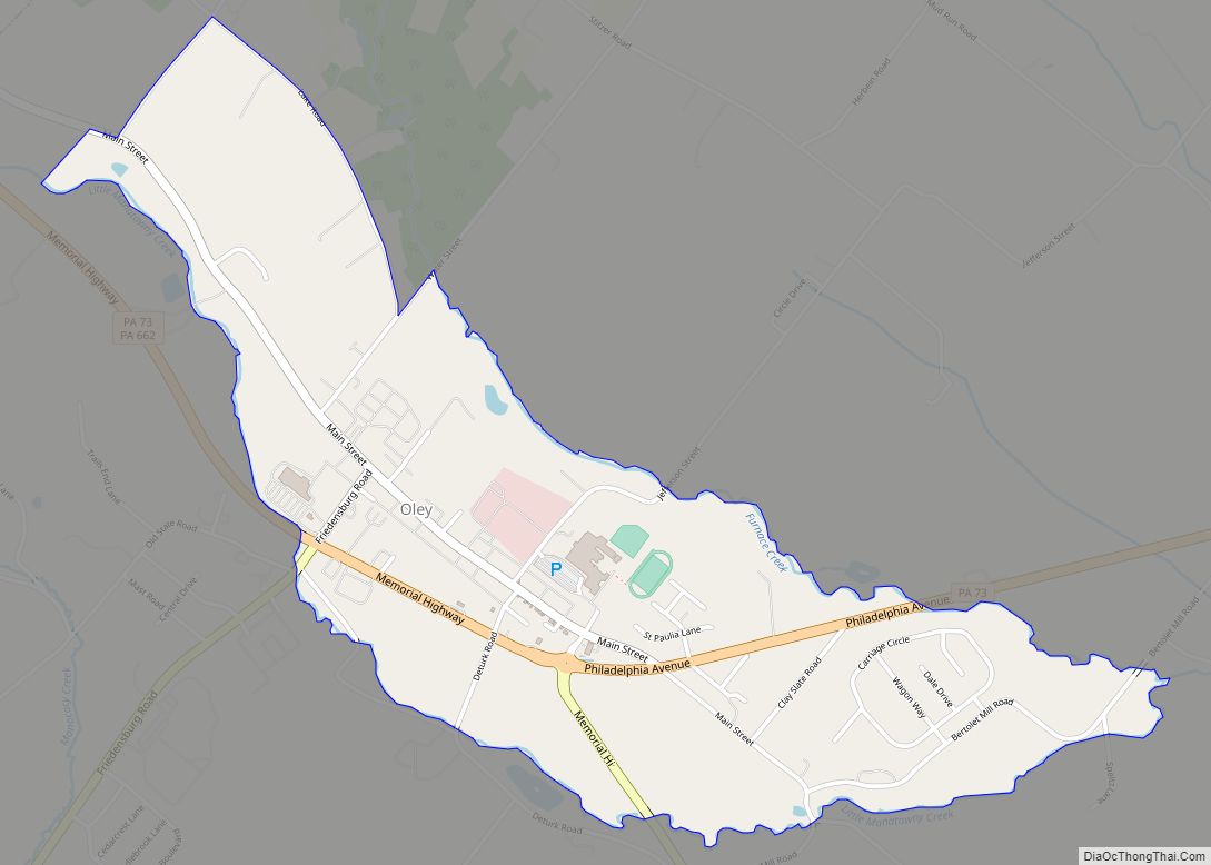
Map of Oil City, Pennsylvania
Oil City is a city in Venango County, Pennsylvania, United States. Known for its prominence in the initial exploration and development of the petroleum industry, it is located at a bend in the Allegheny River at the mouth of Oil Creek. Initial settlement of Oil City was sporadic, and tied to the iron industry. After ... Read more
Map of Oil City, Pennsylvania
Map of Ohioville borough
Ohioville is a borough in western Beaver County, Pennsylvania, United States. The population was 3,345 at the 2020 census. It is part of the Pittsburgh metropolitan area. Ohioville borough overview: Name: Ohioville borough LSAD Code: 21 LSAD Description: borough (suffix) State: Pennsylvania County: Beaver County Incorporated: 1860 Elevation: 1,253 ft (382 m) Total Area: 23.69 sq mi (61.36 km²) Land ... Read more
Map of Ohioville borough
Map of Ohiopyle borough
Ohiopyle is a borough in Fayette County, Pennsylvania, United States. The population was 38 at the 2020 census. While Ohiopyle has a tiny year-round population, it is often filled with tourists on the weekend, who come for the outdoor recreation opportunities at the surrounding Ohiopyle State Park, as well as the Great Allegheny Passage bicycle ... Read more
Map of Ohiopyle borough
Map of Oberlin CDP, Pennsylvania
Oberlin is an unincorporated community and census-designated place (CDP) located in Swatara Township, Dauphin County, Pennsylvania, United States. The community was part of the census-designated place of Bressler-Enhaut-Oberlin, before it was split into three separate CDPs for the 2010 census. As of the 2010 census, the population was 588. Oberlin CDP overview: Name: Oberlin CDP ... Read more
Map of Oberlin CDP, Pennsylvania
Map of Olyphant borough
Olyphant is a borough in Lackawanna County, Pennsylvania, United States. It is six miles (10 km) northeast of downtown Scranton, on the Lackawanna River in the heart of the anthracite region of the state. Its main source of employment was the mining and shipping of coal. It was the headquarters of the Lackawanna Coal Company. Other ... Read more
Map of Olyphant borough
Map of Oliver CDP, Pennsylvania
Oliver is a census-designated place (CDP) in Fayette County, Pennsylvania, United States. The population was 2,535 at the 2010 census, down from 2,925 at the 2000 census. Oliver is located in North Union Township. Oliver CDP overview: Name: Oliver CDP LSAD Code: 57 LSAD Description: CDP (suffix) State: Pennsylvania County: Fayette County Total Area: 2.22 sq mi ... Read more
Map of Oliver CDP, Pennsylvania
Map of Orwin CDP
Orwin is a census-designated place located in Porter Township, Schuylkill County in the state of Pennsylvania, United States. Orwin was part of the Reinerton-Orwin-Muir CDP at the 2000 census before splitting into three individual CDPs for the 2010 census. The other communities, along with Orwin are Reinerton and Muir. The community is located near the ... Read more
Map of Orwin CDP
Map of Orwigsburg borough
Orwigsburg is a borough in Schuylkill County, Pennsylvania. The borough was named for its founder, Peter Orwig, and created from West Brunswick Township in 1823. It was the original county seat until the seat was moved to Pottsville in 1851. The population was 2,995 at the time of the 2020 census. Orwigsburg borough overview: Name: ... Read more
Map of Orwigsburg borough
Map of Orviston CDP
Orviston is an unincorporated community and census-designated place (CDP) in Curtin Township, Centre County, Pennsylvania, United States. As of the 2010 census, the population was 95. It is located in far northern Centre County, near the Clinton County border. Beech Creek runs through the center of the town, flowing southeast towards Bald Eagle Creek in ... Read more
Map of Orviston CDP
Map of Orrtanna CDP
Orrtanna is a census-designated place (CDP) in Adams County, Pennsylvania, United States. The population was 183 at the 2020 census. Orrtanna CDP overview: Name: Orrtanna CDP LSAD Code: 57 LSAD Description: CDP (suffix) State: Pennsylvania County: Adams County Elevation: 670 ft (200 m) Total Area: 0.21 sq mi (0.53 km²) Land Area: 0.20 sq mi (0.53 km²) Water Area: 0.00 sq mi (0.01 km²) Total Population: ... Read more
Map of Orrtanna CDP
Map of Orrstown borough
Orrstown is a borough in Franklin County, Pennsylvania, United States. The population was 214 at the 2020 census. Orrstown borough overview: Name: Orrstown borough LSAD Code: 21 LSAD Description: borough (suffix) State: Pennsylvania County: Franklin County Elevation: 686 ft (209 m) Total Area: 0.06 sq mi (0.16 km²) Land Area: 0.06 sq mi (0.16 km²) Water Area: 0.00 sq mi (0.00 km²) Total Population: 214 Population ... Read more
Map of Orrstown borough
Map of Oreland CDP
Oreland is a United States census-designated place (CDP) in Springfield and Upper Dublin townships, just outside the Chestnut Hill and Mount Airy areas of Philadelphia. Oreland has a ZIP code of 19075, and the population was 5,678 at the 2010 census. Oreland CDP overview: Name: Oreland CDP LSAD Code: 57 LSAD Description: CDP (suffix) State: ... Read more
Map of Oreland CDP