Map of Russellville CDP, South Carolina

Map of Russellville CDP, South Carolina

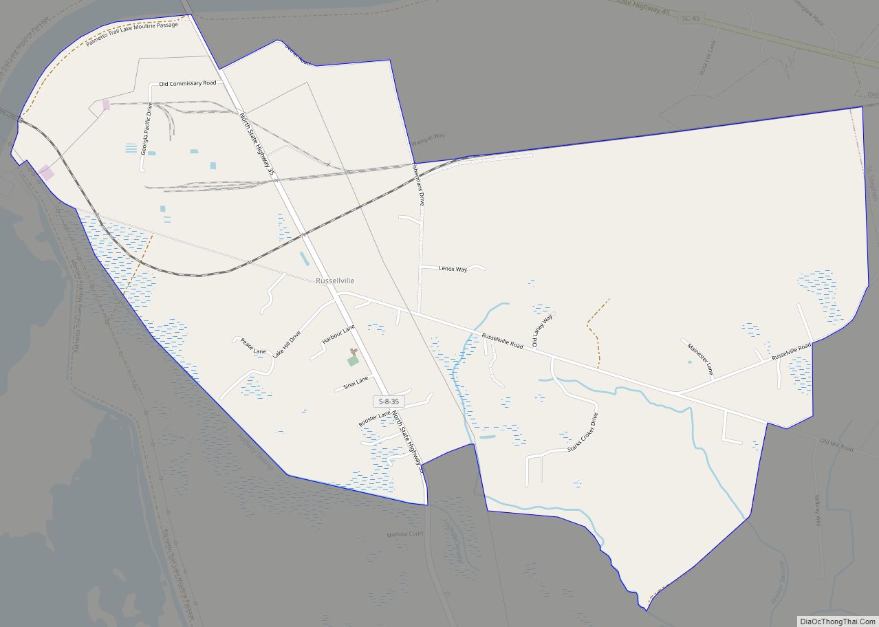
Russellville is a census-designated place and unincorporated community in Berkeley County, South Carolina, United States. Its population was 488 as of the 2010 census. Russellville CDP overview: Name: Russellville CDP LSAD Code: 57 LSAD Description: CDP (suffix) State: South Carolina County: Berkeley County Elevation: 79 ft (24 m) Total Area: 3.74 sq mi (9.70 km²) Land Area: 3.74 sq mi (9.70 km²) Water … Read more

Map of Ruby town, South Carolina

Map of Ruby town, South Carolina

Ruby is a town in Chesterfield County, South Carolina, United States. The population was 360 at the 2010 census. Ruby town overview: Name: Ruby town LSAD Code: 43 LSAD Description: town (suffix) State: South Carolina County: Chesterfield County Elevation: 387 ft (118 m) Total Area: 2.47 sq mi (6.40 km²) Land Area: 2.47 sq mi (6.40 km²) Water Area: 0.00 sq mi (0.00 km²) Total Population: … Read more

Map of Rowesville town

Map of Rowesville town

Rowesville is a town in Orangeburg County, South Carolina, United States. The population was 304 at the 2010 census. Rowesville town overview: Name: Rowesville town LSAD Code: 43 LSAD Description: town (suffix) State: South Carolina County: Orangeburg County Elevation: 167 ft (51 m) Total Area: 0.83 sq mi (2.16 km²) Land Area: 0.83 sq mi (2.16 km²) Water Area: 0.00 sq mi (0.00 km²) Total Population: … Read more

Map of Roebuck CDP

Map of Roebuck CDP

Roebuck is a census-designated place (CDP) in Spartanburg County, South Carolina, United States. The population was 2,200 at the 2010 census. Roebuck CDP overview: Name: Roebuck CDP LSAD Code: 57 LSAD Description: CDP (suffix) State: South Carolina County: Spartanburg County Elevation: 748 ft (228 m) Total Area: 4.31 sq mi (11.16 km²) Land Area: 4.29 sq mi (11.11 km²) Water Area: 0.02 sq mi (0.05 km²) … Read more

Map of Rockville town, South Carolina

Map of Rockville town, South Carolina

Rockville is a town in Charleston County, South Carolina, United States, that was founded in 1784. The population was 134 at the 2010 census. Rockville is part of the Charleston-North Charleston-Summerville metropolitan area. Rockville town overview: Name: Rockville town LSAD Code: 43 LSAD Description: town (suffix) State: South Carolina County: Charleston County Elevation: 10 ft (3 m) … Read more

Map of Shell Point CDP

Map of Shell Point CDP

Shell Point is a census-designated place (CDP) in Beaufort County, South Carolina, United States. The population was 2,336 at the 2010 census. As defined by the U.S. Census Bureau, Shell Point is in the Hilton Head Island−Bluffton, SC Metropolitan Statistical Area. Shell Point CDP overview: Name: Shell Point CDP LSAD Code: 57 LSAD Description: CDP … Read more

Map of Sharon town, South Carolina

Map of Sharon town, South Carolina

Sharon is a town in southwestern York County, South Carolina, United States. The population was 494 at the 2010 census. Sharon town overview: Name: Sharon town LSAD Code: 43 LSAD Description: town (suffix) State: South Carolina County: York County Elevation: 653 ft (199 m) Total Area: 1.31 sq mi (3.39 km²) Land Area: 1.31 sq mi (3.39 km²) Water Area: 0.00 sq mi (0.00 km²) Total … Read more

Map of Seven Oaks CDP

Map of Seven Oaks CDP, South Carolina

Seven Oaks is a census-designated place (CDP) in Lexington County, South Carolina, United States, 8 miles (13 km) northwest of downtown Columbia, the state capital. The population of the CDP was 15,144 at the 2010 census. It is part of the Columbia Metropolitan Statistical Area. Seven Oaks CDP overview: Name: Seven Oaks CDP LSAD Code: 57 … Read more

Map of Seneca city, South Carolina

Map of Seneca city, South Carolina

Seneca is a city in Oconee County, South Carolina, United States. The population was 8,102 at the 2010 census. It is the principal city of the Seneca Micropolitan Statistical Area (population 74,273 at the 2010 census), an (MSA) that includes all of Oconee County, and that is included within the greater Greenville–Spartanburg–Anderson, South Carolina Combined … Read more

Map of Sellers town

Map of Sellers town

Sellers is a small town in Marion County, South Carolina, United States. The population was 219 at the 2000 census. Sellers town overview: Name: Sellers town LSAD Code: 43 LSAD Description: town (suffix) State: South Carolina County: Marion County Elevation: 85 ft (26 m) Total Area: 0.67 sq mi (1.73 km²) Land Area: 0.67 sq mi (1.73 km²) Water Area: 0.00 sq mi (0.00 km²) Total … Read more

Map of Seabrook Island town

Map of Seabrook Island town

Seabrook Island, formerly known as Simmons Island, is a barrier island in Charleston County, South Carolina, United States. The population was 1,714 at the 2010 census, up from 1,250 in 2000. Seabrook Island is part of the Charleston-North Charleston-Summerville metropolitan area. Seabrook Island town overview: Name: Seabrook Island town LSAD Code: 43 LSAD Description: town … Read more

Map of Scranton town, South Carolina

Map of Scranton town, South Carolina

Scranton is a town in Florence County, South Carolina, United States. The population was 932 at the 2010 census. It is part of the Florence Metropolitan Statistical Area. Scranton town overview: Name: Scranton town LSAD Code: 43 LSAD Description: town (suffix) State: South Carolina County: Florence County Elevation: 95 ft (29 m) Total Area: 0.79 sq mi (2.05 km²) Land … Read more