Map of Bradley CDP, South Carolina

Map of Bradley CDP, South Carolina

Bradley is an unincorporated community and census-designated place (CDP) in Greenwood County, South Carolina, United States. The population was 170 at the 2010 census. Bradley CDP overview: Name: Bradley CDP LSAD Code: 57 LSAD Description: CDP (suffix) State: South Carolina County: Greenwood County Elevation: 584 ft (178 m) Total Area: 7.86 sq mi (20.36 km²) Land Area: 7.86 sq mi (20.35 km²) Water … Read more

Map of Boykin CDP, South Carolina

Map of Boykin CDP, South Carolina

Boykin is a census-designated place and unincorporated community in Kershaw County, South Carolina, United States. Its population was 100 as of the 2010 census. Boykin is located on South Carolina Highway 261, 9 miles (14 km) south of Camden. It is named for John Boykin, an early resident. Boykin CDP overview: Name: Boykin CDP LSAD Code: … Read more

Map of Bowman town, South Carolina

Map of Bowman town, South Carolina

Bowman is a town in Orangeburg County, South Carolina, United States. The population was 968 at the 2010 census, a decline from 1,198 in 2000. Bowman town overview: Name: Bowman town LSAD Code: 43 LSAD Description: town (suffix) State: South Carolina County: Orangeburg County Elevation: 144 ft (44 m) Total Area: 1.18 sq mi (3.05 km²) Land Area: 1.18 sq mi (3.05 km²) … Read more

Map of Bonneau town

Map of Bonneau town

Bonneau is a town in Berkeley County, South Carolina, United States. The population was 487 at the 2010 census. It is part of the Charleston–North Charleston–Summerville Metropolitan Statistical Area. Bonneau town overview: Name: Bonneau town LSAD Code: 43 LSAD Description: town (suffix) State: South Carolina County: Berkeley County Elevation: 59 ft (18 m) Total Area: 3.12 sq mi (8.07 km²) … Read more

Map of Buffalo CDP, South Carolina

Map of Buffalo CDP, South Carolina

Buffalo is a census-designated place (CDP) in Union County, South Carolina, United States. The population was 1,266 at the 2010 United States Census. Buffalo CDP overview: Name: Buffalo CDP LSAD Code: 57 LSAD Description: CDP (suffix) State: South Carolina County: Union County Elevation: 591 ft (180 m) Total Area: 4.02 sq mi (10.42 km²) Land Area: 4.02 sq mi (10.42 km²) Water Area: … Read more

Map of Bucksport CDP, South Carolina

Map of Bucksport CDP, South Carolina

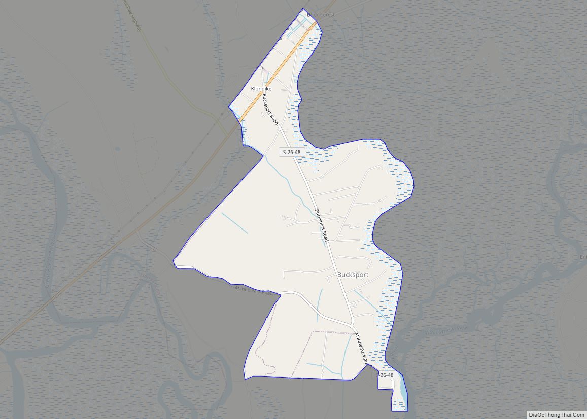
Bucksport is an unincorporated community and census-designated place (CDP) in Horry County, South Carolina, United States. The population was 876 at the 2010 census. It is a rural port on the Atlantic Intracoastal Waterway at the merger point with the Waccamaw River. The port has some services available for boaters and is also home to … Read more

Map of Brunson town

Map of Brunson town

Brunson is a town in Hampton County, South Carolina, United States. The population was 554 at the 2010 census. Brunson town overview: Name: Brunson town LSAD Code: 43 LSAD Description: town (suffix) State: South Carolina County: Hampton County Elevation: 135 ft (41 m) Total Area: 1.02 sq mi (2.63 km²) Land Area: 1.02 sq mi (2.63 km²) Water Area: 0.00 sq mi (0.00 km²) Total Population: … Read more

Map of Brookdale CDP, South Carolina

Map of Brookdale CDP, South Carolina

Brookdale is a census-designated place (CDP) in Orangeburg County, South Carolina, United States. The population was 4,724 at the 2000 census. Brookdale CDP overview: Name: Brookdale CDP LSAD Code: 57 LSAD Description: CDP (suffix) State: South Carolina County: Orangeburg County Elevation: 213 ft (65 m) Total Area: 3.65 sq mi (9.44 km²) Land Area: 3.64 sq mi (9.43 km²) Water Area: 0.00 sq mi (0.01 km²) … Read more

Map of Briarcliffe Acres town

Map of Briarcliffe Acres town

Briarcliffe Acres is a town in Horry County, South Carolina, United States, located between Myrtle Beach and North Myrtle Beach. The population was 457 at the 2010 census. Briarcliffe Acres town overview: Name: Briarcliffe Acres town LSAD Code: 43 LSAD Description: town (suffix) State: South Carolina County: Horry County Elevation: 30 ft (9 m) Total Area: 0.64 sq mi … Read more

Map of Cayce city, South Carolina

Map of Cayce city, South Carolina

Cayce (/ˈkeɪsi/ KAY-see) is a city in the U.S. state of South Carolina, along the Congaree River. The population was 12,528 at the 2010 census and rose to 13,789 in the 2020 United States Census, and it is the third-most populated municipality in Lexington County. The city is primarily in Lexington County, with additional, predominantly … Read more

Map of Catawba CDP, South Carolina

Map of Catawba CDP, South Carolina

Catawba (cuh-TAW-buh) is an unincorporated community in York County, South Carolina, United States, southeast of the city of Rock Hill. The community, Catawba, was once referred to as Catawba Ridge, but this name recently became unpopular. Only tribal elders from the Catawba Indian Reservation now refer to the community as Catawba Ridge. Catawba CDP overview: … Read more

Map of Carlisle town, South Carolina

Map of Carlisle town, South Carolina

Carlisle is a town in Union County, South Carolina, United States. The population was 436 according to the 2010 United States Census. Carlisle town overview: Name: Carlisle town LSAD Code: 43 LSAD Description: town (suffix) State: South Carolina County: Union County Elevation: 456 ft (139 m) Total Area: 1.42 sq mi (3.67 km²) Land Area: 1.42 sq mi (3.67 km²) Water Area: 0.00 sq mi … Read more