Map of Eastover town, South Carolina

Map of Eastover town, South Carolina

Eastover is a town in Richland County, South Carolina, United States. The population was 813 at the 2010 census, down from 830 in 2000. It is part of the Columbia, South Carolina, Metropolitan Statistical Area. Eastover town overview: Name: Eastover town LSAD Code: 43 LSAD Description: town (suffix) State: South Carolina County: Richland County Elevation: … Read more

Map of Estill town

Map of Estill town

Estill is a town in Hampton County, South Carolina, United States. The population was 2,040 at the 2010 census. Estill town overview: Name: Estill town LSAD Code: 43 LSAD Description: town (suffix) State: South Carolina County: Hampton County Elevation: 112 ft (34 m) Total Area: 3.23 sq mi (8.37 km²) Land Area: 3.23 sq mi (8.37 km²) Water Area: 0.00 sq mi (0.00 km²) Total Population: … Read more

Map of Enoree CDP

Map of Enoree CDP

Enoree is a Census-designated place located in Spartanburg County in the U.S. state of South Carolina. According to the 2010 United States Census, the population was 665. Enoree CDP overview: Name: Enoree CDP LSAD Code: 57 LSAD Description: CDP (suffix) State: South Carolina County: Spartanburg County Elevation: 538 ft (164 m) Total Area: 1.59 sq mi (4.11 km²) Land Area: … Read more

Map of Elloree town

Map of Elloree town

Elloree is a town in Orangeburg County, South Carolina, United States. The population was 692 at the 2010 census. Elloree town overview: Name: Elloree town LSAD Code: 43 LSAD Description: town (suffix) State: South Carolina County: Orangeburg County Incorporated: 1886 Elevation: 164 ft (50 m) Total Area: 1.01 sq mi (2.63 km²) Land Area: 1.01 sq mi (2.63 km²) Water Area: 0.00 sq mi (0.00 km²) … Read more

Map of Elko town, South Carolina

Map of Elko town, South Carolina

Elko is a town in Barnwell County, South Carolina, United States. According to the 2010 census the population was 193. Elko town overview: Name: Elko town LSAD Code: 43 LSAD Description: town (suffix) State: South Carolina County: Barnwell County Elevation: 335 ft (102 m) Total Area: 1.05 sq mi (2.72 km²) Land Area: 1.05 sq mi (2.72 km²) Water Area: 0.00 sq mi (0.00 km²) Total … Read more

Map of Elgin CDP, South Carolina

Map of Elgin CDP, South Carolina

Elgin is an unincorporated community and census-designated place (CDP) in Lancaster County, South Carolina, United States. The population was 2,607 at the 2010 census. Elgin CDP overview: Name: Elgin CDP LSAD Code: 57 LSAD Description: CDP (suffix) State: South Carolina County: Lancaster County Elevation: 600 ft (200 m) Total Area: 4.88 sq mi (12.63 km²) Land Area: 4.86 sq mi (12.58 km²) Water … Read more

Map of Ehrhardt town

Map of Ehrhardt town

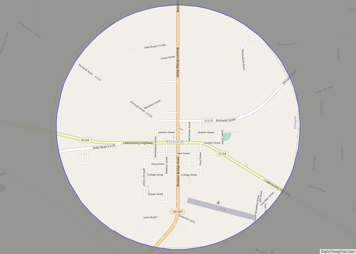
Ehrhardt is a town in Bamberg County, South Carolina, United States. As of the 2010 census, the town population was 545. Ehrhardt town overview: Name: Ehrhardt town LSAD Code: 43 LSAD Description: town (suffix) State: South Carolina County: Bamberg County Elevation: 141 ft (43 m) Total Area: 3.11 sq mi (8.06 km²) Land Area: 3.11 sq mi (8.06 km²) Water Area: 0.00 sq mi (0.00 km²) … Read more

Map of Edisto CDP

Map of Edisto CDP

Edisto Island is one of South Carolina’s Sea Islands, the larger part of which lies in Charleston County, with its southern tip in Colleton County. The town of Edisto Beach is in Colleton County, while the Charleston County part of the island is unincorporated. The island, the town, and the Edisto River are named after … Read more

Map of Edisto Beach town

Map of Edisto Beach town

Edisto Beach is a town in Colleton County, South Carolina, United States. Edisto Beach’s population was 414 as of the 2010 census, down from 641 in 2000. The town limits include only the developed coastal area of Edisto Island within Colleton County, while the majority of the island consists of unincorporated land in Charleston County. … Read more

Map of Florence city, South Carolina

Map of Florence city, South Carolina

Florence /ˈflɒrəns/ is a city in and the county seat of Florence County, South Carolina, United States. It lies at the intersection of Interstates 20 and 95 and is the eastern terminus of the former. It is the primary city within the Florence metropolitan area. The area forms the core of the historical Pee Dee … Read more

Map of Five Forks CDP

Map of Five Forks CDP

Five Forks is a census-designated place (CDP) in Greenville County, South Carolina, United States. The population was 17,737 at the 2020 census, up from 14,140 in 2010, and 8,064 in 2000. It is a growing, affluent suburb of Greenville and is part of the Greenville–Mauldin–Easley Metropolitan Statistical Area. Five Forks CDP overview: Name: Five Forks … Read more

Map of Fingerville CDP

Map of Fingerville CDP

Fingerville is a Census-designated place located in Spartanburg County in the U.S. State of South Carolina. According to the 2010 United States Census, the population was 134. Fingerville CDP overview: Name: Fingerville CDP LSAD Code: 57 LSAD Description: CDP (suffix) State: South Carolina County: Spartanburg County Elevation: 791 ft (241 m) Total Area: 0.24 sq mi (0.63 km²) Land Area: … Read more