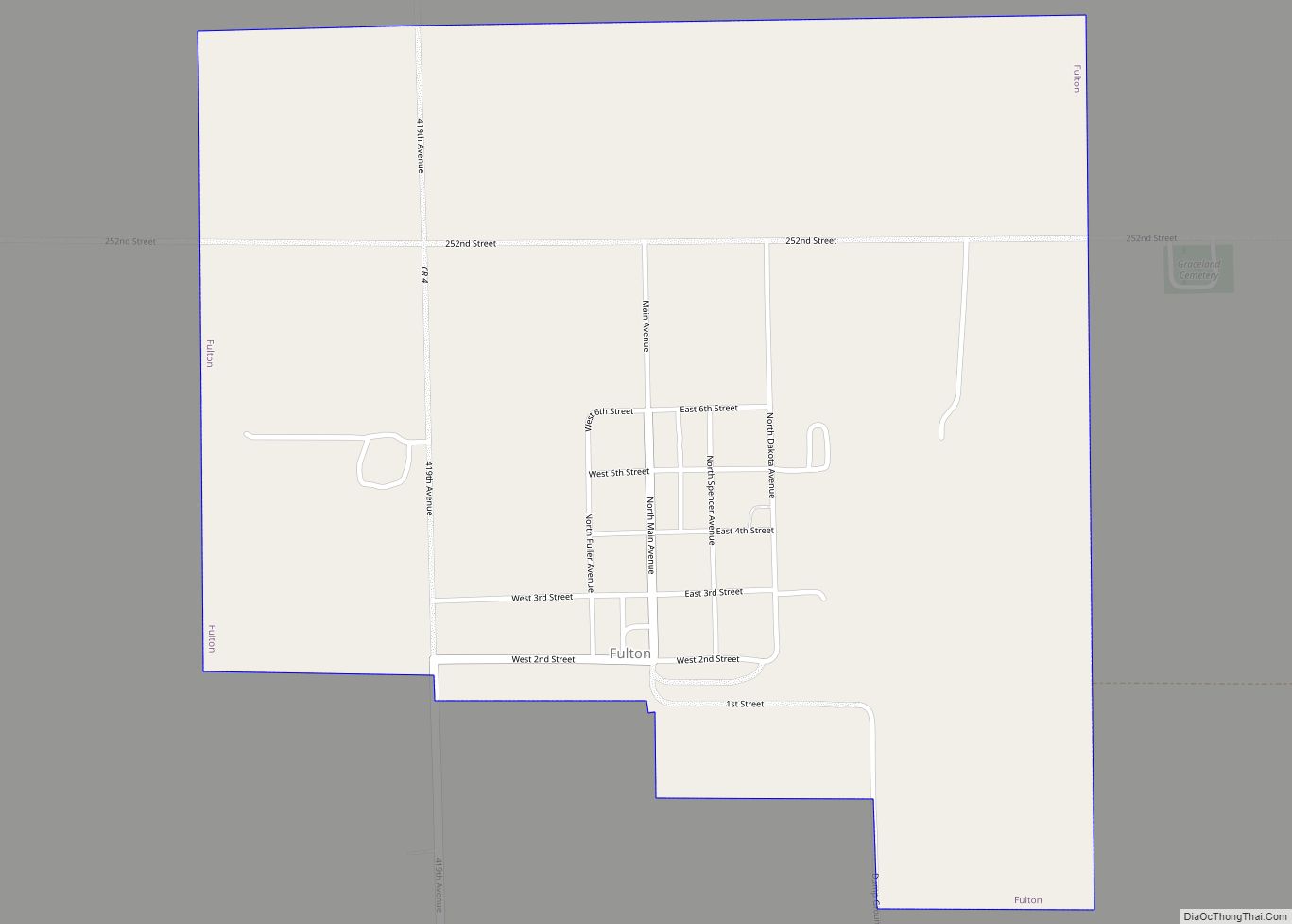
Map of Frederick town, South Dakota

Map of Frederick town, South Dakota

Frederick is a town in northwestern Brown County, South Dakota, United States. The population was 215 at the 2020 census. Home to the annual Frederick Finn Fest, the town is part of the Aberdeen Micropolitan Statistical Area. Frederick town overview: Name: Frederick town LSAD Code: 43 LSAD Description: town (suffix) State: South Dakota County: Brown … Read more

Map of Green Grass CDP

Map of Green Grass CDP

Green Grass (Lakota: wakpála phežŋ; “creek [of the] grass”) is a census-designated place (CDP) in Dewey County, South Dakota, United States. The population was 21 at the 2020 census. The community takes its name from nearby Green Grass Creek. Green Grass CDP overview: Name: Green Grass CDP LSAD Code: 57 LSAD Description: CDP (suffix) State: … Read more

Map of Goodwin town

Map of Goodwin town

Goodwin is a town in Deuel County, South Dakota, United States, where the population was 147 at the 2020 census. Goodwin town overview: Name: Goodwin town LSAD Code: 43 LSAD Description: town (suffix) State: South Dakota County: Deuel County Elevation: 1,998 ft (609 m) Total Area: 0.47 sq mi (1.23 km²) Land Area: 0.47 sq mi (1.23 km²) Water Area: 0.00 sq mi (0.00 km²) Total … Read more

Map of Goodwill CDP

Map of Goodwill CDP

Goodwill is an unincorporated community and former census-designated place (CDP) in Roberts County, South Dakota, United States. Prior to the 2020 Census, the CDP was merged into the Agency Village census-designated place. Over 90% of the population is Native American. Goodwill CDP overview: Name: Goodwill CDP LSAD Code: 57 LSAD Description: CDP (suffix) State: South … Read more

Map of Glenham town

Map of Glenham town

Glenham is a town in Walworth County, South Dakota, United States. The population was 112 at the 2020 census. Glenham was laid out in 1900, and named for a glen near the town site. Glenham town overview: Name: Glenham town LSAD Code: 43 LSAD Description: town (suffix) State: South Dakota County: Walworth County Incorporated: 1907 … Read more

Map of Gettysburg city, South Dakota

Map of Gettysburg city, South Dakota

Gettysburg is a city and county seat of Potter County, South Dakota, United States, along the 45th parallel. The population was 1,104 at the 2020 census. Gettysburg city overview: Name: Gettysburg city LSAD Code: 25 LSAD Description: city (suffix) State: South Dakota County: Potter County Incorporated: 1907 Elevation: 2,064 ft (629 m) Total Area: 1.92 sq mi (4.97 km²) Land … Read more

Map of Hamill CDP

Map of Hamill CDP

Hamill is a rural hamlet in Tripp County, South Dakota, United States. The population was 14 at the 2020 census. There is a post office at Hamill, also two churches and a community hall; otherwise, no businesses or services. Hamill CDP overview: Name: Hamill CDP LSAD Code: 57 LSAD Description: CDP (suffix) State: South Dakota … Read more

Map of Groton city, South Dakota

Map of Groton city, South Dakota

Groton is a city in southeastern Brown County, South Dakota, United States. The population was 1,380 at the 2020 census. Groton city overview: Name: Groton city LSAD Code: 25 LSAD Description: city (suffix) State: South Dakota County: Brown County Incorporated: 1888 Elevation: 1,302 ft (397 m) Total Area: 1.75 sq mi (4.54 km²) Land Area: 1.75 sq mi (4.54 km²) Water Area: 0.00 sq mi … Read more

Map of Grenville town, South Dakota

Map of Grenville town, South Dakota

Grenville is a town in Day County, South Dakota, United States. The population was 48 at the 2020 census. Grenville was laid out in 1914, and named for the greenery of the original town site. Grenville town overview: Name: Grenville town LSAD Code: 43 LSAD Description: town (suffix) State: South Dakota County: Day County Incorporated: … Read more

Map of Gregory city, South Dakota

Map of Gregory city, South Dakota

Gregory is a city in western Gregory County, South Dakota, United States. The population was 1,221 at the 2020 census. Gregory city overview: Name: Gregory city LSAD Code: 25 LSAD Description: city (suffix) State: South Dakota County: Gregory County Incorporated: December 7, 1908 Elevation: 2,169 ft (661 m) Total Area: 1.72 sq mi (4.46 km²) Land Area: 1.72 sq mi (4.46 km²) Water … Read more

Map of Green Valley CDP, South Dakota

Map of Green Valley CDP, South Dakota

Green Valley is a census-designated place (CDP) and unincorporated community in Pennington County, South Dakota, United States. The population was 1,051 at the 2020 census. Green Valley CDP overview: Name: Green Valley CDP LSAD Code: 57 LSAD Description: CDP (suffix) State: South Dakota County: Pennington County Total Area: 3.7 sq mi (9.6 km²) Land Area: 3.7 sq mi (9.6 km²) Water … Read more

Map of Herreid city

Map of Herreid city

Herreid is a city in Campbell County, South Dakota, United States. The population was 416 at the 2020 census. Herreid was laid out in 1901 when a branch of the Soo Line reached the city, and named after Charles N. Herreid, fourth Governor of South Dakota. Herreid city overview: Name: Herreid city LSAD Code: 25 … Read more