Map of Tyndall city

Map of Tyndall city

Tyndall (pronounced TIN’-duhl) is a city in and the county seat of Bon Homme County, South Dakota, United States. The population was 1,057 at the 2020 census. Tyndall city overview: Name: Tyndall city LSAD Code: 25 LSAD Description: city (suffix) State: South Dakota County: Bon Homme County Incorporated: 1887 Elevation: 1,421 ft (433 m) Total Area: 1.58 sq mi … Read more

Map of Vilas town, South Dakota

Map of Vilas town, South Dakota

Vilas is a town in Miner County, South Dakota, United States. The population was 29 at the 2020 census. Vilas town overview: Name: Vilas town LSAD Code: 43 LSAD Description: town (suffix) State: South Dakota County: Miner County Incorporated: 1910 Elevation: 1,480 ft (451 m) Total Area: 2.98 sq mi (7.71 km²) Land Area: 2.98 sq mi (7.71 km²) Water Area: 0.00 sq mi (0.00 km²) … Read more

Map of Vienna town, South Dakota

Map of Vienna town, South Dakota

Vienna (/vaɪˈɛnə/) is a town in Clark County, South Dakota, United States. The population was 49 at the 2020 census. A large share of the early settlers were natives of Austria who named the village after the Austrian capital. Vienna town overview: Name: Vienna town LSAD Code: 43 LSAD Description: town (suffix) State: South Dakota … Read more

Map of Viborg city

Map of Viborg city

Viborg (/vaɪˈbɜːrɡ/; VY-burg) is a city in Turner County, South Dakota, United States. The population was 814 at the 2020 census. Viborg city overview: Name: Viborg city LSAD Code: 25 LSAD Description: city (suffix) State: South Dakota County: Turner County Incorporated: 1903 Elevation: 1,306 ft (398 m) Total Area: 0.52 sq mi (1.34 km²) Land Area: 0.52 sq mi (1.34 km²) Water Area: … Read more

Map of Vermillion city, South Dakota

Map of Vermillion city, South Dakota

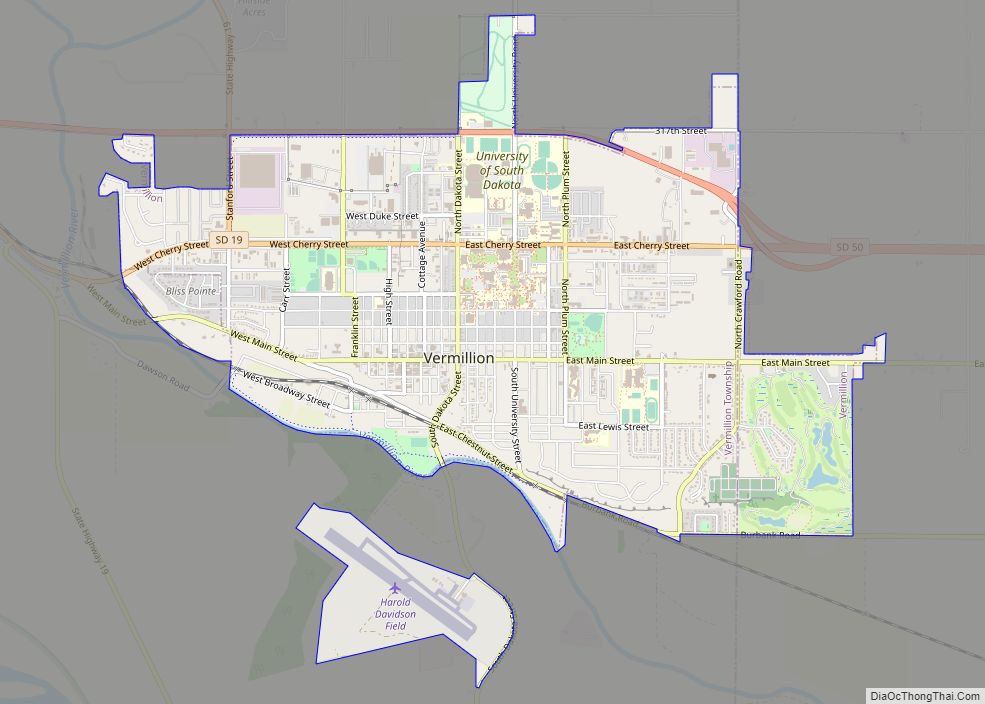
Vermillion (Lakota: Waséoyuze; “The Place Where Vermilion is Obtained”) is a city in the county seat of Clay County. It is in the southeastern corner of South Dakota, United States, and is the state’s 12th-largest city. According to the 2020 Census, the population was 11,695. The city lies atop a bluff near the Missouri River. … Read more

Map of Verdon town, South Dakota

Map of Verdon town, South Dakota

Verdon is a town in southeastern Brown County, South Dakota, United States. The population was 3 at the 2020 census. Verdon town overview: Name: Verdon town LSAD Code: 43 LSAD Description: town (suffix) State: South Dakota County: Brown County Incorporated: 1884 Elevation: 1,306 ft (398 m) Total Area: 0.25 sq mi (0.65 km²) Land Area: 0.25 sq mi (0.65 km²) Water Area: 0.00 sq mi … Read more

Map of Veblen city

Map of Veblen city

Veblen is a city in Marshall County, South Dakota, United States. The population was 317 at the 2020 census. Sioux country singer and actor Floyd Red Crow Westerman is buried here at Saint Matthew’s Catholic Cemetery. Veblen city overview: Name: Veblen city LSAD Code: 25 LSAD Description: city (suffix) State: South Dakota County: Marshall County … Read more

Map of Ward town, South Dakota

Map of Ward town, South Dakota

Ward is a town in Moody County, South Dakota, United States. The population was 34 at the 2020 census. Ward town overview: Name: Ward town LSAD Code: 43 LSAD Description: town (suffix) State: South Dakota County: Moody County Elevation: 1,755 ft (535 m) Total Area: 0.29 sq mi (0.75 km²) Land Area: 0.29 sq mi (0.75 km²) Water Area: 0.00 sq mi (0.00 km²) Total Population: … Read more

Map of Wanblee CDP

Map of Wanblee CDP

Wanblee (Lakota: Waŋblí Hoȟpi; “Golden Eagle Nest”) is a census-designated place on the Pine Ridge Indian Reservation, located in Jackson County, South Dakota, United States. The population was 674 at the 2020 census, virtually all of whom are members of the Oglala band of Lakota Sioux. Wanbli is the Lakota word for eagle, and the … Read more

Map of Wallace town, South Dakota

Map of Wallace town, South Dakota

Wallace is a town in Codington County, South Dakota, United States. The population was 91 at the 2020 census. It is part of the Watertown, South Dakota Micropolitan Statistical Area. Wallace town overview: Name: Wallace town LSAD Code: 43 LSAD Description: town (suffix) State: South Dakota County: Codington County Incorporated: 1908 Elevation: 1,778 ft (542 m) Total … Read more

Map of Wall town, South Dakota

Map of Wall town, South Dakota

Wall (Lakota: Makȟóšiča Aglágla Otȟuŋwahe, “Town alongside the Badlands”) is a town in Pennington County, South Dakota, United States. The population was 699 at the 2020 census. Wall town overview: Name: Wall town LSAD Code: 43 LSAD Description: town (suffix) State: South Dakota County: Pennington County Incorporated: 1908 Elevation: 2,825 ft (861 m) Total Area: 2.71 sq mi (7.02 km²) … Read more

Map of Wakonda town

Map of Wakonda town

Wakonda is a town in Clay County, South Dakota, United States. The population was 347 at the 2020 census. Wakonda town overview: Name: Wakonda town LSAD Code: 43 LSAD Description: town (suffix) State: South Dakota County: Clay County Elevation: 1,391 ft (424 m) Total Area: 0.39 sq mi (1.00 km²) Land Area: 0.39 sq mi (1.00 km²) Water Area: 0.00 sq mi (0.00 km²) Total Population: … Read more