Map of Jefferson City, Tennessee

Map of Jefferson City, Tennessee

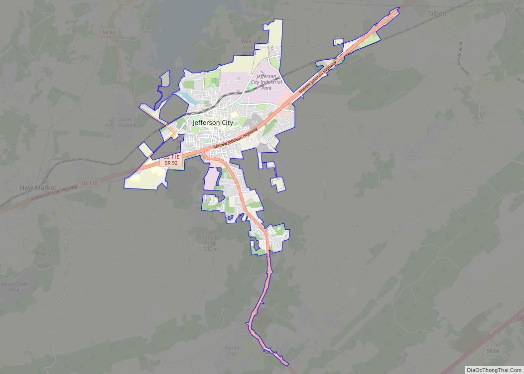
Jefferson City (originally named Mossy Creek) is a city in Jefferson County, Tennessee, United States. It is part of the Morristown Metropolitan Statistical Area. As of the 2020 census the population was 8,419. Jefferson City overview: Name: Jefferson City LSAD Code: 25 LSAD Description: city (suffix) State: Tennessee County: Jefferson County Incorporated: 1901 Elevation: 1,161 ft … Read more

Map of Jasper town, Tennessee

Map of Jasper town, Tennessee

Jasper is a town in and the county seat of Marion County, Tennessee, United States. The population was 3,612 at the 2020 census. The town was formed in 1820 from lands acquired from Betsy Pack (1770–1851), daughter of Cherokee Chief John Lowery. Jasper is part of the Chattanooga, TN–GA Metropolitan Statistical Area. Jasper town overview: … Read more

Map of Jamestown city, Tennessee

Map of Jamestown city, Tennessee

Jamestown is a city in and the county seat of Fentress County, Tennessee, United States. The population of the city was 1,959 at the 2010 census. Jamestown city overview: Name: Jamestown city LSAD Code: 25 LSAD Description: city (suffix) State: Tennessee County: Fentress County Founded: 1823 Incorporated: 1837 Elevation: 1,716 ft (523 m) Total Area: 3.11 sq mi (8.07 km²) … Read more

Map of Lafayette city, Tennessee

Map of Lafayette city, Tennessee

Lafayette /ləˈfeɪɪt/ is a city in Macon County, Tennessee, United States. The population was 4,474 at the 2010 census, and had 5,584 in 2020. It is the county seat of Macon County. Lafayette city overview: Name: Lafayette city LSAD Code: 25 LSAD Description: city (suffix) State: Tennessee County: Macon County Elevation: 958 ft (292 m) Total Area: … Read more

Map of La Vergne city

Map of La Vergne city

La Vergne (/ləˈvɜːrn/ lə-VURN) is a city in Rutherford County, Tennessee, United States. The population was 38,719 at the 2020 census. La Vergne lies within the Nashville Metropolitan Statistical Area. La Vergne city overview: Name: La Vergne city LSAD Code: 25 LSAD Description: city (suffix) State: Tennessee County: Rutherford County Elevation: 584 ft (178 m) Total Area: … Read more

Map of La Grange town, Tennessee

Map of La Grange town, Tennessee

La Grange town overview: Name: La Grange town LSAD Code: 43 LSAD Description: town (suffix) State: Tennessee County: Fayette County FIPS code: 4740200 Online Interactive Map La Grange online map. Source: Basemap layers from Google Map, Open Street Map (OSM), Arcgisonline, Wmflabs. Boundary Data from Database of Global Administrative Areas. La Grange location map. Where … Read more

Map of La Follette city

Map of La Follette city

La Follette city overview: Name: La Follette city LSAD Code: 25 LSAD Description: city (suffix) State: Tennessee County: Campbell County FIPS code: 4740180 Online Interactive Map La Follette online map. Source: Basemap layers from Google Map, Open Street Map (OSM), Arcgisonline, Wmflabs. Boundary Data from Database of Global Administrative Areas. La Follette location map. Where … Read more

Map of Kingston city, Tennessee

Map of Kingston city, Tennessee

Kingston is a city in and the county seat of Roane County, Tennessee, United States. This city is thirty-six miles southwest of Knoxville. It had a population of 5,934 at the 2010 United States census, and is included in the Harriman Micropolitan Statistical Area. Kingston is adjacent to Watts Bar Lake. Kingston city overview: Name: … Read more

Map of Lakewood Park CDP, Tennessee

Map of Lakewood Park CDP, Tennessee

Lakewood Park is a census-designated place in Coffee County, Tennessee, United States. The population was 1,161 at the 2020 census, up from 990 at the 2010 census. It is located near Tennessee State Route 280, north of Manchester. Lakewood Park CDP overview: Name: Lakewood Park CDP LSAD Code: 57 LSAD Description: CDP (suffix) State: Tennessee … Read more

Map of Lakesite city

Map of Lakesite city

Lakesite is a city in Hamilton County, Tennessee, United States. The population was 1,856 at the 2020 census. It is a northern suburb of the Chattanooga, TN–GA Metropolitan Statistical Area, located 15 miles north of the city. Lakesite city overview: Name: Lakesite city LSAD Code: 25 LSAD Description: city (suffix) State: Tennessee County: Hamilton County … Read more

Map of Lakeland city, Tennessee

Map of Lakeland city, Tennessee

Lakeland is a city in Shelby County, Tennessee, United States, and a part of the Memphis metropolitan area. The population was 12,430 at the 2010 census. Lakeland city overview: Name: Lakeland city LSAD Code: 25 LSAD Description: city (suffix) State: Tennessee County: Shelby County Elevation: 397 ft (121 m) Total Area: 23.87 sq mi (61.83 km²) Land Area: 23.46 sq mi (60.75 km²) … Read more

Map of Lake Tansi CDP

Map of Lake Tansi CDP

Lake Tansi Village (also known as Lake Tansi) is a resort community in Cumberland County, Tennessee, United States, recognized by the U.S. Census as a census-designated place (CDP). The population was 5,629 at the 2020 census. Lake Tansi CDP overview: Name: Lake Tansi CDP LSAD Code: 57 LSAD Description: CDP (suffix) State: Tennessee County: Cumberland … Read more