Map of Nashville-Davidson metropolitan government (balance)

Map of Nashville-Davidson metropolitan government (balance)

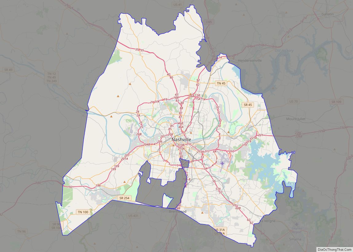
Nashville-Davidson metropolitan government (balance) overview: Name: Nashville-Davidson metropolitan government (balance) LSAD Code: 00 LSAD Description: 0 State: Tennessee County: Davidson County FIPS code: 4752006 Discover the vibrant city of Nashville with our interactive Nashville map. Featuring highways, roads, places, and major landmarks, this map will help you explore the city with ease. Nashville is located … Read more

Map of Knoxville city, Tennessee

Map of Knoxville city, Tennessee

Knoxville is a city in and the county seat of Knox County, Tennessee, United States. As of the 2020 United States census, Knoxville’s population was 190,740, making it the largest city in the East Tennessee Grand Division and the state’s third largest city after Nashville and Memphis. It is the principal city of the Knoxville … Read more

Map of Chattanooga city, Tennessee

Map of Chattanooga city, Tennessee

Chattanooga (/ˌtʃætəˈnuːɡə/ CHAT-ə-NOO-gə) is a city in and the county seat of Hamilton County, Tennessee, United States. Located along the Tennessee River bordering Georgia, it also extends into Marion County on its western end. With a population of 181,099 in 2020, it is Tennessee’s fourth-largest city and one of the two principal cities of East … Read more

Map of Clarksville city, Tennessee

Map of Clarksville city, Tennessee

Clarksville is the county seat of Montgomery County, Tennessee, United States. It is the fifth-largest city in the state behind Nashville, Memphis, Knoxville, and Chattanooga. The city had a population of 166,722 as of the 2020 United States census. It is the principal central city of the Clarksville metropolitan area, which consists of Montgomery and … Read more

Map of Murfreesboro city, Tennessee

Map of Murfreesboro city, Tennessee

Murfreesboro is a city in, and county seat of, Rutherford County, Tennessee, United States. The population was 152,769 according to the 2020 census, up from 108,755 residents certified in 2010. Murfreesboro is located in the Nashville metropolitan area of Middle Tennessee, 34 miles (55 km) southeast of downtown Nashville. Serving as the state capital from 1818 … Read more

Map of Adamsville town, Tennessee

Map of Adamsville town, Tennessee

Adamsville is a town in Hardin and McNairy counties, Tennessee, United States. The population was 2,207 at the 2010 census. Adamsville is named after George D. Adams, who operated an inn and stagecoach stop in the 1840s. Adamsville’s nickname is the “Biggest Little Town in Tennessee” and was the home of Sheriff Buford Pusser. Adamsville … Read more

Map of Adams city, Tennessee

Map of Adams city, Tennessee

Adams is a city in Robertson County, Tennessee, United States. It is near the Kentucky state line. The population was 624 at the 2020 census. Adams city overview: Name: Adams city LSAD Code: 25 LSAD Description: city (suffix) State: Tennessee County: Robertson County Incorporated: 1963 Elevation: 548 ft (167 m) Total Area: 2.39 sq mi (6.19 km²) Land Area: 2.39 sq mi … Read more

Map of Allardt city

Map of Allardt city

Allardt is a city in Fentress County, Tennessee, United States. The population was 555 at the 2020 census. The current mayor Ms. Patricia (Pat) Brown Clark was elected in 2018. According to the city charter, there are three city council board members, currently (as of 2018) Chris Crabtree, Thomas Potter, and Michael Wiley. Allardt city … Read more

Map of Algood city

Map of Algood city

Algood is a city in Putnam County, Tennessee, United States. The population was 3,963 at the 2020 census. It is part of the Cookeville Micropolitan Statistical Area. Algood city overview: Name: Algood city LSAD Code: 25 LSAD Description: city (suffix) State: Tennessee County: Putnam County Incorporated: 1911 Elevation: 1,112 ft (339 m) Total Area: 4.09 sq mi (10.59 km²) Land … Read more

Map of Alexandria town, Tennessee

Map of Alexandria town, Tennessee

Alexandria is a town in DeKalb County, Tennessee, United States. The population was 966 at the 2010 census. Alexandria town overview: Name: Alexandria town LSAD Code: 43 LSAD Description: town (suffix) State: Tennessee County: DeKalb County Elevation: 653 ft (199 m) Total Area: 2.02 sq mi (5.25 km²) Land Area: 2.02 sq mi (5.25 km²) Water Area: 0.00 sq mi (0.00 km²) Total Population: 981 Population … Read more

Map of Alcoa city

Map of Alcoa city

Alcoa is a city in Blount County, Tennessee, United States, south of Knoxville. Its population was 10,978 at the 2020 census. It is part of the Knoxville, Tennessee Metropolitan Statistical Area. As its name suggests, Alcoa was the site of a large aluminum smelting plant owned and operated by the Alcoa corporation (Aluminum Company of … Read more